Multi-unmanned aerial vehicle path determining method and device for three-dimensional model reestablishment

A 3D model and path determination technology, applied in 3D modeling, special data processing applications, image data processing, etc., can solve the problems of reducing the efficiency and cost of 3D reconstruction

Active Publication Date: 2017-01-04
SHENZHEN GRADUATE SCHOOL TSINGHUA UNIV
View PDF3 Cites 22 Cited by
  • Summary
  • Abstract
  • Description
  • Claims
  • Application Information

AI Technical Summary

Problems solved by technology

The existing texture image acquisition process relies on manual control, and the UAV flight trajectory and camera shooting interval are determined empirically
In order to ensure that the overlap rate of photos meets the requirements of 3D reconstruction, a large number of redundant images and photos are often taken by setting dense flight trajectories and small shooting intervals, causing 3D reconstruction software to spend a lot of time matching and processing redundant information , reducing the efficiency of 3D reconstruction

Method used


Image

  • Multi-unmanned aerial vehicle path determining method and device for three-dimensional model reestablishment
  • Multi-unmanned aerial vehicle path determining method and device for three-dimensional model reestablishment
  • Multi-unmanned aerial vehicle path determining method and device for three-dimensional model reestablishment

Examples


Embodiment Construction

[0032] The preferred embodiments of the invention will be further described in detail below.

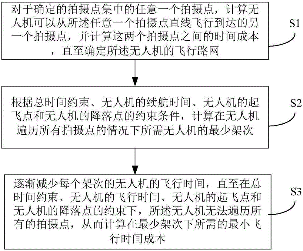
[0033] Such as figure 1 As shown in the process, a method for determining the paths of multiple UAVs reconstructed from a three-dimensional model of an embodiment includes the following steps:

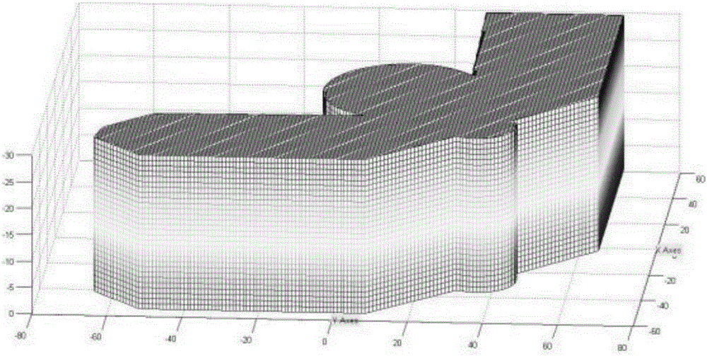
[0034] S1. Construct a three-dimensional point model that constitutes the outline of the building to be photographed

[0035] The facades of most buildings are vertical or nearly vertical to the ground, so the cross-sectional outline of the building can be accurately outlined according to the orthophoto image of the building. Users can easily obtain orthophoto images of buildings from Internet maps (such as Baidu satellite maps and Google satellite maps). Set the local NED coordinate system so that the X-axis faces north, the Y-axis faces east, the Z-axis faces down perpendicular to the ground plane, and the origin is on the ground plane. The length of the building on the Y axis, the width...


PUM


Abstract

The invention discloses a multi-unmanned aerial vehicle path determining method and device for three-dimensional model reestablishment. The method comprises the steps of calculating that an unmanned aerial vehicle can fly from any photographing point to another photographing point along a straight line, calculating the time cost between the two photographing points until a flight road network of the unmanned aerial vehicle is determined; calculating required least sorties of the unmanned aerial vehicle under the condition that the unmanned aerial vehicle traverses all the photographing points according to total time constraint, the cruising duration of the unmanned aerial vehicle, a takeoff point of the unmanned aerial vehicle and a constraint condition of a landing point of the unmanned aerial vehicle; and gradually reducing the flight time of the unmanned aerial vehicle in each sortie until the unmanned aerial vehicle cannot traverse all the photographing points, and calculating the required least flight time cost in the least sorties. In an emergency management process, when a three-dimensional reestablishment data collection task has clear time constraint, according to the method and the device, the required fly sorties and the flight paths and photographing task points of each sortie can be accurately calculated.

Description

【Technical field】 [0001] The invention relates to a method and a device for determining paths of multiple unmanned aerial vehicles for three-dimensional model reconstruction. 【Background technique】 [0002] Spatial information is an important basic data, and its collection and application run through the entire process of emergency management. Existing spatial information is mostly expressed in the form of two-dimensional maps, and many valuable terrain and feature details such as texture, height, and shape information are difficult to present. In the process of emergency management, the 3D real scene map can provide more intuitive and detailed spatial information, and provide better support for emergency decision-making. [0003] In order to obtain a high-precision 3D model of the building, it is necessary to fly around the building layer by layer to completely obtain the surface texture information of the building. The existing texture image acquisition process relies on...

Claims


Application Information

Patent Timeline
Patent Type & Authority Applications(China)
IPC IPC(8): G06F19/00G06T17/00
CPCG06T17/00G16Z99/00
Inventor 王飞郑晓翠
Owner SHENZHEN GRADUATE SCHOOL TSINGHUA UNIV
Why Eureka
Try Eureka