The drawing method of the site to be drawn

A drawing method and site technology, applied in the field of surveying and mapping, can solve the problems of incorrect graphic proportions, complex measuring methods, large drawing errors, etc., and achieve the effects of reducing labor costs, improving work efficiency, and simplifying the process of data collection.

Active Publication Date: 2021-07-23
QIANXUN SPATIAL INTELLIGENCE INC
View PDF4 Cites 0 Cited by
  • Summary
  • Abstract
  • Description
  • Claims
  • Application Information

AI Technical Summary

Problems solved by technology

[0010] In the measurement process of the above-mentioned drawing method, there are relatively human factors in the measurement by traditional tools such as a tape measure, which requires a lot of specialization, because accurate mapping of the drawing to the actual ground requires professional knowledge, and for the measurement of complex scenes The method is relatively complicated, and it is prone to problems such as incorrect proportions of the drawn graphics and large errors such as deformation during the drawing process
To be able to effectively improve driving training skills requires standard and accurate driving practice site graphics. If the drawing error is found to be large, it may need to be reworked and redrawn, which will take a long time

Method used


Image

  • The drawing method of the site to be drawn
  • The drawing method of the site to be drawn
  • The drawing method of the site to be drawn

Examples


Embodiment 1

[0065] Embodiment 1: Drawing method of driving training site

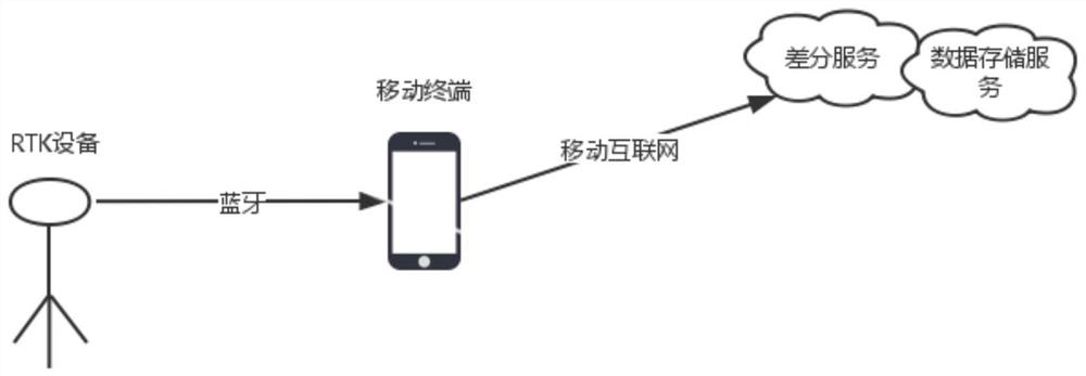
[0066] In the drawing method of the driving training site in one embodiment of the present invention, the device connection can refer to figure 1 . figure 1 Among them, differential service refers to providing GNSS carrier phase differential service to RTK equipment. The data storage service refers to the standard electronic drawing service for the driver training program provided to the software of the mobile terminal. In addition, the actual electronic map of the driving training site with real coordinates drawn and collected by the mobile terminal can be stored, which is convenient for use in the driving training system. and, figure 1 In RTK, the RTK device receives the differential service received by the mobile terminal through wireless means such as Bluetooth to perform RTK calculation, and at the same time sends the high-precision positioning coordinate information after calculation to the mobile terminal...

Embodiment 2

[0088] Embodiment 2: Drawing method of driving training site

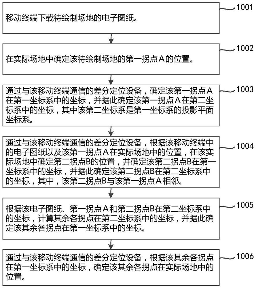
[0089] Such as Figure 6 As shown, the drawing method of the site to be drawn in this embodiment includes the following steps:

[0090] In step 101: the mobile terminal downloads the site information of the driving training site to be drawn, and the site information includes electronic drawings and data of the driving training site.

[0091] Specifically, in this step, the mobile terminal downloads the electronic drawing data of the driving training project to be drawn from the data storage server. The electronic drawing contains the coordinates of each inflection point of the graphic, and these coordinates are local plane coordinates based on the origin A point.

[0092] Thereafter, in step 102: the first inflection point A is determined in the actual site.

[0093] Thereafter, in step 103: the coordinates of the first inflection point A in the WGS84 coordinate system are determined by the RTK device.

[0094] ...


PUM


Abstract

The invention discloses a drawing method for a site to be drawn, comprising: downloading electronic drawings by a mobile terminal; determining the position of a first inflection point A of the site in an actual site; determining the coordinates of the first inflection point A in a first coordinate system, and Based on this, determine the coordinates of the first inflection point A in the second coordinate system; determine the position of the second inflection point B in the actual site, and determine the coordinates of the second inflection point B in the first coordinate system, and determine the first inflection point B accordingly. The coordinates of the second inflection point B in the second coordinate system, the second inflection point B is adjacent to the first inflection point A; calculate the coordinates of the remaining inflection points in the second coordinate system, and accordingly determine the remaining inflection points in the first coordinate system coordinates; determine the positions of the remaining inflection points in the actual field. The invention can simplify the process of field surveying and mapping and the information collection of inflection point position, and improve the accuracy.

Description

technical field [0001] The invention relates to the field of surveying and mapping, in particular to the surveying and mapping technology for driving training sites. Background technique [0002] With the popularity of private vehicles, the demand for driving training is growing rapidly. [0003] During driving training, it is necessary to practice in a driving project venue with clear markings. For example, driving training such as reversing into a garage and other driving events requires marking lines on the ground that are suitable for reversing into a garage. [0004] At present, differential positioning based on the global positioning system is widely used in driving training and examinations across the country. Combining vehicle contour coordinate data to judge the relative position of the driving vehicle position and the collected electronic drawings of the driving site to determine the correctness of driving. Sexuality is judged. To complete these judgments, it is ...

Claims


Application Information

Patent Timeline
Patent Type & Authority Patents(China)
IPC IPC(8): G06T11/20G06Q50/20
CPCG06Q50/20G06T11/20
Inventor 李学锋
Owner QIANXUN SPATIAL INTELLIGENCE INC
Why Eureka
Try Eureka