
A Method of Measuring Paleo-flow Direction Using Electrical Imaging Logging

An electrical imaging and well logging technology, which is applied to the electrical/magnetic detection for logging records, etc., can solve the problems of not mentioning the technical scheme of measuring the ancient flow direction, the uncertainty of analysis results, and the enhancement of multi-solution, etc. Achieve scientific and reliable measurement process principle, convenient subsequent statistical analysis, and good measurement accuracy.

Active Publication Date: 2019-08-06
CHINA UNIV OF PETROLEUM (EAST CHINA)
View PDF1 Cites 0 Cited by
  • Summary
  • Abstract
  • Description
  • Claims
  • Application Information

AI Technical Summary

Problems solved by technology

Formation dip logging can obtain continuous formation information with high vertical resolution, but there are only 4 to 8 measurement curves, which can only be processed by correlation comparison method, and the effect is better when the formation distribution is stable and continuous , when the formation is vertically complex and variable or has strong heterogeneity, the reliability becomes worse and multi-solutions increase, and its interpretation and utilization results are often questioned
Chinese patent application number CN201510073967.7 discloses a method for measuring clay content in complex formations based on electrical imaging logging data, which can provide accurate clay content data, thereby laying the foundation for formation evaluation and fluid identification, but does not mention A technical solution for determining paleo-flow direction; therefore, people continue to search for new technical methods, but the technology of using electrical imaging logging data to determine paleo-flow direction has not yet been reported
[0006] With the advancement of logging technology, electrical imaging logging technology developed from formation dip logging has been widely used because it can provide high-resolution borehole wall images. Compared with formation dip data, electrical imaging can not only provide Dip angle and azimuth, common sedimentary structures are also shown in the figure, therefore, by identifying the sedimentary structure, it is possible to determine the paleo-flow direction by using the blue mode, green mode or rose diagram presented in the dip vector result map, but there are problems with this method It is necessary for processing personnel to have certain interpretation experience, clarify the response modes of various paleoflow direction marks in the imaging map, and identify and pick up a large number of sedimentary structures with relevant characteristics in the map through human-computer interaction. The time cost is high and the analysis results with some uncertainty

Method used


Image

  • A Method of Measuring Paleo-flow Direction Using Electrical Imaging Logging
  • A Method of Measuring Paleo-flow Direction Using Electrical Imaging Logging
  • A Method of Measuring Paleo-flow Direction Using Electrical Imaging Logging

Examples


Embodiment 1

[0043] The method for determining the paleo-flow direction of a channel-type sand body reservoir by using electrical imaging logging data involved in this embodiment, the specific technological steps for its realization are as follows:

[0044] (1) Determine the type of reservoir sand body:

[0045] In this example, according to the relevant geological data, the area where the well to be tested is located in the north-central part of the Yishan slope in the Ordos Basin. The application conditions of the method of the present invention can determine the paleo-flow direction through imaging logging data;

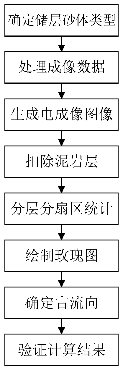
[0046] (2) Processing imaging data:

[0047] Obtain the original electrical imaging logging data of the measured well, and first correct the measured azimuth curve; the magnetic declination at the point where the well is located is -2.63°, and the longitude difference between the calculation point and the central meridian is 1.88° , the latitude of the calculation point is 3...

Embodiment 2

[0068] This embodiment relates to a method for verifying the measurement results of Example 1. First, the well contains coring data, figure 2 The winning number 1 is the coring position. The full-diameter rock core is used to make the cake-shaped rock sample and the standard plunger sample, and then the orientation of the rock sample is determined by remanent magnetism redirection; the cake-shaped rock sample is divided into 24 sectors, each Cut a flat section on the side of each sector, measure and calculate the conductivity of each group of relative sectors, and draw the results in polar coordinates, as shown in Figure 4 Shown in the middle mark 7; use the standard plunger sample to measure the core permeability, and draw the measurement result in polar coordinates according to its orientation, as shown in Figure 5 Shown in number 8; by Figure 5 The determined maximum conductivity direction and the main direction of permeability are 112.5° (or 292.5°). Comparing the res...


PUM


Abstract

The invention, which belongs to the technical field of geological structure measurement, relates to a method for measuring and determining a paleocurrent direction by using electric imaging logging. Provided in the invention is a method for analyzing and determining a paleocurrent direction of an underground reservoir stratum by using electric imaging logging data. Electric imaging logging data are processed; sub-layer sub-section statistics is carried out on the data; and a paleocurrent direction is determined based on a chart after statistic processing. To be specific, the method comprises the following steps of determining a reservoir sand body type, processing imaging data, generating an electrical imaging image, deducting a mudstone layer, carrying out sub-layer sub-section statistics, drawing a rose diagram, determining a paleocurrent direction, and verifying a calculation result. Because the paleocurrent direction is determined by using the electric imaging logging data, a phenomenon that lots of time is spent in identifying and picking up lots of geologic features by a manual method in an electrical imaging graph is avoided; various restrictions of the field exposure observation are eliminated; the measurement process principle is scientific and reliable; the measurement accuracy is high; the intelligent degree of computer processing is high; lots of manpower and properties are saved; the processing speed is fast; and the application environment is friendly.

Description

[0001] Technical field: [0002] The invention belongs to the technical field of geological structure measurement, and relates to a method for measuring paleo-flow direction by electrical imaging logging, in particular to a method of using pre-processed electrical imaging logging data, and then layering and sectorizing data statistical results A technical scheme for determining the paleoflow direction of channel-type sandbody reservoirs. [0003] Background technique: [0004] In the field of petroleum geological exploration technology, paleocurrent direction analysis and determination is one of the important means to analyze the sedimentary environment and sedimentary system of the research block. The paleocurrent direction determines the main source direction and diffusion direction of sediments in a certain period. It is related to the distribution of sand bodies and the distribution of sedimentary systems, and is of great significance for predicting the distribution range o...

Claims


Application Information

Patent Timeline
Patent Type & Authority Patents(China)
IPC IPC(8): G01V3/18
CPCG01V3/18
Inventor 张鹏云孙建孟张晋言成志刚
Owner CHINA UNIV OF PETROLEUM (EAST CHINA)
Learn More