
Method and system for architectural surveying and mapping based on projection principle
A principle and architectural technology, applied in the field of architectural surveying and mapping based on the principle of projection, can solve the problems of climbing measurement safety hazards, high cost, high cost of laser scanning equipment and accurate positioning points, etc., and achieve the effect of avoiding safety hazards
- Summary
- Abstract
- Description
- Claims
- Application Information
AI Technical Summary
Problems solved by technology
Method used
Image

Examples
Embodiment Construction
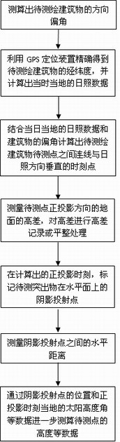
[0035] A method for architectural surveying and mapping based on projection principles, comprising the following steps:
[0036] The Dacheng Hall of a Confucian Temple in a certain place is the main hall of the Confucian Temple. It is a beam-lifting building with double eaves and Xieshan. The cornice of the building has a large arc, and laser range finders and other instruments cannot find suitable reflection points; the ridge is located higher. And there are two eaves blocking, it is difficult to measure the height and distance accurately without going to the roof.
[0037] Step 1: Survey and map the base plane of Dacheng Hall: Dacheng Hall is a place for offering sacrifices to Confucius. According to the shape of ancient buildings, it is north-south. After on-site measurement, the central axis of the building is calculated to be 20 degrees north by west;
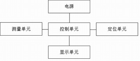
[0038] Step 2: With the help of GPS positioning device and map, the coordinates of Dacheng Hall are 112.928013 east long...
PUM
 Abstract
Description
Claims
Application Information