Building surveying and mapping method and system based on projection principle

A principle and architectural technology, applied in the field of architectural surveying and mapping based on the projection principle, which can solve the problems of hidden dangers of climbing measurement, high cost of laser scanning equipment, accurate positioning of points, and difficulty in guaranteeing the accuracy of measurement, and achieve the effect of eliminating hidden dangers.

Active Publication Date: 2019-01-18
HUNAN INSTITUTE OF ENGINEERING
View PDF7 Cites 2 Cited by
  • Summary
  • Abstract
  • Description
  • Claims
  • Application Information

AI Technical Summary

Problems solved by technology

[0003] However, some buildings, such as traditional Chinese buildings, have more protrusions (such as cornices, bucket arches, etc.), making surveying and mapping more difficult
In the existing conventional surveying and mapping methods, such as measuring tools such as tape measure, people need to climb on the roof or beams to measure, but traditional buildings are often cultural relics protection units that need to be protected, and frequent climbing is not allowed, and many buildings are old. It has been in disrepair for a long time, and there are potential safety hazards in climbing measurement; at the same time, because traditional buildings have more curved surfaces, it is difficult for long-distance measuring instruments such as laser range finders to find suitable reflection points and cannot read; use optical theodolite, total station, etc. Measurement is not only costly, but it is also difficult to fix reflection points on roofs, eaves, etc.; laser scanning equipment is not only costly, but also difficult to guarantee the accuracy of measurement in the absence of more accurate positioning points
[0004] To sum up, the current conventional measurement methods are still unable to achieve low-cost, safe and convenient measurement of curved surfaces and prominent irregular shapes in traditional and other ancient buildings.

Method used


Image

  • Building surveying and mapping method and system based on projection principle
  • Building surveying and mapping method and system based on projection principle

Examples


Embodiment Construction

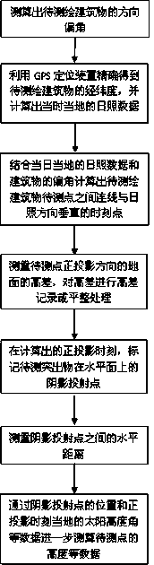
[0035] A method for architectural surveying and mapping based on projection principles, comprising the following steps:

[0036] The Dacheng Hall of a Confucian Temple in a certain place is the main hall of the Confucian Temple. It is a beam-lifting building with double eaves and Xieshan. The cornice of the building has a large arc, and laser range finders and other instruments cannot find suitable reflection points; the ridge is located higher. And there are two eaves blocking, it is difficult to measure the height and distance accurately without going to the roof.

[0037] Step 1: Survey and map the base plane of Dacheng Hall: Dacheng Hall is a place for offering sacrifices to Confucius. According to the shape of ancient buildings, it is north-south. After on-site measurement, the central axis of the building is calculated to be 20 degrees north by west;

[0038] Step 2: With the help of GPS positioning device and map, the coordinates of Dacheng Hall are 112.928013 east long...


PUM


Abstract

The invention provides a building surveying and mapping method and system based on a projection principle. According to the method, the projection principle is taken as the basis, a GPS positioning system is used for auxiliary computation of an orthographic projection time and a solar altitude at a given time and place, and the data measurement of the horizontal distance, height and the like of irregular points, surfaces and the like on the same horizontal elevation of abuilding is achieved by measuring the position of a plane projection point based on this.

Description

technical field [0001] The invention relates to a method and system for architectural surveying and mapping based on the principle of projection, especially for the surveying and mapping of traditional buildings with many curved surfaces and prominent irregular shapes and other ancient buildings. Background technique [0002] The surveying and drawing work of buildings is a necessary preliminary work for building renovation or protection. In conventional surveying and mapping work, the commonly used technical means are: 1. Distance measurement with tape measure, tape measure, plumb weight, rope, etc.; 2. Distance measurement and angle calculation with laser equipment such as laser range finder; 3. Optical theodolite , total station, etc. for fixed-point coordinate measurement; 4. With the aid of laser scanning equipment for facade surveying and mapping, etc. [0003] However, some buildings, such as traditional Chinese buildings, have more protrusions (such as cornices, buc...

Claims


Application Information

Patent Timeline
Patent Type & Authority Applications(China)
IPC IPC(8): G01C15/00G01S19/42
CPCG01C15/00G01S19/42
Inventor 成书珊李亚玲谢晶
Owner HUNAN INSTITUTE OF ENGINEERING
Why Eureka
Try Eureka