Satellite remote sensing precipitation refined space estimation method and system

A satellite remote sensing and fine-grained technology, applied in the field of remote sensing image processing, can solve problems such as limited ability to describe spatial precipitation and complex causes of precipitation, and achieve the effect of improving spatial resolution, increasing spatial resolution, and improving accuracy

Pending Publication Date: 2021-02-05
STATE GRID HUNAN ELECTRIC POWER +2
View PDF3 Cites 8 Cited by
  • Summary
  • Abstract
  • Description
  • Claims
  • Application Information

AI Technical Summary

Problems solved by technology

At present, a large number of scholars at home and abroad have carried out a lot of research in this field, and the field of precipitation information fusion has also been greatly developed. However, the causes of precipitation are complex and will be interfered by many factors such as water vapor conditions, atmospheric circulation, vegetation conditions, and even human activities. , has obvious spatial non-stationarity, especially under the influence of complex terrain, the ability to describe spatial precipitation is still limited, and efforts are still needed to explore and research related fields

Method used


Image

  • Satellite remote sensing precipitation refined space estimation method and system
  • Satellite remote sensing precipitation refined space estimation method and system
  • Satellite remote sensing precipitation refined space estimation method and system

Examples


Embodiment 1

[0032] This embodiment discloses a refined spatial estimation method of precipitation based on remote sensing precipitation products of Fengyun-4 satellite.

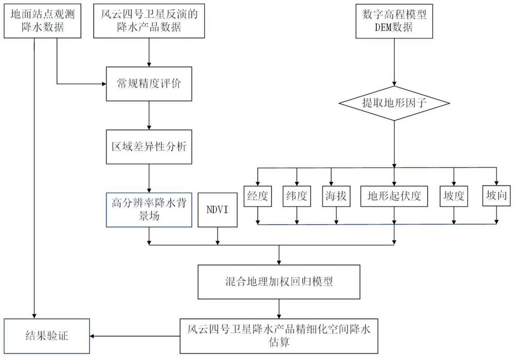
[0033] Such as figure 1 Shown, the present embodiment method comprises the following steps:

[0034] Step 1: Analyze the correlation coefficient between the annual precipitation (spatial resolution 5km×5km, target variable) and each influencing factor (spatial resolution 1km×1km) of the precipitation products of the regional Fengyun-4 satellite in Hunan Province, using stepwise linear regression method Filter out the set of explanatory variables. Wherein, the influencing factors of this embodiment include seven influencing factors such as longitude, latitude, altitude, slope, aspect, terrain relief and normalized difference vegetation index NDVI; except NDVI, other influencing factors can be obtained from the digital elevation model DEM respectively. The corresponding terrain factors are extracted from the data.

[00...

Embodiment 2

[0064] This embodiment discloses a satellite remote sensing precipitation refinement spatial estimation system, including a memory, a processor, and a computer program stored in the memory and operable on the processor, and the processor implements the following steps when executing the computer program :

[0065] Step S1, analyze the correlation coefficient between the satellite annual precipitation data and each influencing factor, and use the stepwise linear regression method to screen out the explanatory variable set. The influencing factors include longitude, latitude, altitude, slope, slope aspect, terrain relief and normalized difference vegetation index.

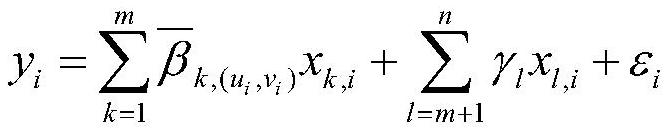
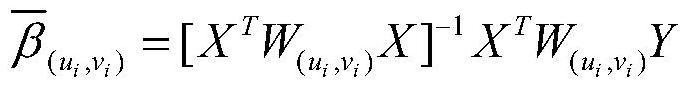
[0066] Step S2. Taking satellite precipitation as the dependent variable and the selected explanatory variable set as the explanatory variable, the regression analysis is performed using a hybrid geographically weighted regression model that integrates least squares global regression and geographically weighted regre...


PUM


Abstract

The invention relates to the field of remote sensing image processing, and discloses a satellite remote sensing precipitation refined space estimation method and system, so as to meet the requirementsof improving the spatial resolution and maintaining the data accuracy at the same time. The method comprises the steps of analyzing correlation coefficients between satellite annual precipitation data and all influence factors, and screening out an explanatory variable set through a stepwise linear regression method; taking satellite precipitation as a dependent variable, taking the screened explanatory variable set as an explanatory variable, carrying out regression analysis by adopting a hybrid geographically weighted regression model fusing least square method global regression and geographically weighted regression, and obtaining high-resolution regression trend surface spatial data according to a calculation result of a regression coefficient; carrying out interpolation on the regression residual error by adopting a common Kriging interpolation method to obtain residual error interpolation space data; and adding the regression trend surface and the residual interpolation spatialdata, and performing downscaling conversion according to the target spatial resolution to obtain estimated satellite annual precipitation data.

Description

technical field [0001] The invention relates to the field of remote sensing image processing, in particular to a satellite remote sensing precipitation refinement spatial estimation method and system. Background technique [0002] As a key link in the global atmospheric and water cycle, precipitation is of great significance in the fields of meteorology, agriculture, and the environment. It can provide effective data support for agricultural production, water resource management, ecological environment governance, and disaster prevention and mitigation. In theory, spatial precipitation data can be obtained through spatially discrete meteorological stations and hydrological stations, but it must be established on the condition that the density of meteorological or hydrological stations is sufficiently large and the distribution is uniform enough. As the largest developing country in the world, although China has a large number of meteorological and hydrological stations, comp...

Claims


Application Information

Patent Timeline
Patent Type & Authority Applications(China)
IPC IPC(8): G06F30/20
CPCG06F30/20
Inventor 章国勇冯文卿何立夫罗晶郭俊
Owner STATE GRID HUNAN ELECTRIC POWER
Why Eureka
Try Eureka