Method for measuring terrain of coastal shallow water area by using a low-altitude unmanned aerial vehicle

A technology for unmanned aerial vehicles and shallow water areas. It is applied in the directions of measuring instruments, measuring devices, surveying and navigation, etc. It can solve the problems that cannot meet the requirements of large-scale underwater terrain measurement, the difficulty of engineering application, and the complicated calculation process. Solve the problem of fast and high-precision measurement, improve accuracy and reliability, and enrich the effect of texture information

Active Publication Date: 2021-07-27
TIANJIN SURVEY & DESIGN INST OF WATER TRANSPORT ENG +1
View PDF7 Cites 4 Cited by
  • Summary
  • Abstract
  • Description
  • Claims
  • Application Information

AI Technical Summary

Problems solved by technology

The calculation process of water depth inversion from multispectral images is complex and the accuracy is low, which cannot meet the requirements of large-scale underwater topographic survey
Stereo image dual-media measurement of water depth has more theoretically studied the feasibility of this method, but the calculation process is also complicated, the steps are cumbersome, and engineering application is very difficult

Method used


Image

  • Method for measuring terrain of coastal shallow water area by using a low-altitude unmanned aerial vehicle
  • Method for measuring terrain of coastal shallow water area by using a low-altitude unmanned aerial vehicle
  • Method for measuring terrain of coastal shallow water area by using a low-altitude unmanned aerial vehicle

Examples


Embodiment Construction

[0024] In order to further understand the invention content, characteristics and effects of the present invention, the following examples are given, and detailed descriptions are as follows in conjunction with the accompanying drawings:

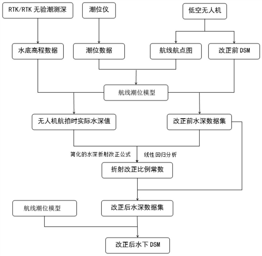
[0025] see figure 1 , a method for surveying the topography of shallow coastal waters using low-altitude UAVs, using the following steps:

[0026] Step 1: According to the tidal law and position distribution along the coast of the survey area, set up tide gauges to obtain tide level data in the survey area; use low-altitude UAVs to obtain images of the survey area, and obtain underwater DSM (Digital Surface Model) and route navigation data after processing. point map.

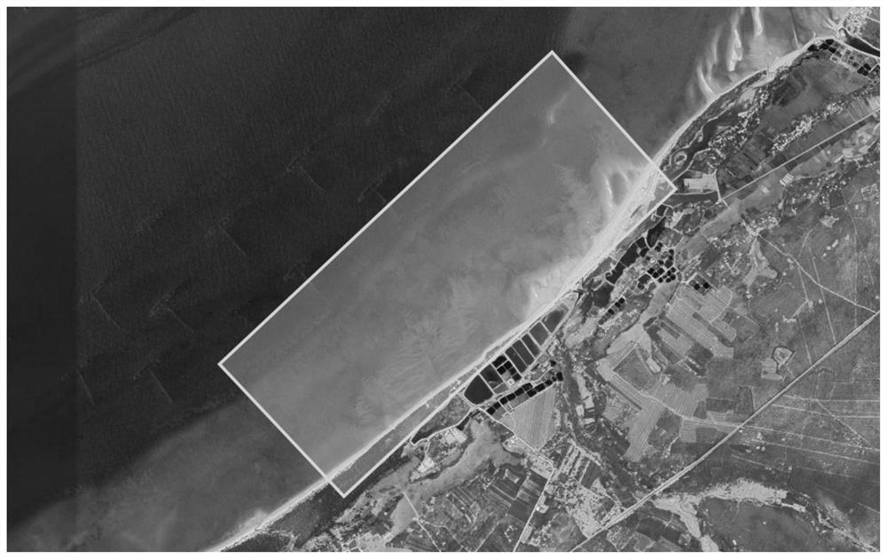
[0027] Typical coastal shallow water areas such as figure 2 , the water quality is relatively clear, the bottom of the water is clearly visible, and the maximum water depth is less than 3m. According to the tidal law along the coast of the survey area, a tide level meter is...


PUM


Abstract

The invention discloses a method for measuring the terrain of a coastal shallow water area by using a low-altitude unmanned aerial vehicle. The method comprises the following steps: 1, obtaining tide level data of a measured area; using a low-altitude unmanned aerial vehicle for obtaining a measuring area image, and obtaining an underwater digital earth surface model and a route waypoint diagram before correction after processing; 2, generating a route tide level model; 3, obtaining a water depth data set before correction; 4, obtaining actual water depth data h water depth at a corresponding position during aerial survey of the unmanned aerial vehicle; 5, substituting multiple pairs of h water depth and h before correction into a simplified water depth refraction correction formula h water depth = k * h before correction, and obtaining a refraction correction proportion constant k; 6, multiplying the water depth data set before correction by a refraction correction proportion constant k to obtain a water depth data set after correction; and 7, performing one-to-one correspondence subtraction on the route tide level model and the corrected water depth data set to obtain shallow water area underwater topographic data. According to the invention, rapid and high-precision measurement of the coastal shallow water terrain can be realized.

Description

technical field [0001] The invention relates to the field of marine surveying and mapping, in particular to a method for measuring the topography of coastal shallow water areas by using a low-altitude unmanned aerial vehicle. Background technique [0002] Underwater topographic surveying is a basic work of marine surveying and mapping, and it is also a specific survey in engineering surveying. Mapping work. Underwater topographic survey is the first step in exploring and researching and developing and protecting oceans and other waters. It is of great significance for mastering the law of terrain evolution, hydraulic construction and military research. Conventional underwater topographic surveys generally use single-beam or multi-beam depth sounders, both of which depend on the ship, and have certain restrictions on the shallowest water depth in the survey area. When measuring coastal shallow water areas, affected by tides and water depth, it is easy to Stranding, rocking,...

Claims


Application Information

Patent Timeline
Patent Type & Authority Applications(China)
IPC IPC(8): G01C11/04G01C11/02G01C15/00
CPCG01C11/04G01C11/02G01C15/00Y02A90/30
Inventor 刘亮熊伟刘昔李全荣侯秋实
Owner TIANJIN SURVEY & DESIGN INST OF WATER TRANSPORT ENG
Why Eureka
Try Eureka