Process for managing the representation of at least one 3D model of a scene

a 3d model and scene technology, applied in the field of scene management, can solve the problems of not being able to adapt to visualising realistic urban scenes, affecting the quality of scene representation, etc., and achieve the effect of reducing the number of images

Inactive Publication Date: 2005-01-20
FRANCE TELECOM SA
View PDF1 Cites 50 Cited by
  • Summary
  • Abstract
  • Description
  • Claims
  • Application Information

AI Technical Summary

Problems solved by technology

Several techniques have already been proposed to allow complex urban models to be visualised locally, but very few are adapted to visualising realistic urban scenes on the network.
The problem posed by this technique is the appearance of artefacts due to the parallax effects generated by perspective projection.
However, all the image-based representations have the drawback of being too bulky for transmission on the network (expensive image, mesh, or multi-point transfers).
Given the large number of buildings in a city, the size of the city database in point-based representation would be much too bulky to be stored on the server and transmitted to the customer.
In the case of a customer-server application, only the server has overall knowledge of the scene, and it is therefore on the server side that the PVS calculations will have to be made, which would give very unsatisfactory results in the event of a large number of customers being connected.
However, in the case of overflying urban scenes, the great majority of the buildings in a city are visible, and therefore the more the altitude of the viewpoint increases, the larger the PVS associated with the viewpoint become.
This technique of conservative visibility is therefore adapted to ground level navigation, but cannot be used for overflying cities.
In fact, preserving the complex geometry of an object constituted by a large number of polygons is pointless in the event of its projection in the image covering only a few pixels.
Moreover, it is not conceivable to apply simplifications to buildings taken one by one, but rather to the city in its entirety.
The University of Stuttgart's urban navigation platform Nexus uses the static levels of details for the buildings, but does not offer a progressive and dynamic multi-scale representation of a city [13].
The drawback of this representation is the lack of realism of the 3D model of the city.

Method used


Image

  • Process for managing the representation of at least one 3D model of a scene
  • Process for managing the representation of at least one 3D model of a scene
  • Process for managing the representation of at least one 3D model of a scene

Examples


Embodiment Construction

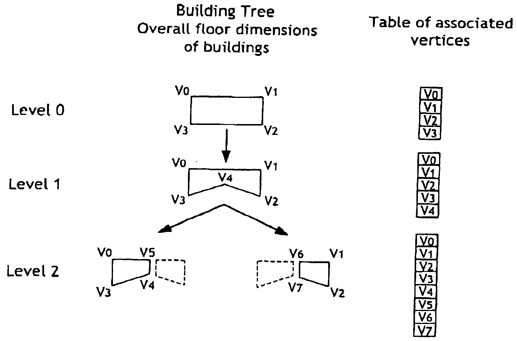
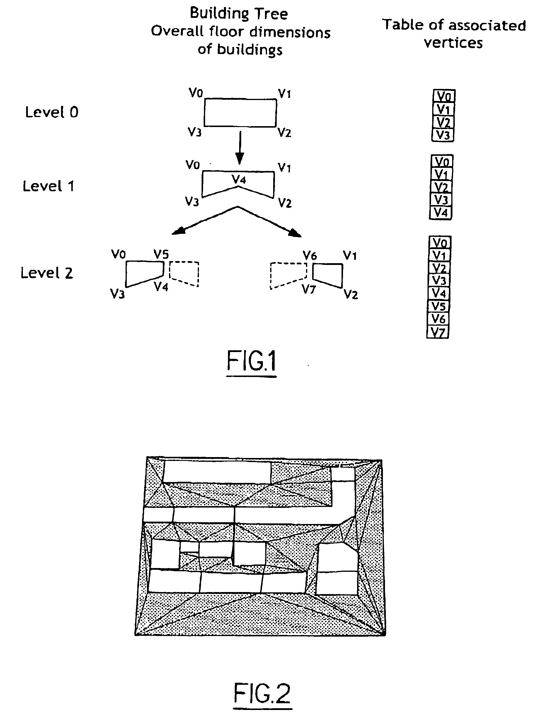
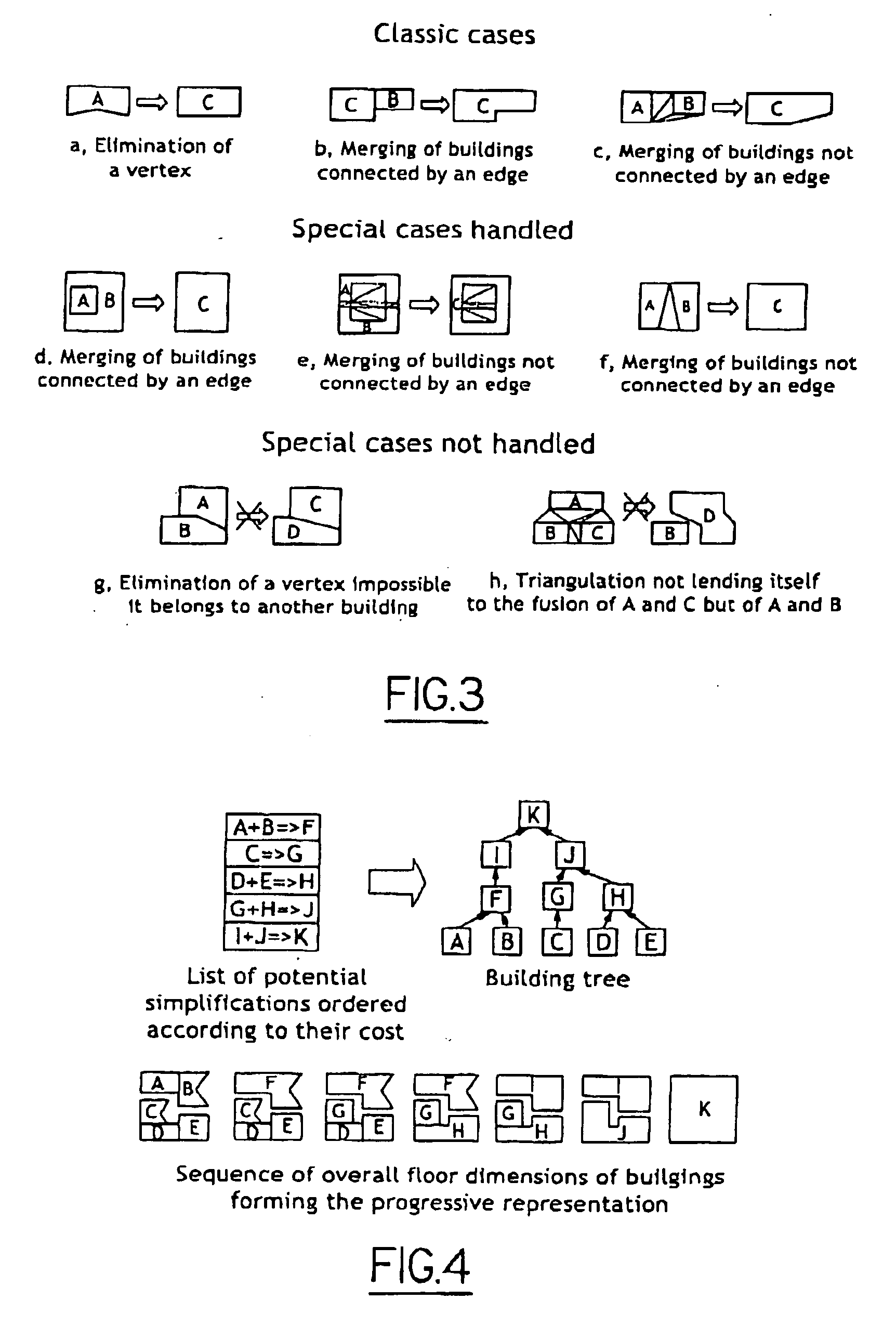
In this section is given the 2D1 / 2 informations representing all the buildings provided by most of the algorithms for modelling a city automatically, thus allowing the progressive multi-scale representation implemented to be specified.

Then the algorithm is given that allows this progressive multi-scale representation to be generated.

Lastly, we propose an example of use of this representation on a visualisation and navigation system in vast urban environments on networks.

1 2D1 / 2 Representation of Buildings in a City

A city cannot be modelled manually given the substantial number of buildings of which it is made up. Most automatic city modelling techniques make it possible, from 2D1 / 2 information (videos, photographs, cadastral maps, etc), to extract the necessary 2D1 / 2 information allowing the 3D model of the city to be reconstructed by extrusion (segmentation of the image determining the overall floor dimensions of the buildings and techniques derived from photogrammetry pro...


PUM


Abstract

Process for managing the representation of at least one model of a scene including buildings intended to be transmitted by storage means to a client, said scene being modelled by a multi-scale tree-structured representation, in which different nodes are associated with the different levels of details of the scene, these different nodes being dependent on each other in a tree structure in which at least one son node is defined by informations known by a father node and by additional informations, the informations stored by the storage means in respect of the son node being these additional informations, characterised in that a processing operation to simplify the representation is applied to the modelling and in that priorities for implementing the simplification processing operations are determined by determining a cost function which takes account of the criterion of the difference in height of the merged buildings.

Description

The present invention relates to the representation of at least one 3-D model of a scene. It is particularly advantageous when applied to transmitting and visualising buildings via the network. GENERAL TECHNICAL FIELD Over recent years, several techniques have made it possible to model vast urban environments automatically from 2D1 / 2 informations. Among these techniques may be cited image segmentation combined with methods derived from photogrammetry, which allow the altitude, height, and roof type of a building to be determined from a video or from aerial photographs, or again the use of geographical information systems (cadastral maps, aerial images, etc.). From this 2D1 / 2 representation, comparable to a series of parameterisable prisms, a 3D model is reconstructed, allowing navigation within this city. Other methods using laser scanners provide 3D models of cities that are much more detailed, but have the drawback of providing a multitude of unstructured elements (due to occlu...

Claims


Application Information

Patent Timeline
Patent Type & Authority Applications(United States)
IPC IPC(8): G06T17/00
CPCG06T17/005G06F17/5004G06F30/13
Inventor ROYAN, JEROME
Owner FRANCE TELECOM SA
Why Eureka
Try Eureka