Road survey and design method based on high-resolution satellite image

A satellite image, high-resolution technology, applied in the direction of measuring devices, electromagnetic wave re-radiation, radio wave measurement systems, etc., can solve the problems of lack of practicability, function, quantity and distribution, and can not meet the requirements of road design, etc., to achieve Significant economic and social benefits, reduced field workload, and shortened survey and design cycle

Active Publication Date: 2010-08-25
CCCC SECOND HIGHWAY CONSULTANTS CO LTD
View PDF4 Cites 29 Cited by
  • Summary
  • Abstract
  • Description
  • Claims
  • Application Information

AI Technical Summary

Problems solved by technology

In areas with inconvenient transportation and harsh environments, it is often difficult or even impossible to obtain ground control points
[0004] Second, aerial photography is difficult
The function, quantity and distribution of control points are not explained, which cannot meet the requirements of road design, especially the requirements of road survey and design in difficult and complex areas
[0009] 2. Lack of practicability, cumbersome process and low efficiency
Generating digital elevation models and digital orthophotos twice is not only cumbersome, but also greatly affects work efficiency and practical operability
[0010] 3. Lack of accuracy indicators
There is no description of the actual accuracy of satellite image generation products, and it is impossible to determine which road survey and design stage is applicable

Method used


Image

  • Road survey and design method based on high-resolution satellite image
  • Road survey and design method based on high-resolution satellite image
  • Road survey and design method based on high-resolution satellite image

Examples


Embodiment 1

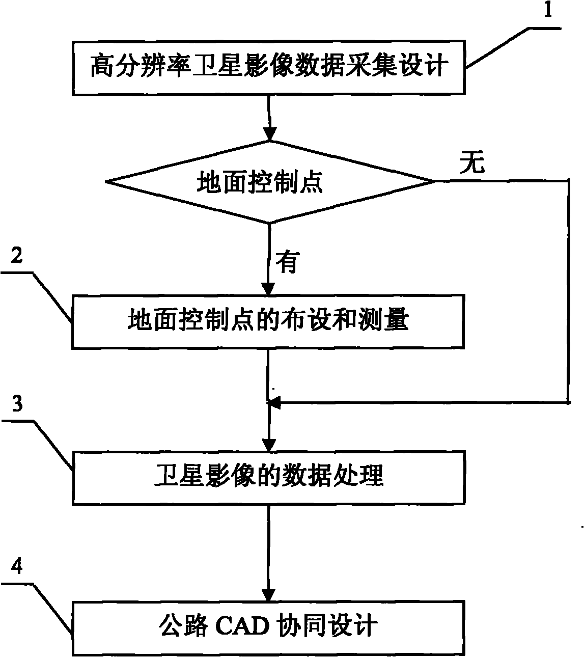
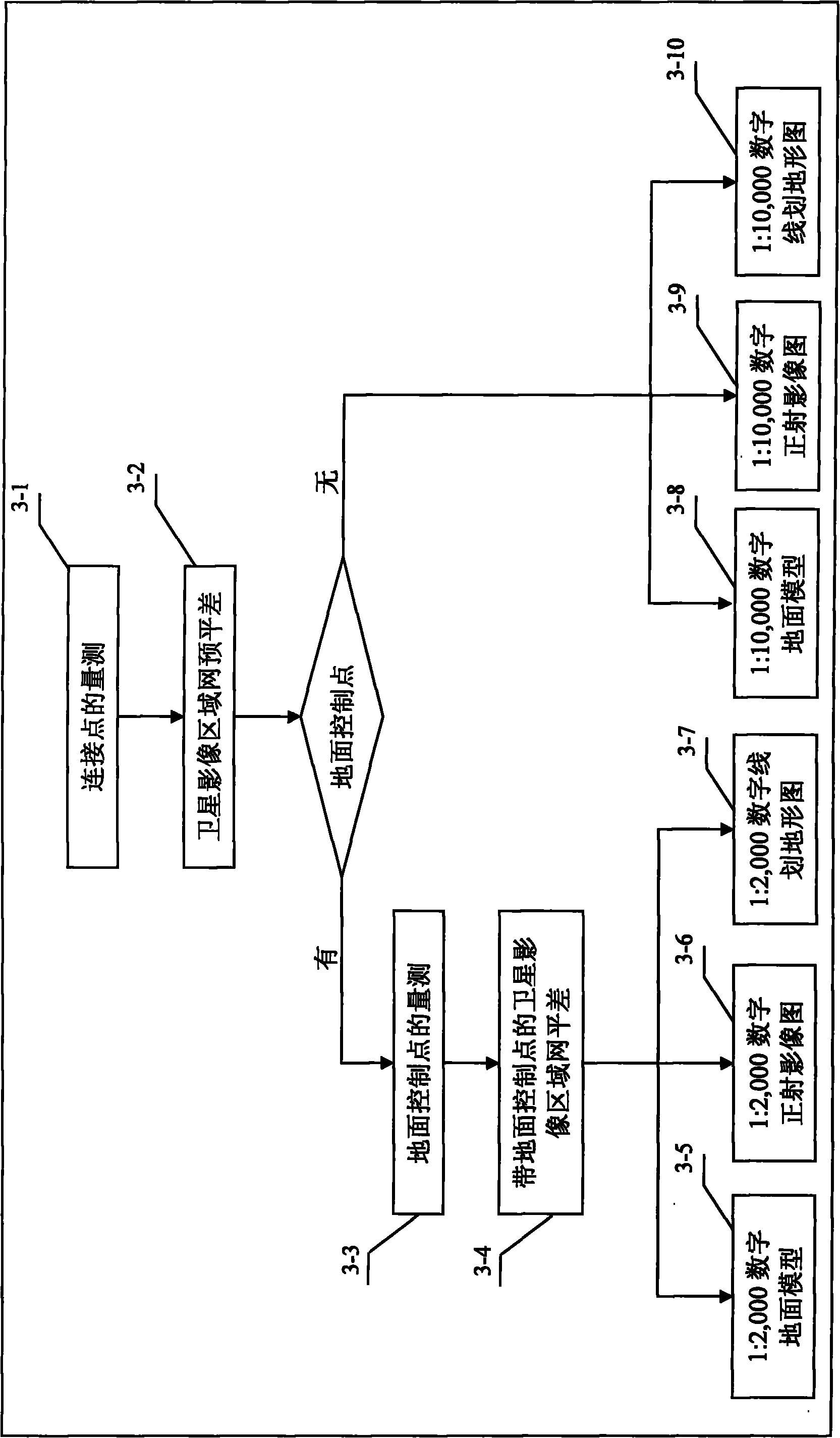
[0032] The present invention will be described in further detail below in conjunction with the accompanying drawings. A road survey and design method based on high-resolution satellite imagery, each step is described in detail as follows:

[0033] The first step, high-resolution satellite imagery data acquisition design 1

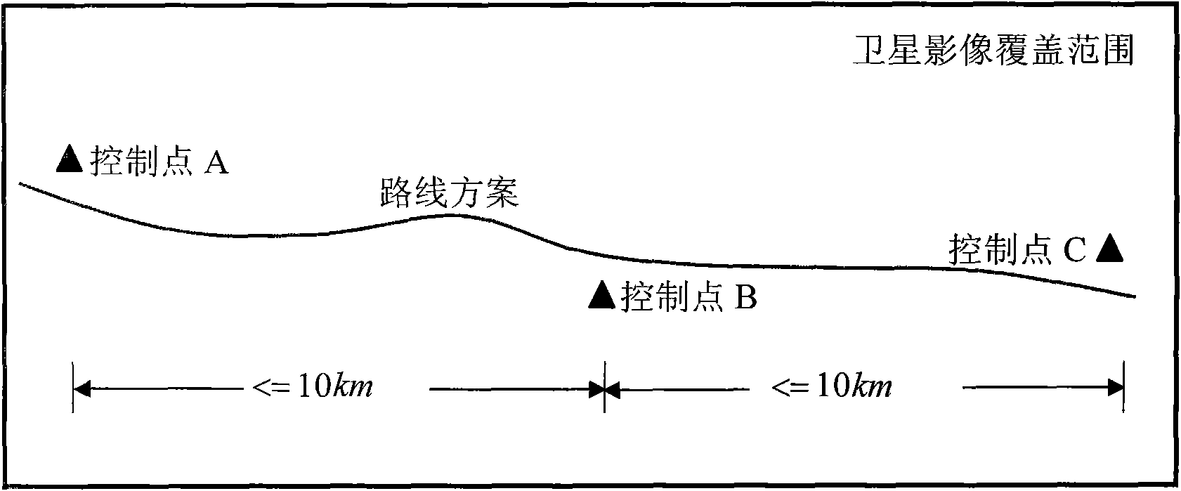
[0034] 1. Determination of collection range. On the 1:50,000 topographic map, mark the route plan (including the comparison plan) or the scope of the corridor of the scheme and the areas with special requirements; the collection range should cover all possible schemes or the scope of the corridor; the width should be at least 5km.

[0035] 2. Selection of high-resolution satellites and sensors. Choose from high-resolution satellites and sensors such as WorldView, Geoeye, and IKONOS.

[0036] 3. Choose the scanning method. In addition to the normal scanning method, use the side swing capability of the satellite and the attitude change of the sensor as mu...


PUM


Abstract

The invention discloses a road survey and design method based on a high-resolution satellite image, which comprises the following steps: A, determining a scope to be covered by a satellite image according to a route scheme, selecting a high-resolution satellite and a sensor for collection, and designing and collecting three-dimensional images of the high-resolution satellite; B, when a scale of 1 to 2,000 is formed, laying and measuring field ground control points and laying control points along the route; C, generating a digital ground model, a digital orthophotomap and a digital line topographic map for the road route area through area adjustment of the three-dimensional images of the high-resolution satellite based on rational polynomial parameters of the images of the high-resolution satellite; and D, calculating engineering quantities and generating route design drawings and tables through measurement of the high-resolution satellite and collaborative design of the road CAD. The invention realizes the measurement of the high-resolution satellite and the collaborative design of the road CAD, thereby greatly reducing the field workload, shortening the survey and design period, and producing significant economic and social benefits.

Description

technical field [0001] The invention relates to the technical field of highway survey and design, and more specifically relates to a highway survey and design method based on long strips of high-resolution satellite images, which is suitable for highway survey and design in areas with difficult and complex surfaces or special geographical locations. Background technique [0002] At present, highway survey and design are usually based on the method of aerial photogrammetry, that is, according to the route plan, digital images with a certain degree of overlap within the scope of the route corridor are obtained through aerial photography, and then carried out on the digital photogrammetry workstation using field image control measurement results. The internal aerial triangulation is encrypted, and after data processing, digital ground models, digital orthophoto maps, digital line-drawn topographic maps and other products are obtained, and road route design is carried out on this...

Claims


Application Information

Patent Timeline
Patent Type & Authority Applications(China)
IPC IPC(8): G06F17/50G01S17/89
Inventor 陈楚江明洋余绍淮张霄王丽园梁诚
Owner CCCC SECOND HIGHWAY CONSULTANTS CO LTD
Why Eureka
Try Eureka