A Method for Layout of Low Altitude Photogrammetry Image Control Points in a Strip Survey Area

A photogrammetry and image control point technology, applied in the direction of photo interpretation, etc., can solve the problems of inconvenient implementation of elevation control point spacing, large field workload, and incomplete rationality, so as to reduce field workload and labor intensity. , to avoid the effect of excessive construction difficulty

Active Publication Date: 2019-06-07
CHINA MAJOR BRIDGE ENERGINEERING
View PDF1 Cites 0 Cited by
  • Summary
  • Abstract
  • Description
  • Claims
  • Application Information

AI Technical Summary

Problems solved by technology

Obviously, the distance between the elevation control points estimated from this is not easy to implement, the workload in the field is too large, the measurement is difficult, and in fact it is not completely reasonable

Method used


Image

  • A Method for Layout of Low Altitude Photogrammetry Image Control Points in a Strip Survey Area
  • A Method for Layout of Low Altitude Photogrammetry Image Control Points in a Strip Survey Area
  • A Method for Layout of Low Altitude Photogrammetry Image Control Points in a Strip Survey Area

Examples


Embodiment Construction

[0043] The present invention will be described in further detail below in conjunction with the accompanying drawings and embodiments.

[0044] see figure 1 As shown, the embodiment of the present invention provides a method for laying out low-altitude photogrammetry image control points in a belt-shaped survey area, including the following steps:

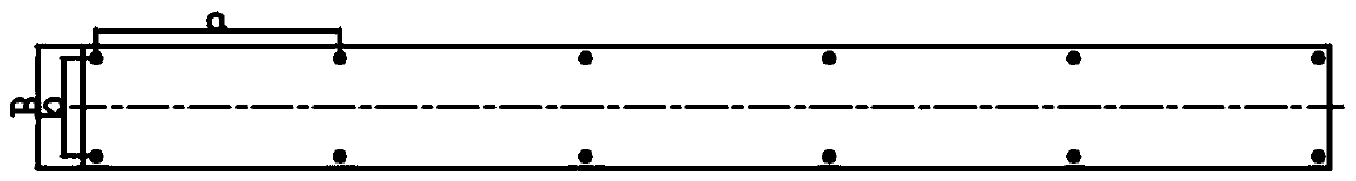
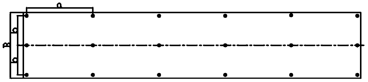
[0045] S1. Determine the bandwidth and length of the area to be measured, the terrain type (flat land, hilly land, mountainous area, and high mountain area), forest vegetation coverage, and water area distribution.

[0046] According to different project construction stages and project requirements, determine the surveying scale according to relevant specifications: 1:500, 1:1000 or 1:2000.

[0047] According to the industry standard, the mapping accuracy is determined according to the topographic category of the area to be measured and the mapping scale. Among them, the mapping accuracy includes the plane position error and elevat...


PUM


Abstract

The invention discloses a photo-control-point survey method through strip-shaped testing area low-altitude photogrammetry and relates to the technical field of photogrammetry. The method comprises the following steps: determining mapping accuracy according to strip width, strip length and terrain category of a to-be-tested area and a mapping scale; determining a course point distance a and a lateral point distance b of the photo-control point according to the terrain category, the strip width, the mapping scale and the mapping accuracy of the to-be-tested area; symmetrically arranging one row or a plurality of rows of photo-control points on the left and right sides parallel to central lines of track, and arranging landmarks; measuring the coordinates and heights of the photo-control points by using a total station, a level gage or a GNSS RTK method. According to the method disclosed by the invention, the quantity and position of reasonable photo-control points can be determined according to actual conditions, the condition that the construction difficulty is extremely high due to excessively dense photo-control points can be avoided, the field workload can be alleviated, the labor intensity is reduced, and the construction period is shortened. Meanwhile, the problem that the mapping accuracy cannot meet the specified requirement due to extremely low density of the photo-control points is solved.

Description

technical field [0001] The invention relates to the technical field of photogrammetry, in particular to a method for laying out image control points for low-altitude photogrammetry in a belt-shaped survey area. Background technique [0002] Traditional large aircraft aerial photogrammetry has disadvantages such as long flight time, poor maneuverability, low real-time performance, high cost, limited accuracy, and not suitable for dangerous areas. The rapid development of UAV low-altitude digital aerial photogrammetry technology in recent years makes up for it It overcomes the shortcomings of traditional manned aerial survey, and is gradually becoming an effective supplementary means for satellite remote sensing, manned and ground remote sensing, especially suitable for quickly obtaining large-scale digital maps with high precision in small areas and difficult to fly areas. However, UAV aerial survey images have a smaller image size and more image pairs, and the image quality ...

Claims


Application Information

Patent Timeline
Patent Type & Authority Patents(China)
IPC IPC(8): G01C11/34
CPCG01C11/34
Inventor 吴迪军熊伟何广源潘飞李剑坤谢坤吴珍丽李书银薛万唱
Owner CHINA MAJOR BRIDGE ENERGINEERING
Why Eureka
Try Eureka