Mutual-inspection and temporal fusion method for surface subsidence monitoring result of PSInSAR for lifting track

A land subsidence and time series fusion technology, which is applied in surveying and navigation, measuring devices, height/horizontal measurement, etc., can solve the problems of spatial position deviation, reduced PSInSAR measurement accuracy, and reduced timeliness of observation values, etc.

Inactive Publication Date: 2014-10-22
CHINA AERO GEOPHYSICAL SURVEY & REMOTE SENSING CENT FOR LAND & RESOURCES
View PDF3 Cites 27 Cited by
  • Summary
  • Abstract
  • Description
  • Claims
  • Application Information

AI Technical Summary

Problems solved by technology

[0007] Theoretically speaking, the accuracy of PSInSAR to measure surface deformation can reach the submillimeter level, but in the process of data processing, the number of radar images used, the distance between PS points and reference points, the reliability of phase unwrapping, and the atmospheric influence The size and size of PSInSAR will reduce the measurement accuracy of PSInSAR. Therefore, objectively evaluating the accuracy of PSInSAR measurement results and measuring the reliability of

Method used


Image

  • Mutual-inspection and temporal fusion method for surface subsidence monitoring result of PSInSAR for lifting track
  • Mutual-inspection and temporal fusion method for surface subsidence monitoring result of PSInSAR for lifting track
  • Mutual-inspection and temporal fusion method for surface subsidence monitoring result of PSInSAR for lifting track

Examples


Embodiment Construction

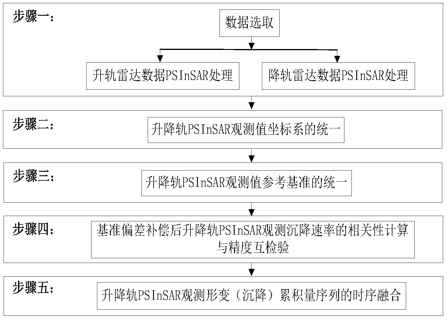
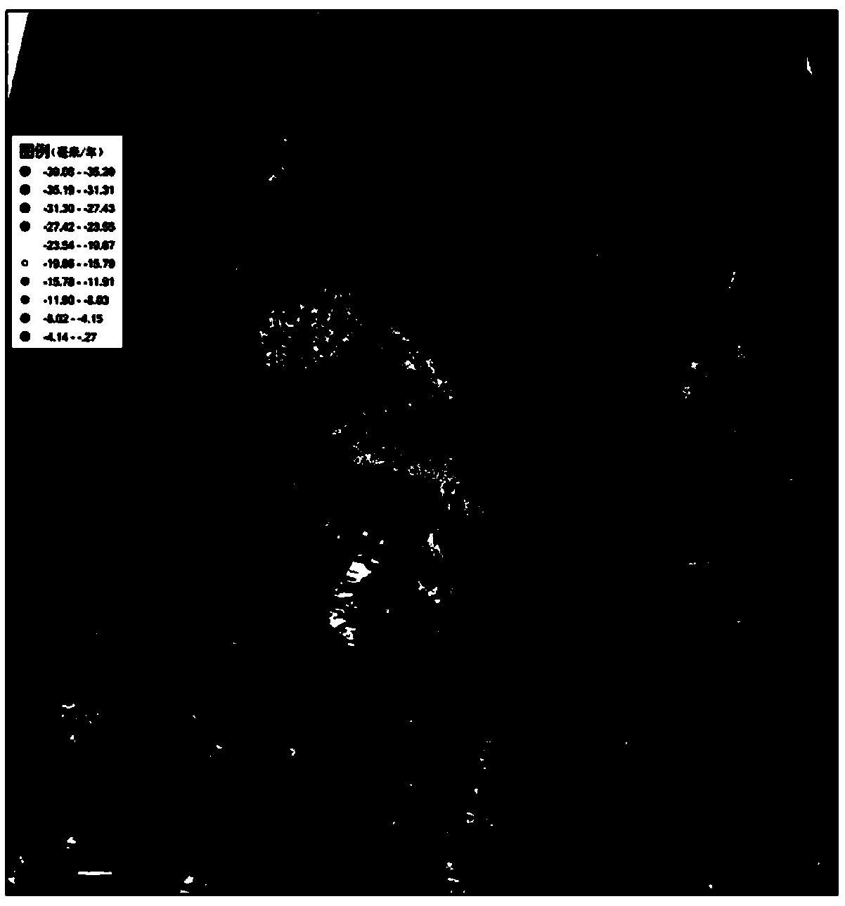
[0061] Taking the ENVISAT ascending and descending track radar data covering the northwest area of ​​Suzhou City as an example, the specific operation steps of the present invention in practical engineering application are illustrated. See figure 1 , the present invention is a method for mutual inspection and time series fusion of the PSInSAR ground subsidence monitoring results of the lifting rail. The specific steps of the method are as follows:

[0062] Step 1: Data selection and PSInSAR processing on the elevator radar data

[0063] 1. Data selection

[0064] Select multiple spaceborne synthetic aperture radar SLC images covering the work area to monitor the ground subsidence in the work area. For this purpose, the time span of the 20m resolution of the ESA ENVISAT space-borne C-band is selected as the time span from September 2006 to August 2010, and the two orbits are the 24 frames of the ascending track-39 and the descending track-275. 27 pieces of SLC data, see fi...


PUM


Abstract

The invention discloses a mutual-inspection and temporal fusion method for surface subsidence monitoring result of PSInSAR for a lifting track. The mutual-inspection and temporal fusion method for the surface subsidence monitoring result of the PSInSAR for the lifting track includes steps that 1, selecting data and carrying out PSInSAR treatment on lifting track radar data; 2, unifying PSInSAR observation value coordinate systems of the lifting track; 3, unifying PSInSAR observation value basis references of the lifting track; 4, after compensating the reference deviation, carrying out correlation calculation and mutual-precision inspection on PSInSAR observation sedimentation rates of the lifting track; 5, carrying out temporal fusion on the PSInSAR observation deformation (sedimentation accumulation sequence). The mutual-inspection and temporal fusion method for the surface subsidence monitoring result of the PSInSAR for the lifting track realizes the temporal fusion for the PSInSAR observation deformation accumulation data of main and auxiliary tracks through calculating the whole deviation of main and auxiliary track observation sequences and deformation accumulation difference caused by starting time difference and encrypts the observation deformation sequences of the PSInSAR of a research area so as to precisely and subtly restore the nonlinear dynamic change process of the surface subsidence of the research area.

Description

technical field [0001] The invention relates to a method for mutual inspection and time series fusion of PSInSAR ground subsidence monitoring results of a lifting rail, and belongs to the technical field of synthetic aperture radar interference. After the PSInSAR data processing is performed on the radar data of the ascending and descending rails, the two sets of line-of-sight deformation variables obtained are converted into settlement quantities for mutual inspection of settlement monitoring accuracy. The time-series fusion of the accumulated subsidence of coherent targets can achieve the purpose of encrypting PSInSAR to monitor the deformation sequence of land subsidence. This method can completely describe the nonlinear change process of land subsidence in the study area. Background technique [0002] PSInSAR, or permanent scatterer interferometry, is an important technique for extracting three-dimensional spatial information of ground targets based on the phase data of ...

Claims


Application Information

Patent Timeline
IPC IPC(8): G01S13/90G01S7/40
CPCG01C5/00G01S7/40G01S13/9023
Inventor 王艳葛大庆李曼张玲郭小方
Owner CHINA AERO GEOPHYSICAL SURVEY & REMOTE SENSING CENT FOR LAND & RESOURCES
Why Eureka
Try Eureka