Method for manufacturing and displaying large-scale urban space energy consumption digital map

A digital map and display method technology, which is applied in the direction of electronic digital data processing, energy-saving calculation, structured data retrieval, etc., can solve the problem of lack of large-scale urban space energy consumption, reduce errors, avoid time-consuming and laborious, and improve work efficiency effect

Active Publication Date: 2016-08-24
SOUTHEAST UNIV
View PDF5 Cites 15 Cited by
  • Summary
  • Abstract
  • Description
  • Claims
  • Application Information

AI Technical Summary

Problems solved by technology

[0004] At present, there is a lack of calculation and research on large-scale urban space energy consumption at home and abroad, and the research on energy consumption of small-scale spaces and single buildings is mainly lacking, especially the research and application of spatial positioning and distribution of space energy consumption, and even more Geographical information image display technology and inventions without coping with a large amount of spatial energy consumption data

Method used


Image

  • Method for manufacturing and displaying large-scale urban space energy consumption digital map
  • Method for manufacturing and displaying large-scale urban space energy consumption digital map
  • Method for manufacturing and displaying large-scale urban space energy consumption digital map

Examples


Embodiment

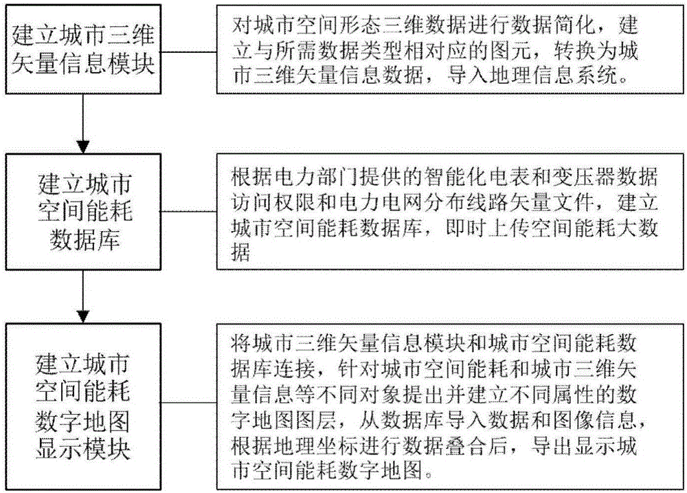
[0043] Embodiment: a method for making and displaying a digital map of large-scale urban space energy consumption, such as figure 1 As shown, it specifically includes the following operations:

[0044] 1) Establish a city three-dimensional vector information module

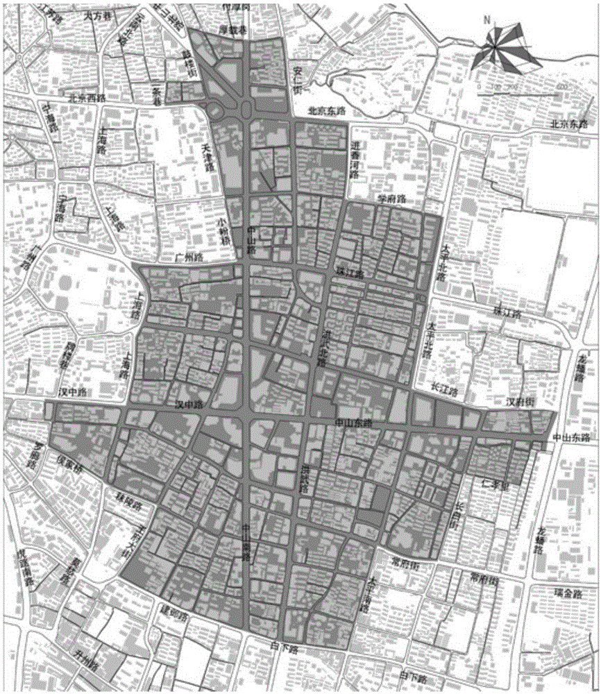
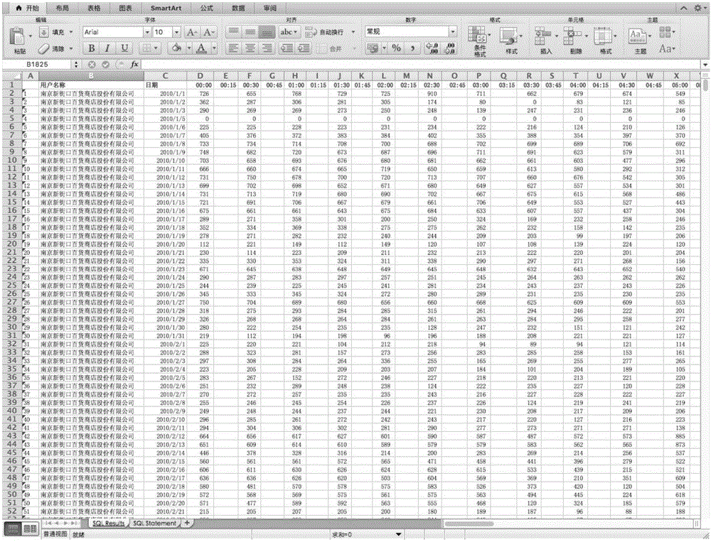
[0045] This embodiment takes the central area of ​​Nanjing as an example, such as figure 2 As shown, data simplification is carried out on the 3D data of the spatial form of the central area of ​​Nanjing, the primitives corresponding to the required data types are established, converted into urban 3D vector information data, and imported into the geographic information system.

[0046] 1.1) According to actual surveying and mapping and satellite remote sensing maps, complete and accurate vector graphics of the current land use in the central area of ​​Nanjing and related geospatial coordinate data are obtained;

[0047] 1.2) Simplify and convert the format of the three-dimensional data of the spatial form of th...


PUM


Abstract

The invention discloses a method for manufacturing and displaying a large-scale urban space energy consumption digital map. The method comprises the following steps of: performing data simplification on urban space form three-dimensional data, establishing a pixel corresponding to needed data type, converting the pixel into urban three-dimensional vector information data, and loading into a geographic information system; establishing an urban space energy consumption database, uploading space energy consumption big data immediately; connecting a three-dimensional vector information module with an urban space energy consumption database; importing data and image information from the database, performing data superimposition according to geographical coordinates, and exporting a digital map capable of displaying urban space energy consumption. According to the method, urban space energy consumption data is combined with an urban digital map system in a vector image mode, so that spatial visualization display of urban space energy consumption is realized; by virtue of the digital map, the space energy consumption condition of a whole city can be mastered; based on a cloud data technology of a computer, automatic calculation processing of urban space energy consumption mass data is realized, and time-consuming and labor-consuming manual data processing is avoided.

Description

technical field [0001] The invention relates to a method for making a digital map, in particular to a method for making and displaying a digital map of urban space energy consumption. Background technique [0002] Low-carbon cities have become the forefront of global urban development. With the rapid development of urban construction, my country's urban energy consumption has increased significantly year by year. Huge energy consumption has become a huge burden on the national economy. How to reduce urban energy consumption and use it reasonably and effectively Energy and improving energy efficiency have become important issues facing urban development at present and in the future. Urban spatial energy consumption is closely related to urban spatial form and layout, and is crucial to building low-energy cities and conducting research on spatial energy consumption in various urban land uses. Reducing urban space energy consumption is conducive to promoting energy conservation...

Claims


Application Information

Patent Timeline
Patent Type & Authority Applications(China)
IPC IPC(8): G06F17/30
CPCG06F16/29Y02D10/00
Inventor 杨俊宴陆小波
Owner SOUTHEAST UNIV
Why Eureka
Try Eureka