
A method for making and displaying a digital map of urban green quantity

A technology of urban green quantity and digital map, which is applied in the direction of still image data in vector format, geographic information database, structured data retrieval, etc., to achieve the effect of assisting planning, precise positioning, and improving data accuracy

Active Publication Date: 2019-01-29
SOUTHEAST UNIV
View PDF4 Cites 0 Cited by
  • Summary
  • Abstract
  • Description
  • Claims
  • Application Information

AI Technical Summary

Problems solved by technology

At present, there is no invention of digital map production and display of urban green quantity in China. This invention focuses on image production and display technology of digital map of urban green quantity for the first time.

Method used


Image

  • A method for making and displaying a digital map of urban green quantity
  • A method for making and displaying a digital map of urban green quantity
  • A method for making and displaying a digital map of urban green quantity

Examples


Embodiment Construction

[0045] The present invention will be further explained below in conjunction with the accompanying drawings and specific embodiments. It should be understood that these embodiments are only used to illustrate the present invention and are not intended to limit the scope of the present invention. After reading the present invention, those skilled in the art all fall into the appended claims of the present application to the amendments of various equivalent forms of the present invention limited range.

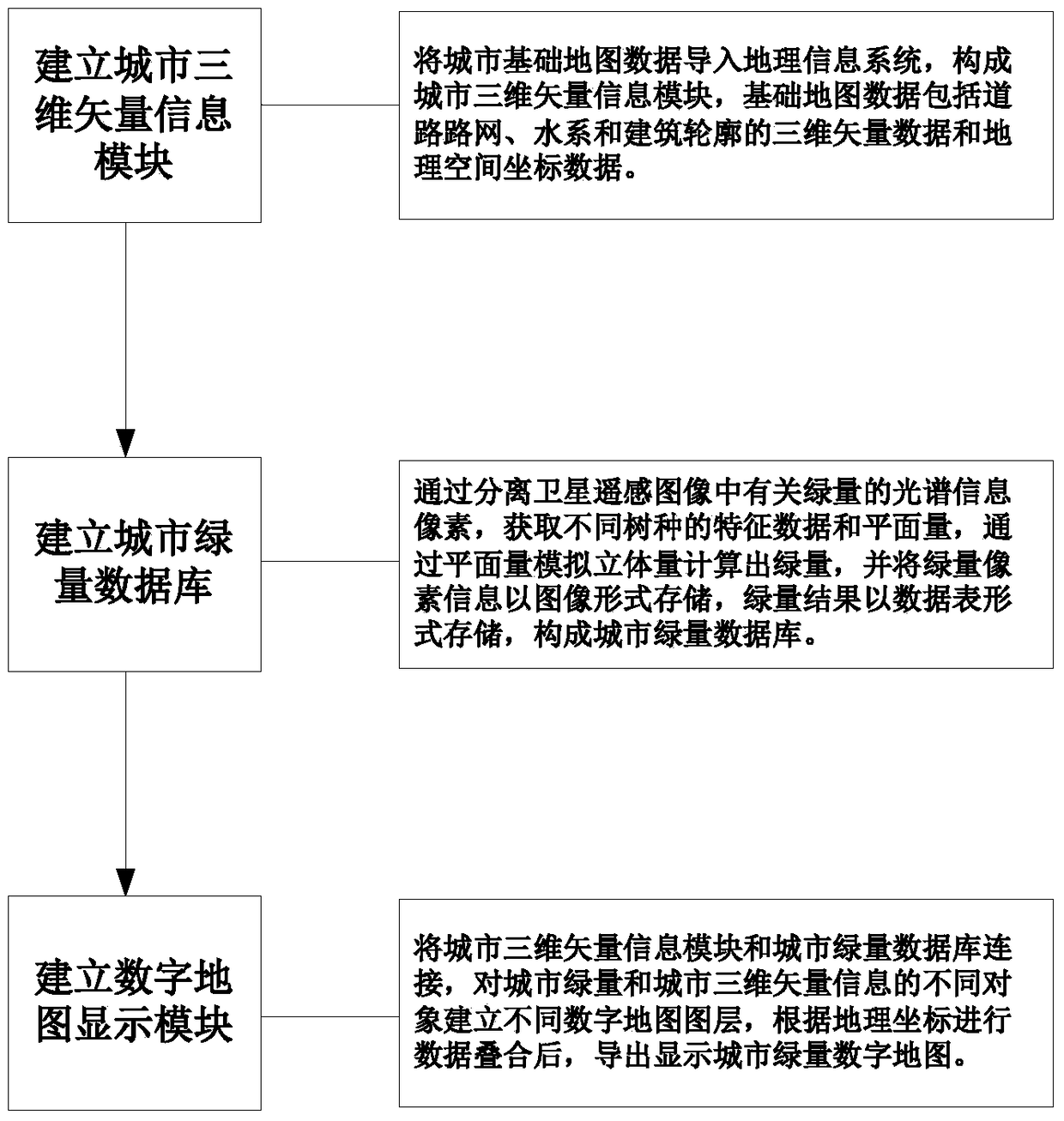
[0046] like figure 1 As shown, a method for making and displaying a digital map of urban green quantity disclosed in an embodiment of the present invention mainly includes the following steps:

[0047] 1) Establish a three-dimensional vector information module for the city.

[0048] The basic map data of the city is imported into the geographic information system to form a three-dimensional vector information module of the city. The basic map data here includes three-dimensional ...


PUM


Abstract

The invention discloses a method for making and displaying a digital map of urban green quantity. The characteristic data and plane quantity of different tree species are used to calculate the green quantity by simulating the three-dimensional quantity through the plane quantity, and the green quantity pixel information is stored in the form of an image, and the green quantity result is stored in the form of a data table to form an urban green quantity database; the urban three-dimensional vector The information module is connected with the urban green quantity database, and different attribute layers are established, and the database information is superimposed, and the digital map of urban green quantity is exported and displayed. The invention realizes the visual dynamic query display of the green quantity data by superimposing the green quantity data and the city map under a digital map system. The invention can be oriented to the fields of urban planning, landscape gardening and architectural design, and can be used as a practical method for auxiliary design and decision-making management of urban construction.

Description

technical field [0001] The invention relates to a method for making a digital map, and more particularly to a method for making and displaying a digital map of urban green quantity. Background technique [0002] In the period of rapid urban development, improving the quality of urban environment is an important task of urban space environment planning and urban greening garden construction, which requires scientific and reasonable planning of urban green space system. For cities, especially urban centers with extremely high building density, using limited land resources and choosing a good greening structure can effectively improve the ecological and environmental benefits of urban greening. Green quantity is the total amount of green plants per unit area, also known as three-dimensional green biomass. It is a vegetation index that reflects the growth state and spatial distribution density of vegetation. The size of green quantity affects the economic and ecological benefits...

Claims


Application Information

Patent Timeline
Patent Type & Authority Patents(China)
IPC IPC(8): G06F16/56G06K9/00
CPCG06F16/29G06F16/56G06V20/176G06V20/182G06V20/188G06V20/13
Inventor 杨俊宴陆小波
Owner SOUTHEAST UNIV
Learn More