CORS-based sub-meter integrated positioning navigation system and navigation method

A combined positioning and navigation system technology, applied in the field of satellite positioning and navigation applications, can solve problems such as low precision, satellite signals are easily interfered, and satellite signals are unstable, and achieve the effect of improving positioning accuracy and continuously stabilizing position information

Inactive Publication Date: 2016-11-09
NANJING LES INFORMATION TECH
View PDF3 Cites 7 Cited by
  • Summary
  • Abstract
  • Description
  • Claims
  • Application Information

AI Technical Summary

Problems solved by technology

Generally, the accuracy of traditional satellite positioning is 5-20m, which is low in accuracy and cannot meet the monitoring needs of actual road vehicles. Because satellite signals are easily interfered, the real-time positioning stability is poor. For urban road greening, various buildings with different heights etc. GPS and Beidou satellite signals are unstable, and it is difficult to meet actual needs by relying solely on satellite positioning and navigation. The traditional positioning and navigation system only combines INS technology. Although it can provide continuous and stable position information, it cannot improve the accuracy of position information.
[0003] At present, the positioning accuracy of the traditional satellite positioning and navigation system is 5-20m, which is low and cannot meet the requirements of high-precision sub-meter positioning and navigation. However, some existing high-precision systems have not been combined with INS technology. Unable to provide continuous and stable location information in the application environment

Method used


Image

  • CORS-based sub-meter integrated positioning navigation system and navigation method
  • CORS-based sub-meter integrated positioning navigation system and navigation method
  • CORS-based sub-meter integrated positioning navigation system and navigation method

Examples


Embodiment Construction

[0020] The technical term included in the present invention has:

[0021] CORS: (Continuously Operating Reference Stations) Continuously operating reference stations

[0022] GNSS: (Global Navigation Satellite System) global satellite navigation system

[0023] GPRS: (General Packet Radio Service) general packet radio service technology

[0024] RTD: (Real Time Differential) real-time dynamic code phase difference technology

[0025] INS: (Inertial Navigation System) inertial navigation system.

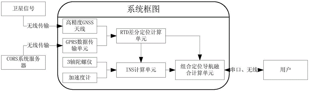
[0026] The principle block diagram of the technical scheme of the present invention is as follows: figure 1 As shown, the system includes: RTD differential positioning calculation unit, inertial navigation calculation unit, integrated positioning and navigation fusion calculation unit, GPRS data transmission unit, high-precision GNSS antenna, 3-axis gyroscope and accelerometer, etc.

[0027] The RTD differential positioning calculation unit mainly obtains the correction data of th...


PUM


Abstract

The invention discloses a CORS-based sub-meter integrated positioning navigation system and a corresponding navigation method. By acquiring the correction number of a CORS base station server and based on an RTD algorithm, the positioning accuracy of satellites is improved, and a high-accuracy sub-meter positioning result can be output. Moreover, as an INS technology is not dependent on the signal strength and is undisturbed, continuous high-accuracy and high-stability position information can be provided for users.

Description

technical field [0001] The invention relates to the application field of satellite positioning and navigation. Background technique [0002] With the continuous development and improvement of satellite navigation and positioning systems such as GPS and Beidou, the application of satellite navigation and positioning has also emerged at the historic moment and has continued to grow and develop. , emergency vehicle position reports, etc., the requirements for position accuracy are getting higher and higher, and it is necessary to be able to realize lane-level positioning and navigation, which means that the positioning and navigation system must be able to provide sub-meter level positioning accuracy. Generally, the accuracy of traditional satellite positioning is 5-20m, which is low in accuracy and cannot meet the monitoring needs of actual road vehicles, and because satellite signals are easily interfered, the real-time positioning stability is poor. etc. GPS and Beidou sate...

Claims


Application Information

Patent Timeline
Patent Type & Authority Applications(China)
IPC IPC(8): G01S19/47G01C21/16
CPCG01C21/165G01S19/47
Inventor 成晟朱超羊有道严璐
Owner NANJING LES INFORMATION TECH
Why Eureka
Try Eureka