Multi-source heterogeneous spatial data flow method based on Oracle database

A spatial data, multi-source heterogeneous technology, applied in the database field, can solve the problems of difficult data sharing, difficult data interoperability, and not much, etc., to achieve the effect of improving efficiency

Active Publication Date: 2017-05-24
CHINESE ACAD OF SURVEYING & MAPPING
View PDF2 Cites 30 Cited by
  • Summary
  • Abstract
  • Description
  • Claims
  • Application Information

AI Technical Summary

Problems solved by technology

Although many solutions have been proposed for spatial data management based on non-relational databases, they are not widely used in commercial applications. The reasons include: the technology of distributed vector data storage, spatial operation and distributed processing is not perfect, Further exploration and research are needed; there is still insufficient support for multi-source heterogeneous data; there is no good solution for how to integrate spatial data in existing relational databases
[0007]

Method used


Image

  • Multi-source heterogeneous spatial data flow method based on Oracle database
  • Multi-source heterogeneous spatial data flow method based on Oracle database
  • Multi-source heterogeneous spatial data flow method based on Oracle database

Examples


Embodiment example

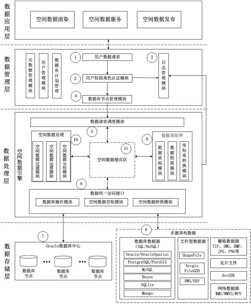
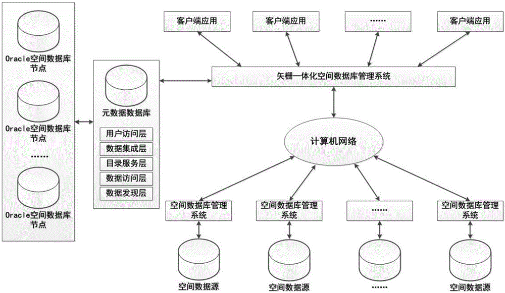
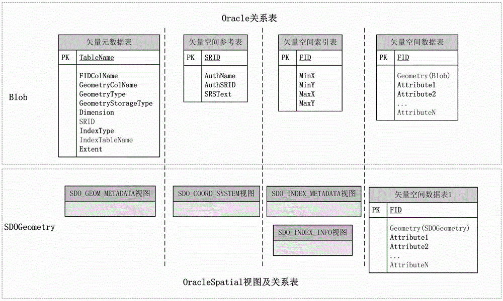
[0130]Based on the NewMap software spatial database engine API, the applicant developed the Oracle data-driven engine (hereinafter referred to as NewMap SDE, referred to as NMSDE) based on the above-mentioned technology. The geometric information of spatial data is stored by SDO_GEOMETRY object, which is different from ArcSDE (spatial data geometric information uses ST_GEOMETRY object. Storage) on the same computer (CPU 8-core 3.6GHz, 4G memory, 100M Ethernet card), the same network bandwidth (100M Ethernet), the same Oracle database server (CPU 8-core 2.40GHz, 16G memory, 100M Ethernet card) ) to perform storage and query efficiency tests.

[0131] The test data adopts the vector data provided by OpenStreetMap (OSM) in March 2016, Japan in Asia, and the format is Shapefile. The data size is 3.29GB, and there are 8 layers in total, including 2 point layers and 3 line and area layers each. The raster data uses TIFF format image data TIFF01 (0.874GB) with 3 bands of 18915×15772,...


PUM


Abstract

The invention discloses a multi-source heterogeneous spatial data flow method based on an Oracle database. The method comprises the steps of receiving a data request; determining a database node to be accessed through a spatial data index according to the request; reading multi-source heterogeneous data, and conducting spatial data model transformation according to a spatial data conversion module; conducting simple pretreatment on the conversed data; storing the data or storing the data after processing the data. According to the multi-source heterogeneous spatial data flow method based on the Oracle database, mature relational database spatial data storage and spatial database engine technologies are combined, and by building an integrative vector and raster data storage model, optimizing a spatial data retrieval mechanism and integrating spatial data which is distributed and stored in each spatial database, and the data flow of the heterogeneous spatial data is achieved. An Oracle database data driving engine NMSDE is developed based on the multi-source heterogeneous spatial data flow method, and the tests show that both the storage efficiency and inquiring efficiency of the Oracle database data driving engine NMSDE are superior to ArcSDE.

Description

technical field [0001] The invention relates to the technical field of databases, in particular to a multi-source heterogeneous spatial data flow method based on an Oracle database. Background technique [0002] With the continuous development of spatial geographic information technology, the means of obtaining geographic spatial information have been continuously enriched. Geospatial data presents the characteristics of diverse data sources, differentiated data models, decentralized data storage, complex spatial relationships, and massive quantities. For this reason, various spatial database technologies, spatial data engine technologies, and distributed storage management technologies oriented to data and applications have emerged, which effectively solve the problem of geospatial data storage and management to a certain extent or from a certain aspect. question. [0003] For the storage, organization, management and release of multi-source heterogeneous spatial data, the...

Claims


Application Information

Patent Timeline
IPC IPC(8): G06F17/30
CPCG06F16/214G06F16/2237G06F16/2246G06F16/2282G06F16/27G06F16/284
Inventor 李成名吴政沈建明孙伟洪志远武鹏达方驰宇刘丽
Owner CHINESE ACAD OF SURVEYING & MAPPING
Why Eureka
Try Eureka