A dynamic model/airborne sensor integrated navigation method for quadrotor aircraft

A technology of quadrotor aircraft and dynamic model, which is applied in the field of integrated navigation, can solve the problems of decreased accuracy of navigation system, decreased performance, low accuracy and reliability of inertial sensors, etc., and achieves the effect of improving the reliability of navigation.

Active Publication Date: 2021-09-17
NANJING UNIV OF AERONAUTICS & ASTRONAUTICS
View PDF9 Cites 0 Cited by
  • Summary
  • Abstract
  • Description
  • Claims
  • Application Information

AI Technical Summary

Problems solved by technology

Limited by cost and volume, the inertial sensors used in quadrotor aircraft have low accuracy and reliability, and are susceptible to performance degradation or even failure due to external temperature and vibration interference.
At this time, the accuracy of the navigation system will decrease, which will affect flight safety.
At present, there is no navigation method for quadrotor aircraft in the case of inertial sensor failure

Method used


Image

  • A dynamic model/airborne sensor integrated navigation method for quadrotor aircraft
  • A dynamic model/airborne sensor integrated navigation method for quadrotor aircraft
  • A dynamic model/airborne sensor integrated navigation method for quadrotor aircraft

Examples


Embodiment Construction

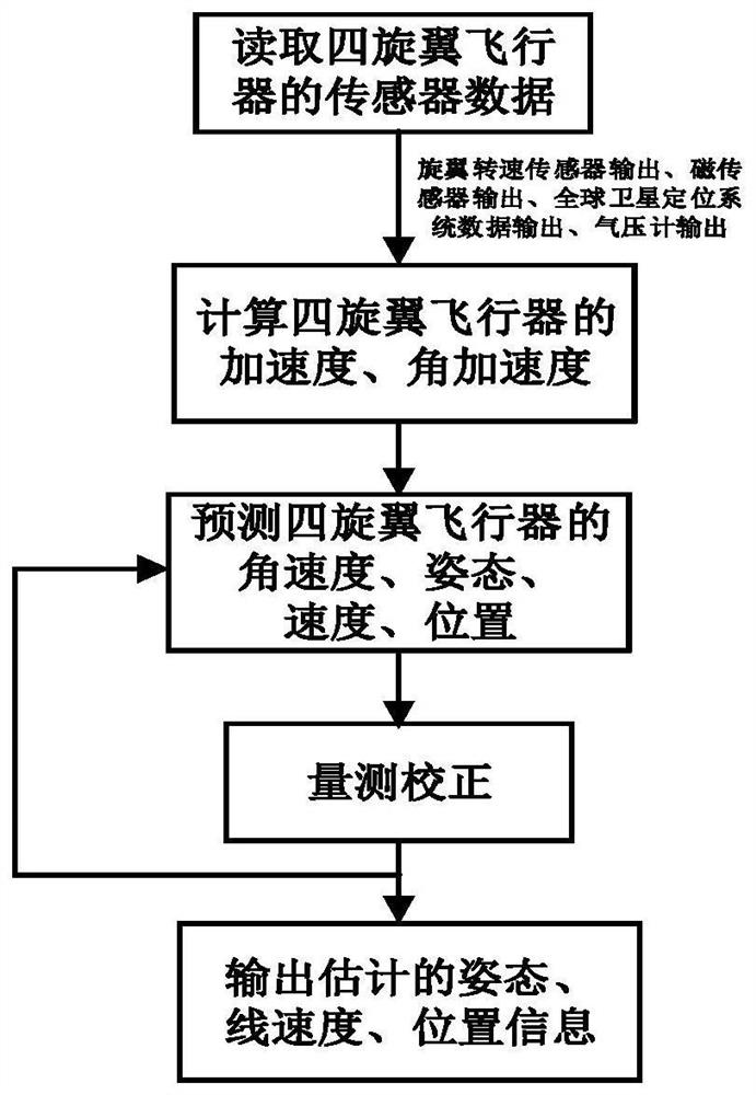
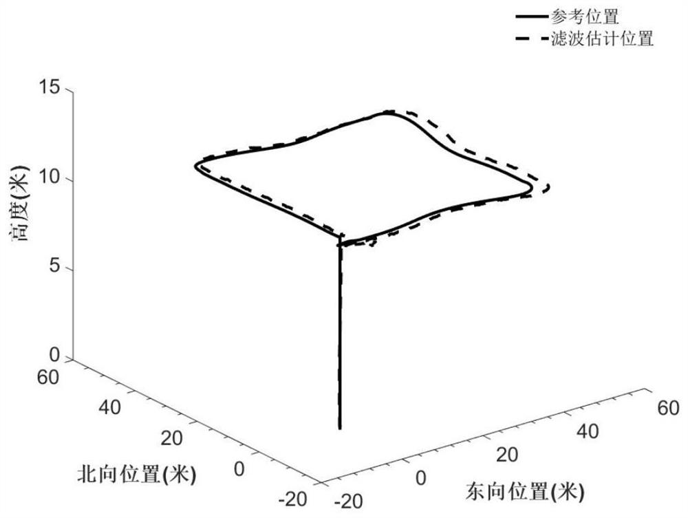
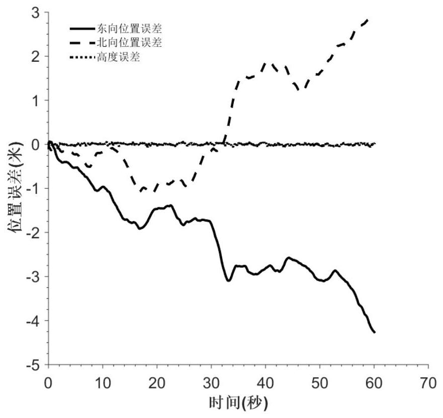
[0060] The process of the method of the present invention is like figure 1 As shown, the specific steps are as follows:

[0061] Step 1: The cycle reads the K time four-rotor aircraft load cell, including rotor speed sensor information Ω 1 (k), Ω 2 (k), Ω 3 (k), Ω 4 (k), which is the speed of four rotors; GPS information V NG (k), V EG (k), V DG (k), which is the north to speed, east-to-race, and speed, P NG (k), P EG (k), it is the north direction, east position; H b (k) is the air pressure height meter information; ψ m (k) is a magnetic sensor information;

[0062] Step 2: Calculate the acceleration and angular acceleration of the K-time four-rotor aircraft;

[0063] The acceleration information is calculated by the following formula:

[0064]

[0065]

[0066]

[0067] The angular acceleration information is calculated by the following formula:

[0068]

[0069]

[0070]

[0071] Step 3: Predict the angular velocity, gesture, speed, location of the K time four-rotor...


PUM


Abstract

The invention discloses a dynamic model / airborne sensor combined navigation method of a four-rotor aircraft, which belongs to the field of combined navigation. The present invention utilizes the dynamics model of quadrotor aircraft, combines with airborne sensor, estimates its angular velocity, attitude, speed, position information, and in the present invention, the dynamics model that adopts comprises lift force model, resistance model, torque model , rolling moment model, and pitching moment model. The airborne sensors used include rotor speed sensors, magnetic sensors, satellite navigation systems, and barometric altimeters. In this method, inertial sensors such as gyroscopes and accelerometers commonly used in current quadrotor aircraft are not used, and the dynamic model of the quadrotor aircraft outputs acceleration and angular acceleration information to replace the inertial sensors. This method can be used to solve the quadrotor navigation problem when the inertial sensor fails.

Description

Technical field [0001] The present invention belongs to the field of navigation, particularly relates to a four-kinetic model rotorcraft / sensor combination onboard navigation method. Background technique [0002] Four-rotor aircraft with a small, simple structure, hovering and vertical takeoff and landing, etc., especially suitable for surveillance, reconnaissance and other tasks in the near-surface environment (such as indoor, urban and jungle, etc.), and has broad prospects for military and civilian . Navigation system that provides navigation information necessary for flight control systems for the four-rotor aircraft, which is complete complex missions necessary guarantees. [0003] The commonly used four sensor includes an inertial sensor rotorcraft, the GNSS (satellite navigation system), a magnetic sensor, a barometric altimeter, wherein the inertial sensor comprises a gyroscope and an accelerometer. Cost, limited by the volume of the four selected rotorcraft inertial se...

Claims


Application Information

Patent Timeline
Patent Type & Authority Patents(China)
IPC IPC(8): G01C21/20
CPCG01C21/20
Inventor 吕品刘士超赖际舟许晓伟白师宇
Owner NANJING UNIV OF AERONAUTICS & ASTRONAUTICS
Why Eureka
Try Eureka