Dynamic ship route generating method based on sea chart data

A technology of nautical chart data and map data, which is applied in navigation, surveying and navigation, navigation calculation tools, etc., can solve the problems of limited operating personnel's professional level, route experience, and low efficiency of route quality, and improve route efficiency and economy. sexual effect

Active Publication Date: 2019-09-10
THE 28TH RES INST OF CHINA ELECTRONICS TECH GROUP CORP
View PDF4 Cites 16 Cited by
  • Summary
  • Abstract
  • Description
  • Claims
  • Application Information

AI Technical Summary

Problems solved by technology

This manual method is inefficient, and the quality of the designed rout

Method used


Image

  • Dynamic ship route generating method based on sea chart data
  • Dynamic ship route generating method based on sea chart data
  • Dynamic ship route generating method based on sea chart data

Examples


Embodiment Construction

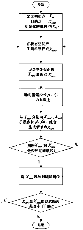
[0045] A method for generating dynamic routes based on chart data is described below with an example, see figure 1 ;

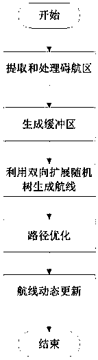
[0046] In the present invention, 1. A method for generating a dynamic route based on chart data, including the processing of navigable area data in the map: extracting and processing the navigable area from the map data:

[0047] Through the map data access interface, the attribute information of each area can be obtained; the navigation obstruction area can be divided into point and surface obstruction area according to its shape;

[0048] 1.1. Handling of point obstructions:

[0049] The navigable areas formed by submerged reefs, shipwrecks, and submerged reefs in the map are treated as point-shaped navigable areas. When the distance between points is greater than 500 meters, the actual situation can be adjusted according to the safety distance and directly used as a separate point. For the point set whose distance is less than 500 meters, the minimum con...


PUM


Abstract

The invention discloses a dynamic ship route generating method based on sea chart data. The dynamic ship route generating method based on the sea chart data comprises the following steps of: extracting and processing a ship obstacle zone; generating a buffer zone; generating a ship route using a two-way extended random tree; performing path optimization; and performing dynamic update on the ship route. The dynamic ship route generating method based on the sea chart data can automatically calculate a better safety ship route according to the starting point and end point input by the user or obtained from the sea chart, can provide warnings and prompts when the navigation deviates from the planned route, and dynamically update the ship route according to the change of the position and environment of the ship, so as to guarantee the safety of personnel and ships, and improve the efficiency and economy of the ship route. In addition, the effect of the dynamic ship route generating method based on the sea chart data is verified in the development of the XX marine police system.

Description

technical field [0001] The invention belongs to the field of ship route design, and in particular relates to a method for automatically updating ship route design dynamically and in real time based on extracted navigable area data of charts. Background technique [0002] The safety of ship navigation has always been the main concern of maritime navigation personnel, especially when performing special operations such as refuge at sea, rescue, law enforcement and rights protection, etc., there is a higher demand for the accuracy and real-time performance of route design. The existing ship route design basically relies on manual analysis of paper charts and personal experience and knowledge to complete the drafting of the planned route before performing the task. This manual method is inefficient, and the quality of the designed routes is limited by the professional level and experience of the operators. [0003] When ships are sailing at sea, an efficient, fast and accurate m...

Claims


Application Information

Patent Timeline
IPC IPC(8): G01C21/20
CPCG01C21/203
Inventor 丁振平张遥李勇
Owner THE 28TH RES INST OF CHINA ELECTRONICS TECH GROUP CORP
Why Eureka
Try Eureka