Robust segmentation method for determining deciduous forest tree-level parameters by adopting airborne laser radar

An airborne laser radar and parameter measurement technology, which is applied in the field of forest resources monitoring, can solve the problems of missing segmentation, wrong segmentation, and lack of trunk information in the segmentation results, and achieve the effect of improving data and improving the overall accuracy of segmentation

Pending Publication Date: 2020-07-17
HUNAN INST OF TECH
View PDF0 Cites 8 Cited by
  • Summary
  • Abstract
  • Description
  • Claims
  • Application Information

AI Technical Summary

Problems solved by technology

In conclusion, these errors are mainly caused by the top-down segmentation strategy. Although this tree segmentation method is robust to the crown segmentation and does not need to know the shape and ...

Method used


Image

  • Robust segmentation method for determining deciduous forest tree-level parameters by adopting airborne laser radar
  • Robust segmentation method for determining deciduous forest tree-level parameters by adopting airborne laser radar
  • Robust segmentation method for determining deciduous forest tree-level parameters by adopting airborne laser radar

Examples


Embodiment Construction

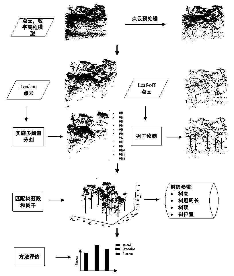
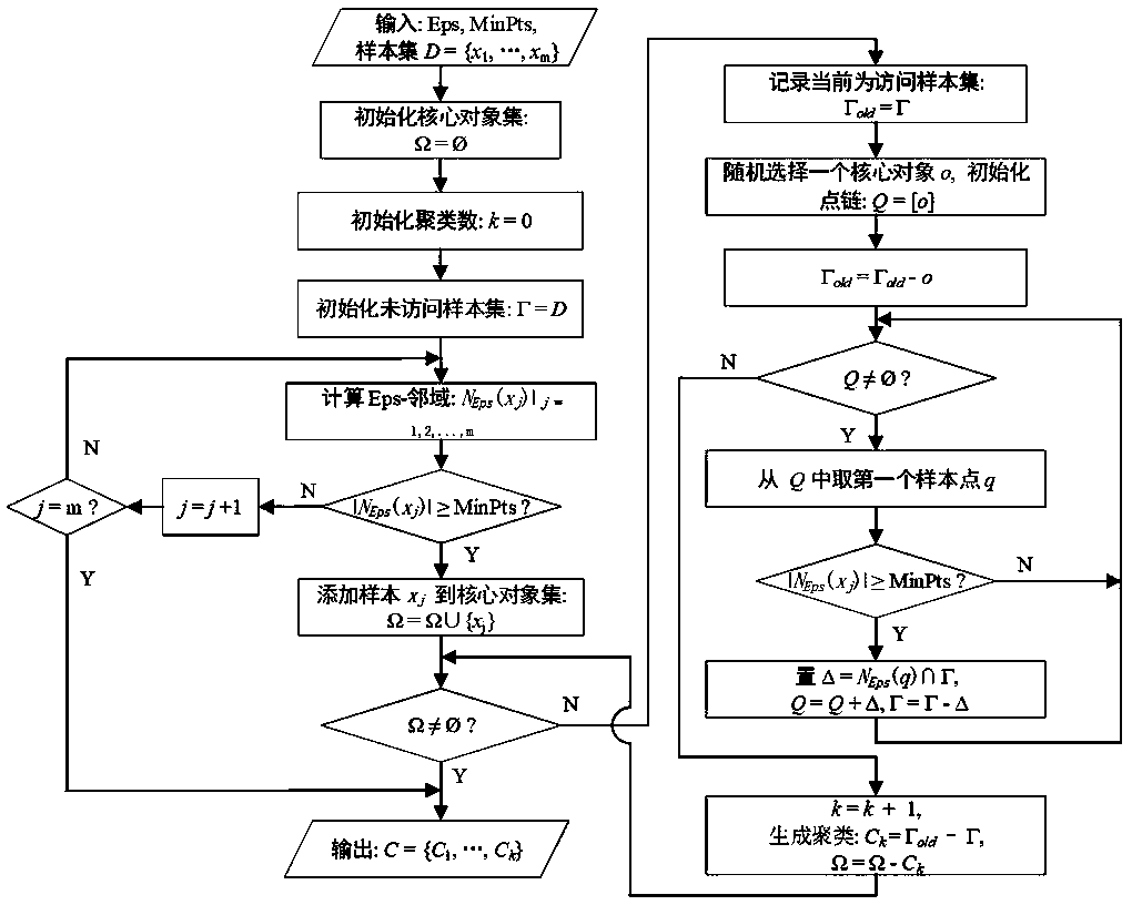
[0063] In order to facilitate the understanding of those skilled in the art, the present invention will be further described below in conjunction with the embodiments and accompanying drawings, and the contents mentioned in the embodiments are not intended to limit the present invention.

[0064] The implementation location of this embodiment is Robinson Forest (RF, coordinates: 37°28′23″N 83°08′36″W) at the University of Kentucky, located in Brissett, Perry, and Knott counties in southeastern Kentucky. The rugged eastern section of the Berland Plateau. The area is a diverse, contiguous mixed mesophyte forest with approximately 80 tree species, including northern red oak (Quercus rubra L.), white oak (Quercus alba L.), boxwood (Liriodendron tulipifera L.), American beech (Fagus grandifolia Ehrh.), eastern hemlock (Tsuga canadensis (L.) Carrière) and sugar maple (Acersaccharum Marsh.) and other dominant and secondary dominant trees. Understory plants include Cercis canadensis ...


PUM


Abstract

The invention discloses a robust segmentation method for determining deciduous forest tree-level parameters by adopting an airborne laser radar. The invention relates to the technical field of forestresource monitoring. The method comprises the following steps: 1, ; carrying out low-altitude flight laser radar scanning and hollow flight laser radar scanning on the deciduous forest area and respectively acquiring Leaf-on data and Leaf-off data; preprocessing and analyzing the Leaf-on data, and then obtaining crown parameters by adopting a multi-threshold segmentation method; carrying out the preprocessing and analysis of the Leaf-off data, and separating all trunk radar points; the method comprises the following steps: obtaining trunk radar points of a deciduous forest, clustering the obtained trunk radar points to obtain trunk parameters, matching the crown parameters with the trunk parameters to obtain single trees, segmenting and describing the single trees, and extracting tree-level structure parameters from the single trees to complete the determination of the tree-level parameters of the deciduous forest. According to the method, multi-threshold segmentation and a trunk detection method are combined, so that the accuracy of tree-level parameter extraction can be improved.

Description

technical field [0001] The invention relates to the technical field of forest resource monitoring, in particular to a robust segmentation method for measuring tree-level parameters of deciduous forests by using an airborne laser radar. Background technique [0002] Forest resource inventory is of great significance to the protection of the ecological environment and the well-being of humans and wild animals. Traditionally, forest surveys are labor-intensive, time-consuming, and limited by spatial accessibility, since in field surveys, most tree-level information and parameters are estimated by manually measuring plots. Remote sensing-based inventory systems have been vigorously developed over the past few decades. Among the current remote sensing technologies, airborne light detection and ranging (LiDAR) technology has outstanding features. [0003] The method of obtaining three-dimensional (3D) vegetation structure by airborne lidar has superior ability, specifically, aft...

Claims


Application Information

Patent Timeline
IPC IPC(8): G06K9/62G06T5/00G06T7/11G06T7/136
CPCG06T7/11G06T7/136G06T5/002G06F18/23G06F18/22
Inventor 王小虎黄银珍罗泽严亚周黄海波洪俊
Owner HUNAN INST OF TECH
Why Eureka
Try Eureka