Method for managing remedied earthwork volume of polluted site by combining aerial survey of unmanned aerial vehicle and BIM technology

A site restoration and unmanned aerial vehicle technology, applied in the field of soil restoration, can solve problems such as complex model establishment and difficult earthwork measurement and calculation, and achieve the effects of improving measurement accuracy, reducing project disputes, increasing timeliness and authenticity

Pending Publication Date: 2021-07-13
广东省建筑工程监理有限公司
View PDF6 Cites 8 Cited by
  • Summary
  • Abstract
  • Description
  • Claims
  • Application Information

AI Technical Summary

Problems solved by technology

[0005] The purpose of the present invention is to solve the problems in the field of contaminated site restoration in the above-mentioned background technology, and combine the drone aerial photography technology and BIM modeling technology in

Method used


Image

  • Method for managing remedied earthwork volume of polluted site by combining aerial survey of unmanned aerial vehicle and BIM technology

Examples


Embodiment Construction

[0028] The following specific examples will further describe the present invention in detail. The specific embodiments described here are only used to explain the present invention, not to limit the present invention.

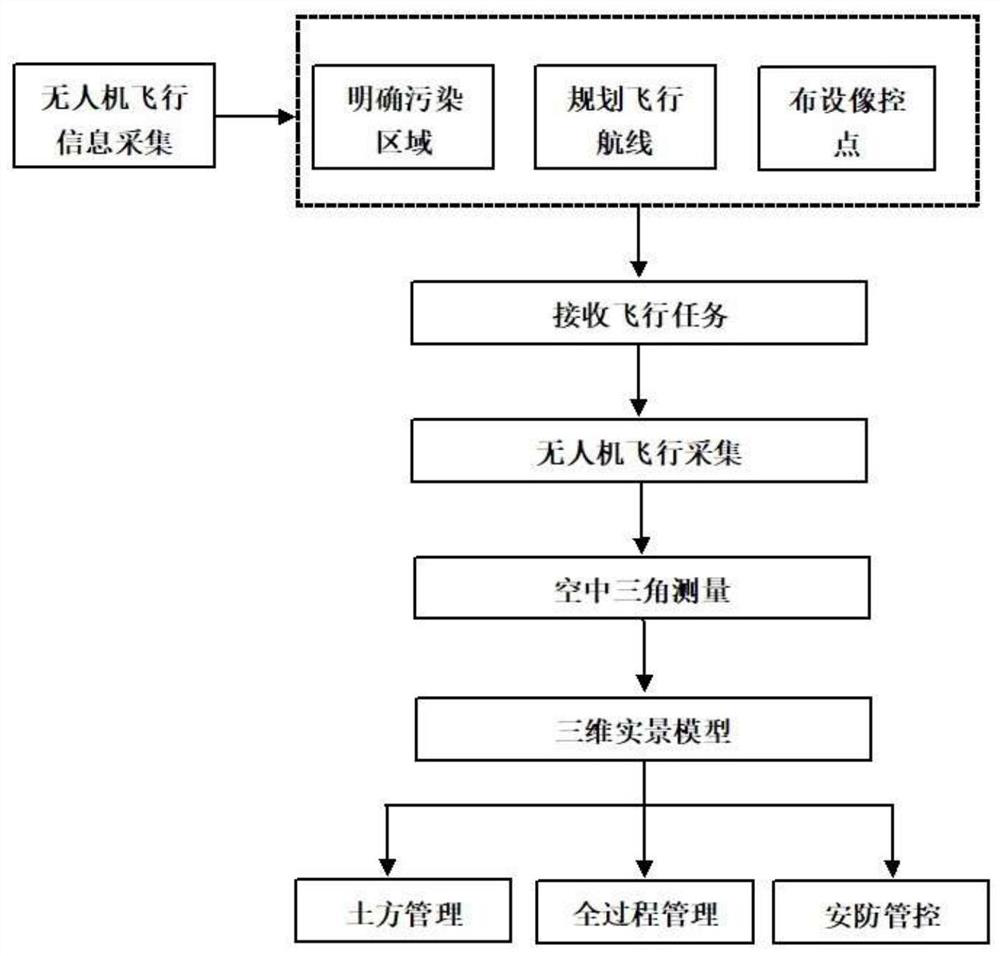
[0029] A method for managing earthwork volumes for remediation of polluted sites in combination with UAV aerial survey and BIM technology, the specific steps are as follows:

[0030] Step 1: Data collection of UAV data on polluted sites

[0031]The DJI PHANTOM 4RTK UAV aerial survey system is adopted, which has a centimeter-level navigation and positioning system and a high-performance imaging system. Firstly, according to the historical location of the factory buildings, warehouses and equipment of the chemical enterprise and the actual situation of the polluted site, the area and boundary of the polluted site are preliminarily estimated, and the flight area is planned through the DJI GS RTK route planning software, and 10 aerial survey routes are designed wi...


PUM


Abstract

The invention provides a method for managing remedied earthwork volume of a polluted site by combining aerial survey of an unmanned aerial vehicle and BIM technology comprising the following steps: using an unmanned aerial vehicle to carry out data information acquisition on a polluted site, exporting unmanned aerial vehicle data, and in three-dimensional modeling data processing software, outputting point and line data with elevation properties, based on the soil color, the vegetation coverage condition and the position of the waste residue and waste material pile, obtaining an approximate region boundary of the polluted site; collecting soil samples on points near the boundary line to acquire a boundary of an accurate polluted site area importing the data into revit software to generate a three-dimensional original terrain model, and establishing a BIM model; and based on the BIM model, obtaining information data such as excavation work amount, excavation boundary, depth and the like of earthwork, and realizing full-process management and control of a polluted site remediation project. The unmanned aerial vehicle is used for obtaining the panorama of the whole polluted site and generating the three-dimensional live-action model, and the three-dimensional live-action model is combined with the BIM model, so that the manual measurement modeling cost is greatly reduced, the timeliness and authenticity of the polluted site repair construction process are improved, and the requirement of three-dimensional visualization progress comparison is met.

Description

technical field [0001] The invention relates to the field of soil remediation, in particular to a method for managing the amount of earthwork for remediation of polluted sites by combining aerial surveying with UAV and BIM technology. Background technique [0002] In recent years, the scale of large and medium-sized cities across the country has continued to expand, and urban construction land is insufficient. Therefore, the government has relocated some chemical companies from the suburbs to the outer suburbs, and then converted industrial land into construction land. However, the long-term production of chemical companies has caused soil pollution in the factory area. Before relocating the factory area to build residences and business districts, the contaminated soil needs to be restored and backfilled. According to the "Soil Environmental Quality-Soil Pollution Risk Control Standards for Construction Land (Trial)" (GB36600-2018), the construction land includes the first t...

Claims


Application Information

Patent Timeline
IPC IPC(8): G06Q10/04G06T17/10
CPCG06Q10/04G06T17/10
Inventor 朱志华黄隆盛杨求林
Owner 广东省建筑工程监理有限公司
Why Eureka
Try Eureka