Method and System For Aviation Navigation

a technology for aviation navigation and methods, applied in the field of computer-aided aircraft navigation methods and systems, can solve the problems of affecting aircraft of any size, fuel system malfunction, and small aircraft that are relatively prone to engine failure, and achieve the effect of reducing flight time or fuel consumption

Inactive Publication Date: 2007-06-21
INTELLECTUAL VENTURES I LLC
View PDF9 Cites 93 Cited by
  • Summary
  • Abstract
  • Description
  • Claims
  • Application Information

AI Technical Summary

Benefits of technology

[0009] The present invention provides a method and system whereby pilots may take greater account of emergency landing areas in the navigation of aircraft, including both in pre-flight planning and in-flight modifications. A system according to the invention may operate to navigate aircraft along a flight path that minimizes flight time or fuel consumption, while keeping the aircraft within a safe gliding distance of at least one emergency landing area at all times during the flight, or during some specified percentage of flight time. The system may, in the alternative or in addition, keep the aircraft within a defined distance of other locations along the route, or plan a route to maintain the plane within a glide distance of emergency landing areas, and prohibited, restricted, or otherwise limited airspace.

Problems solved by technology

At the same time, small aircraft are relatively prone to engine failures that require emergency landing under no power.
In addition, fuel system malfunctions or leaks, and fuel mismanagement or miscalculations, can impact aircraft of any size.
Under emergency or non-emergency conditions, selection of the best acceptable emergency landing area is rarely trivial, and mistakes can be fatal.
The calculation of maximum glide distance is prone to error, and the availability and location of acceptable emergency landing areas is often unknown.
The identification of an acceptable landing area can be significantly complicated if the aircraft is in, or above, conditions that obscure or limit the pilot's ability to view the ground, if the aircraft is flying at night, or if the aircraft is over rough terrain.
Similarly, if the aircraft is over an area with numerous roads, some of which are acceptable for landing and others are not (for reasons such as power lines crossing the road, insufficient road width and obstacle clearance, etc), or in other conditions, the pilot may incorrectly identify a landing target only to determine, when he is too close to the ground to pick another target, that the intended landing target is not in fact safe.
Current navigation equipment does not adequately assist aircraft pilots in the selection of emergency areas, in the event of engine failure.
If the pilot picks the wrong glideslope, approach speed, or other aspects of the approach, the pilot may overshoot or undershoot the target.
While the likelihood of such a “miss” is increased in poor visibility or significant wind conditions, it is present even in clear weather as pilots rarely practice “power-off” landings all the way from a cruise altitude to the ground.
However, the information gathering and calculation required to perform this task are too burdensome to permit detailed consideration of emergency landing in flight planning.

Method used


Image

  • Method and System For Aviation Navigation
  • Method and System For Aviation Navigation
  • Method and System For Aviation Navigation

Examples


Embodiment Construction

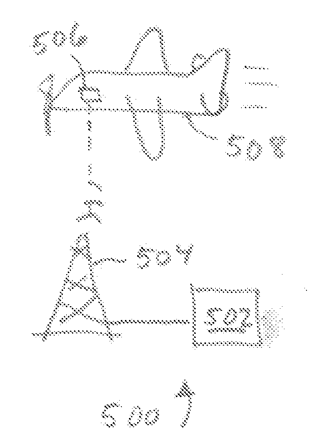
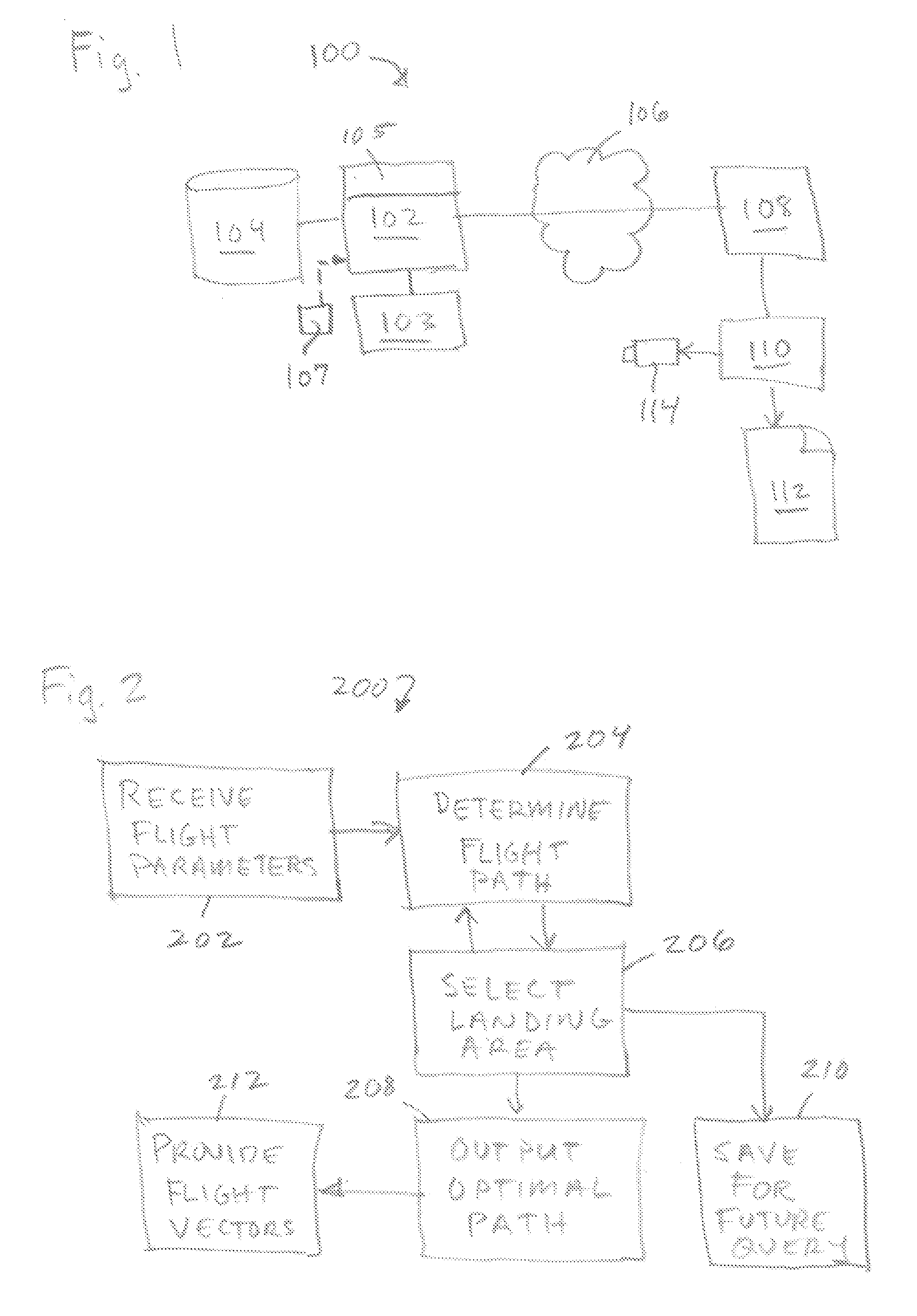
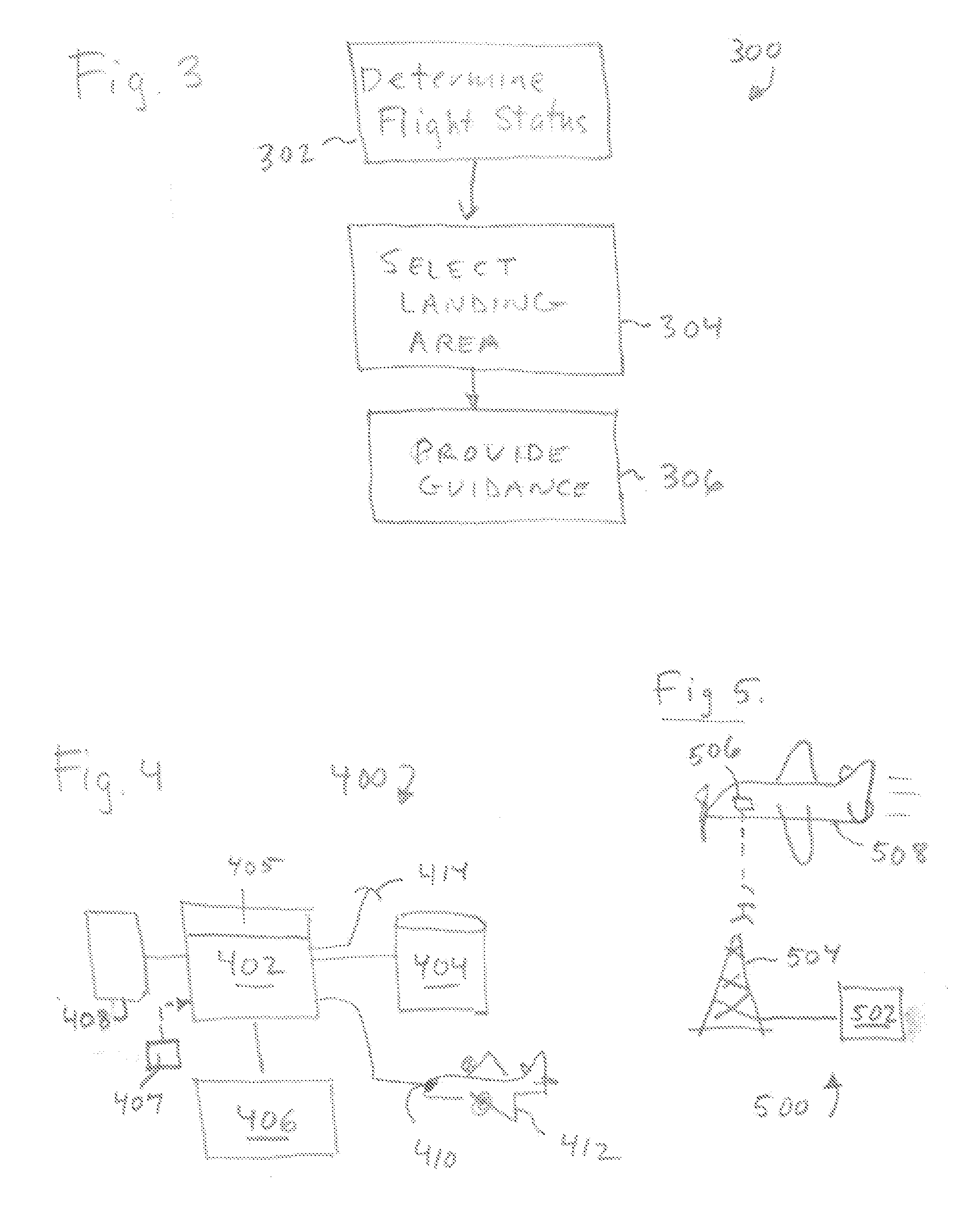
[0024] In the detailed description that follows, like element numerals are used to indicate like elements appearing in one or more of the figures. FIG. 1 is a schematic diagram showing aspects of an aircraft navigation system 100 according to an embodiment of the invention. It should be appreciated that the invention may be implemented on any suitable computing platform.

[0025] In an embodiment of the invention, navigation system 100 comprises a computer 102 operatively associated with a database 104. Database 104 may contain data describing the location and characteristics of emergency landing area. Data concerning landing areas may be gathered in advance using various manual or semi-automatic data. Such data may include the geographic location of the landing area, elevation, length and orientation of landing strips, surface type (i.e., pavement, gravel, grass, water), use type (airstrip, abandoned airstrip, roadway, field, lake, etc.), and any other information useful for selectin...


PUM


Abstract

A system operates to guide an aircraft to or along a route designed to maintain the aircraft within a safe glide distance of an acceptable emergency landing area. The system uses a database of emergency landing areas with glide characteristics of an aircraft to determine a route that minimizes travel time or other specified parameter, while keeping the aircraft within a safe glide distance of a landing area in the database meeting the landing requirements for the aircraft.

Description

CROSS-REFERENCE TO RELATED APPLICATION [0001] This application claims priority pursuant to 35 U.S.C. § 119(e) to U.S. provisional application Ser. No. 60 / 727,637, filed Oct. 17, 2006, which application is specifically incorporated herein, in its entirety, by reference.BACKGROUND OF THE INVENTION [0002] 1. Field of the Invention [0003] The present invention relates to computer-aided aircraft navigation methods and systems employing such methods. [0004] 2. Description of Related Art [0005] Currently, aircraft pilots, particularly pilots of small aircraft such as “VFR” aircraft, are permitted significant latitude in choice of flight path and altitude between the origin and destination of a given flight. At the same time, small aircraft are relatively prone to engine failures that require emergency landing under no power. In addition, fuel system malfunctions or leaks, and fuel mismanagement or miscalculations, can impact aircraft of any size. Under the proper weather and landing condit...

Claims


Application Information

Patent Timeline
Patent Type & Authority Applications(United States)
IPC IPC(8): G05D1/12
CPCG05D1/105G05D1/106
Inventor SHUSTER, GARY STEPHEN
Owner INTELLECTUAL VENTURES I LLC
Why Eureka
Try Eureka