Method for predicting the radio field level and/or the duration of propagation of cellular telephone networks using high-resolution terrain databases

a technology of high-resolution terrain databases and radio field levels, applied in network planning, electrical equipment, wireless communication, etc., can solve the problems of increasing the size of the cell, affecting the propagation speed of cellular telephone networks, and high cost of vector databases to produce and maintain. , to achieve the effect of accelerating the calculation

Active Publication Date: 2016-02-04
GOOGLE LLC
View PDF4 Cites 8 Cited by
  • Summary
  • Abstract
  • Description
  • Claims
  • Application Information

AI Technical Summary

Benefits of technology

[0013]As such, ray-launching in all of the horizontal directions with a small increment, i.e. a step that is sufficiently small and creating this learning, has for advantageous effect to further and very significantly accelerate the calculations.

Problems solved by technology

For example, an increase in the emitting power of a station would inevitably increase the size of the cell, provoking interference between neighboring cells.
Also, with regards to mobile terminals, the maximum power has to be limited by safety imperatives concerning the users and by the autonomy of their batteries.
Although this technique is effective, it has major disadvantages by the simple fact that it requires the availability of vector databases in order to perform the modeling of all of the contours of the buildings.
However, these vector databases are expensive to produce and maintain and are furthermore extremely cumbersome to manage and utilize, involving prohibitive calculation times when they are used for the processing of an application for predicting the radio field level and / or the duration of radio propagation in mobile telephone networks.

Method used


Image

  • Method for predicting the radio field level and/or the duration of propagation of cellular telephone networks using high-resolution terrain databases
  • Method for predicting the radio field level and/or the duration of propagation of cellular telephone networks using high-resolution terrain databases
  • Method for predicting the radio field level and/or the duration of propagation of cellular telephone networks using high-resolution terrain databases

Examples


first embodiment

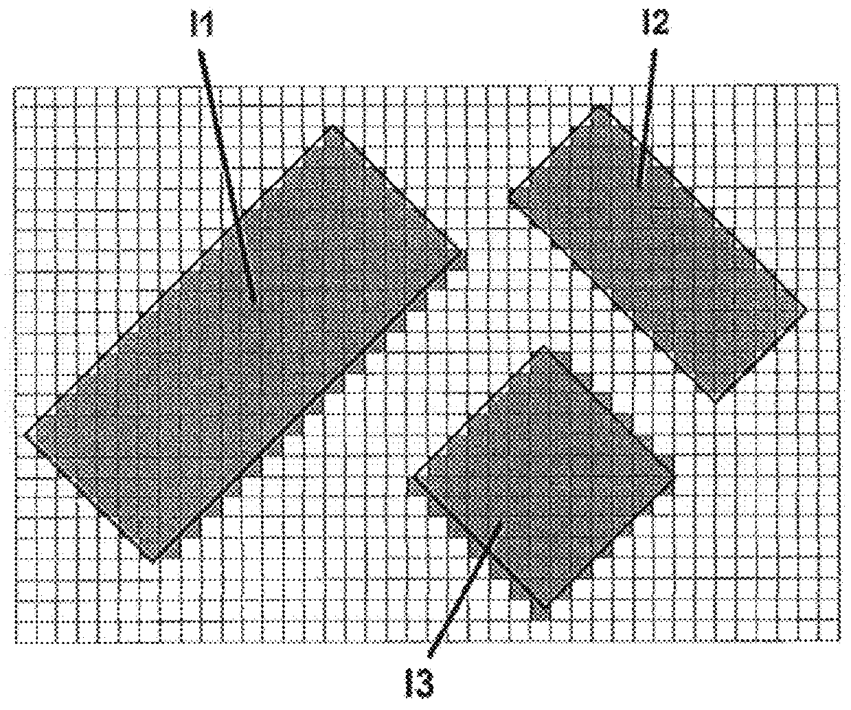
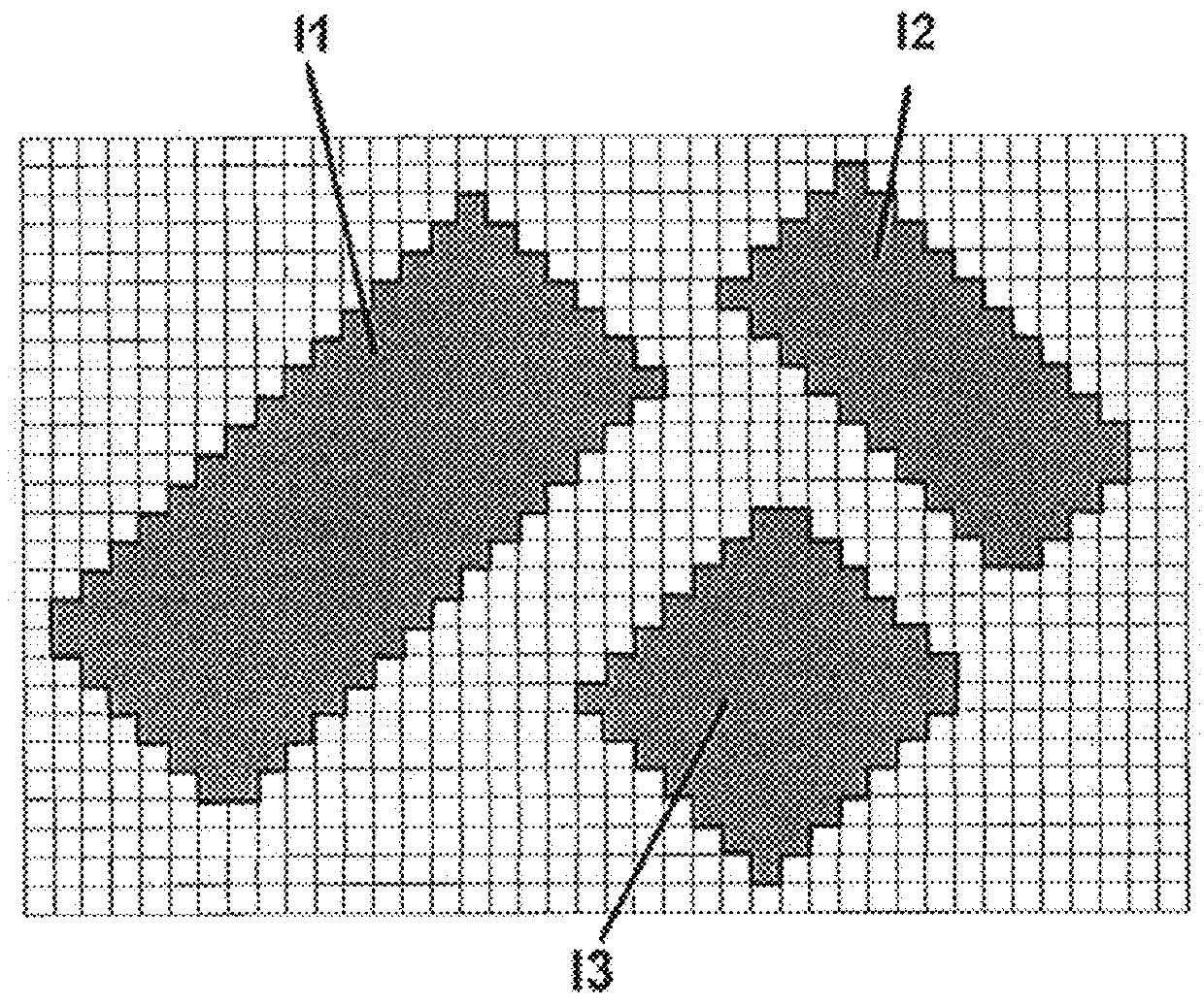
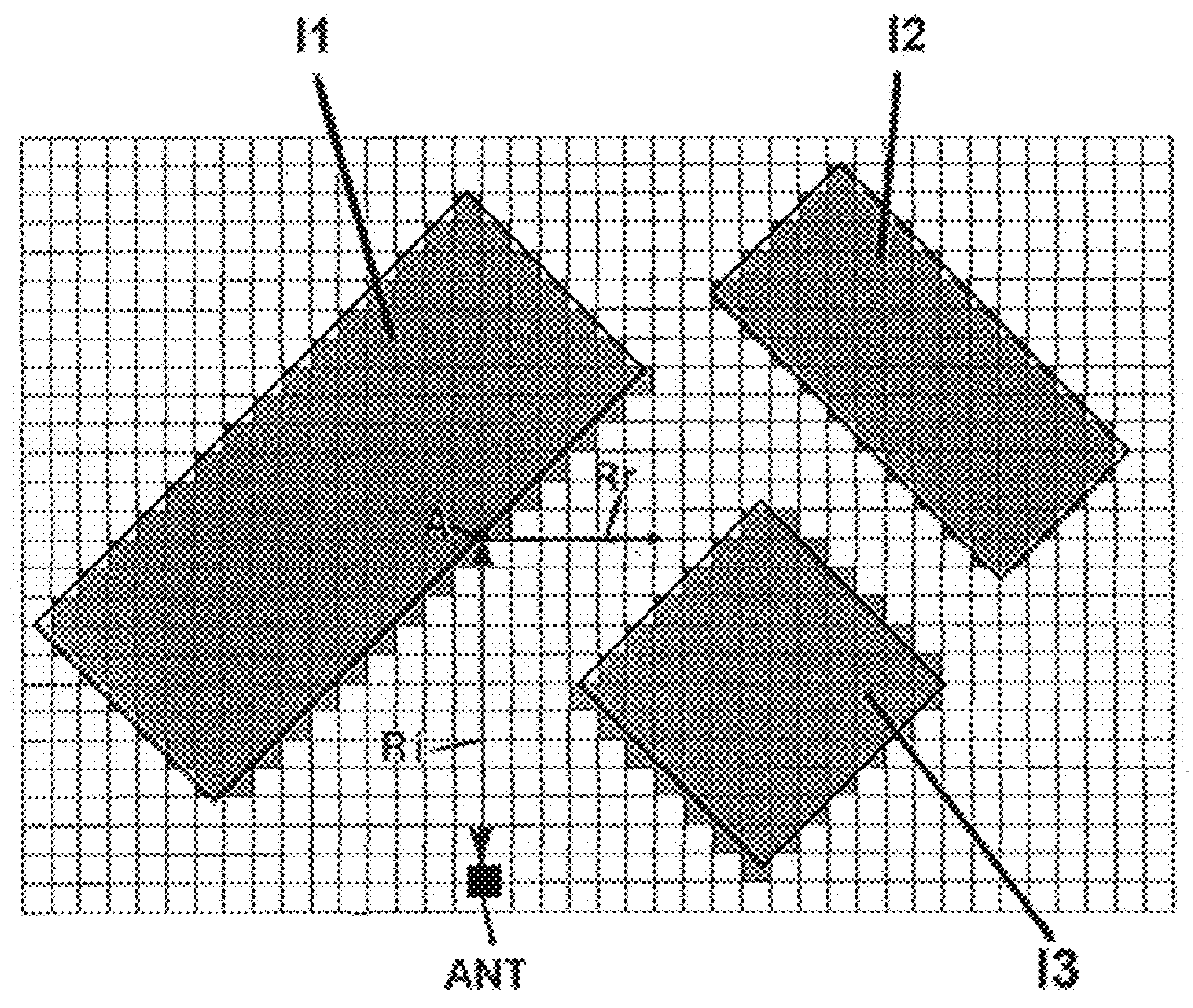
[0035]FIGS. 1a and 1b diagrammatically show an example of a step of the method with preprocessing according to the invention for which a simple configuration of obstacles in the urban environment is proposed, obstacles towards which the fictitious incident rays will be launched.

[0036]In this first embodiment, two steps are described to effectively implement the method for predicting the radio field level and / or the duration of radio propagation. A first step consists of a specific and single vectorization preprocessing of the contours of obstacles applied to the raster bases to linearize the contours of obstacles encountered by taking into account only the objects that represent the obstacles and as such retrieve said actual contours of obstacles. This preprocessing is carried out in a unique manner different from conventional methods, since the type of result is known, for example it is obvious that buildings practically all have vertical façades. In this way, knowing the method of...

second embodiment

[0056]Consequently, all of the steps of the second embodiment remain practically identical, with the only modification being the useful saving to memory of the results of the calculations proper to the immediate environment of an already analyzed point of impact and therefore of the information relating to the types of obstacles and the angles formed by said obstacles encountered. The raster database is thus linearized from one to the next.

[0057]In this way, thanks to this alternative it is permitted to save in the form of data grid the vector data calculated in the immediate environment of the point of impact, i.e. around said point of impact, so that the latter, once saved, can subsequently be used again when another launched ray encounters the immediate environment of the already analyzed point of impact. As such, the initial base of objects containing vector information is advantageously enriched as the execution unfolds of the ray-launching calculations, which has for main adva...


PUM


Abstract

A method of predicting the level of radio field and/or the duration of radio propagation of a mobile telephone network for the coverage of a cell using the ray tracing technique and utilizing geographical databases, wherein the database directly utilized is a matrix base composed of pixels, each pixel carrying at least an information item specific to the type of ground cover and an information item specific to the height of the ground cover, a vectorization processing is applied to the matrix base to linearize the contours of obstacles encountered while rays are fictitiously traced, the rays according to the obstacles encountered being either reflected or diffracted and scattered, whilst the global attenuation and/or propagation duration is calculated, the vectorization processing of the contours of obstacles being applied to matrix bases to linearize the contours of obstacles encountered by forming straight lines whose positions and various angles are known accurately.

Description

TECHNICAL FIELD[0001]This invention advantageously applies to the phase of characterizing and establishing mobile telephone networks to be installed on a territory and more particularly it relates to a method for predicting the level of radio, electromagnetic or sound fields using a propagation model based on the technique of ray-launching by utilizing high-resolution terrain databases in environments such as, for example, high-density urban environments. With a purpose of simplification and this, in order to better understand the invention, the expression “prediction of the field level” is chosen in the preamble. However, it must be well understood that this expression, which is voluntarily concise, encompasses and responds not only to the notion of field level as such, but also to the various other characteristics of said field such as, among others, the propagation time of the radio signal or the time profile of the channel. In accordance with this, advantageously, implementing t...

Claims


Application Information

Patent Timeline
Patent Type & Authority Applications(United States)
IPC IPC(8): H04W16/18
CPCH04W16/18
Inventor BARBOSA DA TORRE, SERGEFATTOUCH, IMADBARBOSA DA TORRE, NORBERT
Owner GOOGLE LLC
Why Eureka
Try Eureka