An aerial survey image capture system

a technology of aerial survey and image capture, applied in the field of aerial survey image capture system, can solve the problems of affecting the accuracy of photogrammetric solutions, reducing the cost per unit area, and the ratio of distance, so as to increase or reduce the sweep rate or the sweep range

Active Publication Date: 2017-08-31
SPOOKFISH INNOVATIONS
View PDF0 Cites 16 Cited by
  • Summary
  • Abstract
  • Description
  • Claims
  • Application Information

AI Technical Summary

Benefits of technology

[0029]a camera parameter modifier arranged to produce modified camera system parameters in response to the estimated at least one navigation parameter, the modified camera system parameters modifying characteristics of image capture by the camera system so as to substantially maintain the defined image overlap between captured images and thereby at least partially compensate for a change in survey efficiency when the estimated at least one navigation parameter is used to navigate the survey aircraft without modifying the defined flight path.
[0031]The image capture controller may be arranged to increase or reduce the rate of image capture by the camera system so as to at least partially compensate for a change in survey efficiency when the estimated at least one navigation parameter is used to navigate the survey aircraft.
[0032]The image capture controller may be arranged to increase or reduce the rate of image capture by the camera system so as to modify the amount of overlap between adjacent captured images when the estimated at least one navigation parameter is used to navigate the survey aircraft.
[0036]In an embodiment, the camera system includes a camera assembly arranged to sweep as images are captured, and the camera movement controller is arranged to increase or reduce the rate of sweep or the range of sweep of the camera assembly so as to modify the amount of overlap between adjacent captured images when the estimated at least one navigation parameter is used to navigate the survey aircraft.
[0059]producing modified camera system parameters in response to the estimated at least one navigation parameter, the modified camera system parameters modifying characteristics of image capture by the camera system so as to substantially maintain the defined image overlap between captured images and thereby at least partially compensate for a change in survey efficiency when the estimated at least one navigation parameter is used to navigate the survey aircraft.

Problems solved by technology

In order to produce a good photogrammetric solution, a redundancy of about 10 is generally required, but with a relatively long associated focal length for each image and relatively large image overlaps, the ratio of distance between camera locations at image capture and distance to target (the ‘base-to-height’ ratio) is relatively small, which affects accuracy of the photogrammetric solution.
Therefore, since flying costs are primarily determined on an hourly rate, if a system captures more ground area per hour, then the cost per unit area decreases.
However, substantial deviation vertically or horizontally from the defined flight lines requires image acquisition to be suspended.
However, deviation of a survey aircraft from planned flight lines causes significant loss of survey productivity because survey time is lost between suspension and recommencement of a survey flight and because of additional fuel required.

Method used


Image

  • An aerial survey image capture system
  • An aerial survey image capture system
  • An aerial survey image capture system

Examples


Embodiment Construction

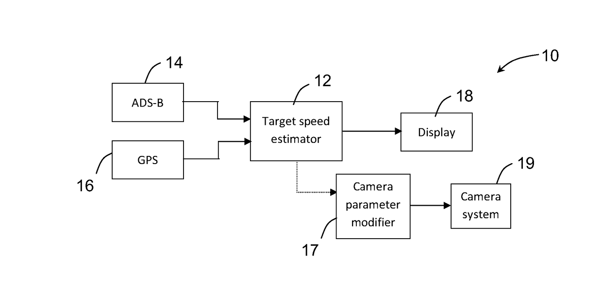
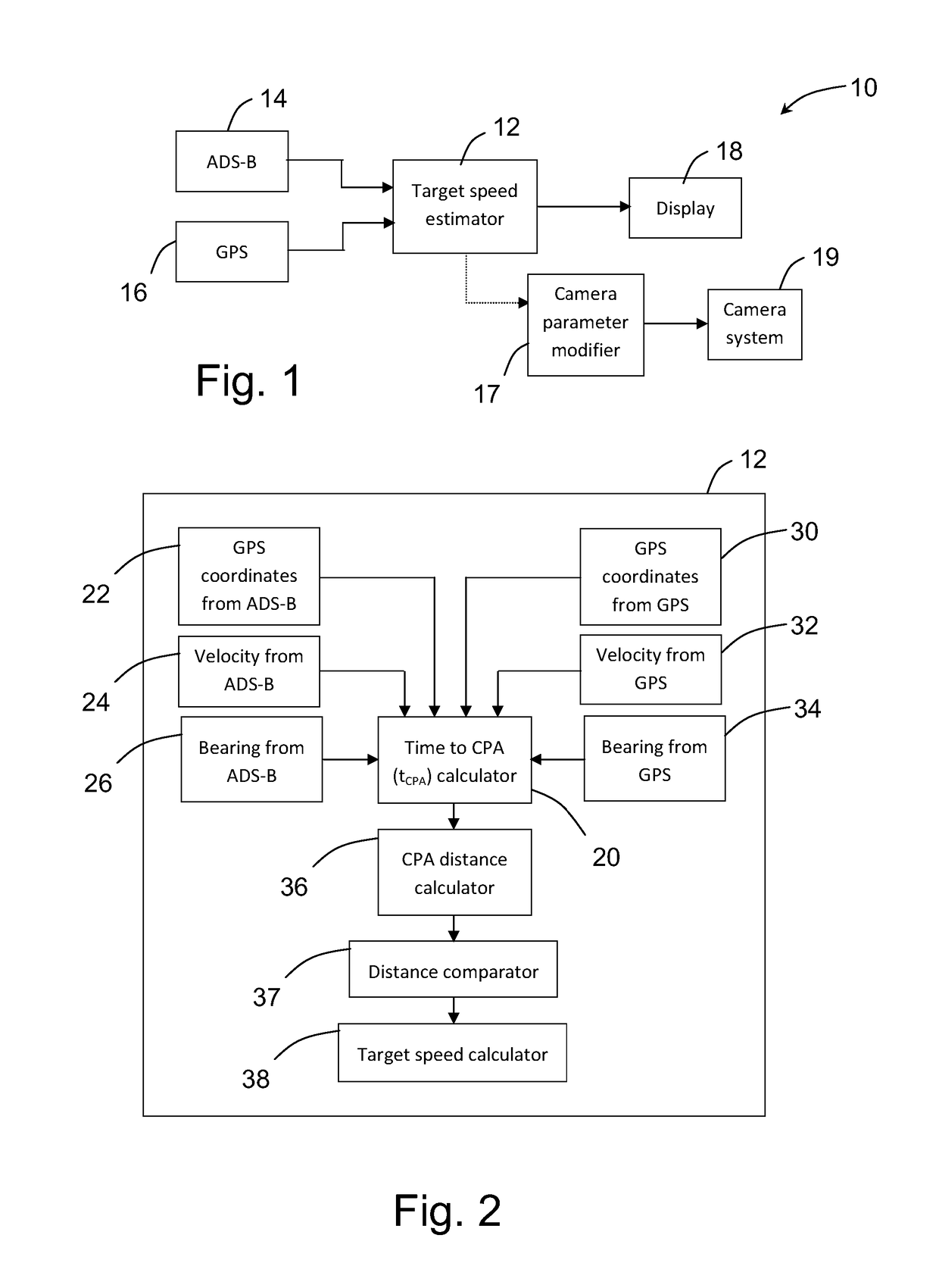
[0068]Automatic Dependent Surveillance-Broadcast (ADS-B) is a cooperative surveillance technology whereby an aircraft determines its position using satellite navigation techniques and periodically broadcasts the position information. The information can be received by air traffic control ground stations as a replacement or supplement for secondary radar. The position information can also be received by other aircraft to provide situational awareness and allow operators of the other aircraft to self-manage the separation distance between the two aircraft.

[0069]The present system uses an ADS-B data receiving device, for example disposed on a survey aircraft, to monitor the identity, position, speed, heading, altitude and rate of climb / descent of all aircraft within the proximity of the survey aircraft, determines whether any of the nearby aircraft are converging with the survey aircraft, and predicts the closest point of approach (CPA) between the survey aircraft and the nearby aircra...


PUM


Abstract

An aerial survey image capture system for a survey aircraft is disclosed. The system comprises a camera system arranged to capture successive images of ground beneath a survey aircraft. The camera system has associated camera parameters, and a loss of separation (LOS) avoidance system for a survey aircraft. The LOS avoidance system is arranged to determine a predicted closest point of approach (CPA) distance between the survey aircraft and the nearby aircraft based on their locations and movements, compare the CPA distance with a defined minimum separation distance corresponding to a LOS and determine an estimate for at least one navigation parameter of the survey aircraft required for the CPA distance to remain above the defined minimum separation distance. The system is further arranged to modify camera system parameters so as to at least partially compensate for a change in survey efficiency when the estimated at least one navigation parameter is used to navigate the survey aircraft.

Description

FIELD OF THE INVENTION[0001]The present invention relates to an aerial survey image capture system for a survey aircraft.BACKGROUND OF THE INVENTION[0002]A survey aircraft typically includes an aerial camera system that is arranged to capture ground images. Typically, the aerial camera system is mounted to an underside portion of the survey aircraft and ground images are captured as the survey aircraft moves along defined flight lines. The system is arranged to capture multiple images for each ground feature, which enables a photogrammetric solution, such as a bundle adjustment process, to be applied to the captured images in order to determine a best case solution for interior and exterior orientation information associated with each camera used and the images captured by each camera. The solution produced by the bundle adjustment process may then be used for further processing, such as 3D reconstruction, and to produce output product such as nadir and / or oblique photomaps and elev...

Claims


Application Information

Patent Timeline
Patent Type & Authority Applications(United States)
IPC IPC(8): G01C11/02G06K9/00G05D1/00G01S19/51G08G5/00
CPCG01C11/02G01S19/51G06K9/0063G08G5/0052G05D1/0055G08G5/0021G03B15/006G08G5/045G08G5/0086G05D1/0094
Inventor COPE, SIMONVON BERTOUCH, MICHAEL
Owner SPOOKFISH INNOVATIONS
Why Eureka
Try Eureka