Matching navigation method based on local gravity field approximation

A navigation method, a gravity field technology, applied in the field of inertial navigation

Inactive Publication Date: 2015-04-22
NAVAL UNIV OF ENG PLA
View PDF3 Cites 0 Cited by
  • Summary
  • Abstract
  • Description
  • Claims
  • Application Information

AI Technical Summary

Problems solved by technology

[0009] The purpose of the present invention is to provide a matching navigation method based on local gravity field approximation, which can not only overcome the influence of the gravimeter measurement data error on the matching navigation accuracy caused by the Utterfors effect, but also compensate The defect that the traditional TERCOM method cannot correct the heading error

Method used


Image

  • Matching navigation method based on local gravity field approximation
  • Matching navigation method based on local gravity field approximation
  • Matching navigation method based on local gravity field approximation

Examples


Embodiment Construction

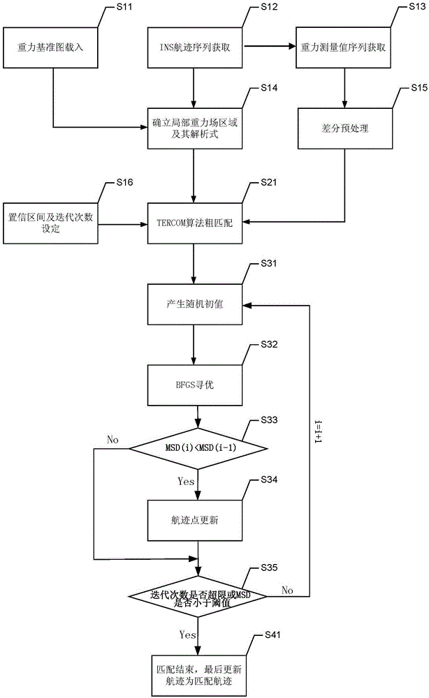
[0043] The present invention will be further described in detail below in conjunction with the drawings and specific embodiments:

[0044] Such as figure 1 The matching navigation method based on local gravity field approximation includes the following steps:

[0045] Step S11: Load the prepared gravity anomaly reference map into the matching navigation system in advance, where the gravity anomaly reference map is a gridded data collection of gravity anomalies;

[0046] Step S12: Obtain the position of the track point indicated by the inertial navigation system within a period of time through the inertial navigation system as the matching initial track;

[0047] Step S13: Obtain the gravity measurement value sequence corresponding to the track point indicated by the inertial navigation system in step S12 through the gravimeter measurement system;

[0048] Step S14: According to the inertial navigation system indicated track and its confidence interval in step 12, intercept a local grid...


PUM


Abstract

The invention discloses a matching navigation method based on local gravity field approximation. The method comprises the following steps that: at first, a flight path indicated by an inertial navigation system in a period of time is acquired as an initial flight path for matching, a gravity abnormal value corresponding to the point of the flight path indicated by the inertial navigation system is acquired, grid data of a local square region are intercepted in a gravity anomaly reference graph through the flight path indicated by the inertial navigation system and a confidence interval thereof, and a function of a gravity anomaly graph of the square region is acquired; and then terrain contour matching algorithm is used for rough matching, difference pretreatment is carried out on a gravity measuring sequence, then rough matching is carried out by using the terrain contour matching algorithm, and matching results are used as an initial flight path for matching algorithm of a related extreme value; and a matching algorithm optimization interval of the related extreme value is acquired based on the rough matching results obtained through terrain contour matching and the confidence interval, an iterative random initial value is generated by an average random number and enters into BFGS for optimization, an optimal matching flight path is calculated based on optimal solution of BFGS optimization, and the original flight path is updated. The method provided by the invention enables available matching precision to be higher through construction of a local gravity field reference graph.

Description

Technical field [0001] The present invention relates to the technical field of inertial navigation, in particular to a matching navigation method based on local gravity field approximation. technical background [0002] Inertial navigation system is a system that uses gyroscopes and accelerometers installed on the carrier to determine the position of the moving carrier. The movement and position of the carrier in the inertial reference coordinate system can be determined through the measurement data of the gyroscope and accelerometer. [0003] The inertial navigation system is autonomous. It does not transmit signals to the outside world or receive signals from the outside world. It is very suitable as a navigation system for underwater vehicles that require concealed navigation. However, the positioning error of the inertial navigation system accumulates over time, which is an important factor restricting the high accuracy of the inertial navigation system during long-distance un...

Claims


Application Information

Patent Timeline
Patent Type & Authority Patents(China)
IPC IPC(8): G01C21/16G01C21/08
Inventor 向才炳蒋东方肖胜红童余德边少锋纪兵
Owner NAVAL UNIV OF ENG PLA
Why Eureka
Try Eureka