A data organization method for urban 3D model suitable for network transmission

A 3D model and network transmission technology, applied in the field of geospatial information systems, can solve problems such as difficulty in meeting user needs and low efficiency of 3D model data visualization, and achieve the effect of improving dynamic scheduling efficiency and improving efficiency

Active Publication Date: 2015-10-28
SHENZHEN INST OF ADVANCED TECH
View PDF1 Cites 0 Cited by
  • Summary
  • Abstract
  • Description
  • Claims
  • Application Information

AI Technical Summary

Problems solved by technology

[0005] The present invention provides a method for organizing 3D model data of a city suitable for network transmission, aiming to solve the problems in the prior art that the visualization efficiency of large-scale 3D model data of a city is low and it is difficult to meet the needs of users

Method used


Image

  • A data organization method for urban 3D model suitable for network transmission
  • A data organization method for urban 3D model suitable for network transmission
  • A data organization method for urban 3D model suitable for network transmission

Examples


Embodiment Construction

[0033] In order to make the object, technical solution and advantages of the present invention clearer, the present invention will be further described in detail below in conjunction with the accompanying drawings and embodiments. It should be understood that the specific embodiments described here are only used to explain the present invention, not to limit the present invention.

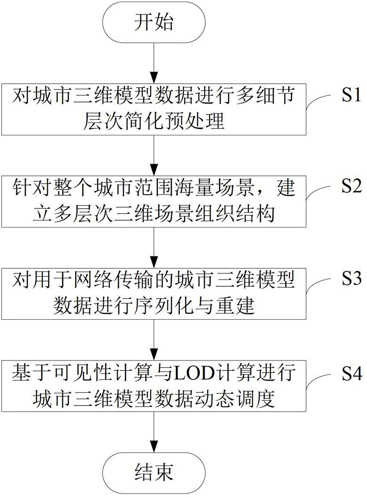
[0034] The embodiment of the present invention provides a method for organizing data of a city three-dimensional model suitable for network transmission, such as figure 1 As shown, the method includes the following steps:

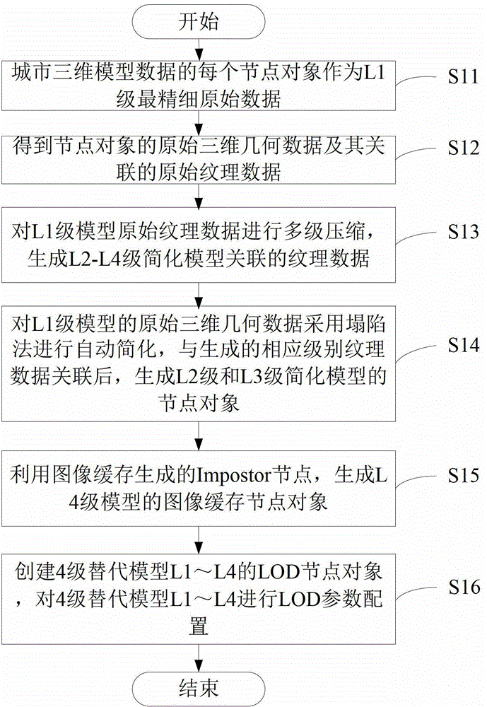
[0035] Step S1: Perform multi-level-of-detail simplified preprocessing on the city 3D model data.

[0036] In this step, LOD (level of detail, level of detail) technology is used for multi-level simplification. A set of surrogate models for pre-calculated geometry, select the appropriate LOD level for rendering at runtime, and reduce the number of patches that need to be rende...


PUM


Abstract

The invention relates to the technical field of geographic space information systems, and provides a city three-dimensional model data organization method. The method comprises the steps of conducting multi-detail and multi-level simplifying pre-process to city three-dimensional model data, establishing a multi-level three-dimensional scene organization structure for a large number of scenes within the range of a whole city, conducting serialization and reestablishment to the three-dimensional model data of network transmission, and conducting dynamic scheduling to the city three-dimensional model data based on visibility computing and level of detail (LOD) computing. Through the establishment of a space index structure of a large number of city three-dimensional model data and automatic multi-detail and multi-level simplification of the city three-dimensional model data, organization optimization is conducted to the three-dimensional model data under the network environment, dynamic scheduling efficiency of the city three-dimensional model data under the network environment is improved, and real-time visual efficiency of the city three-dimensional model data is improved.

Description

technical field [0001] The invention relates to the technical field of geographic space information systems, in particular to a data organization method of a three-dimensional city model. Background technique [0002] A city is a huge complex system. By establishing a three-dimensional digital city that can provide people with all kinds of realistic scene information about the city in an all-round and intuitive way, a three-dimensional and lifelike three-dimensional virtual urban environment is built. In the face of complex cities, managers provide more powerful decision-making tools. With the rapid development of spatial information acquisition technology and 3D modeling technology, the acquisition accuracy and modeling speed of urban 3D model data expressing data content on the ground, surface, and underground have been continuously improved, and the scope of data modeling has been continuously expanded. The increasing nature of data has led to a rapid expansion of its da...

Claims


Application Information

Patent Timeline
Patent Type & Authority Patents(China)
IPC IPC(8): G06T17/05G06F17/30
Inventor 李晓明吕智涵胡金星张宝运李微微康艳丽
Owner SHENZHEN INST OF ADVANCED TECH
Why Eureka
Try Eureka