High-resolution remote sensing image ortho-rectification method based on floating control point

A remote-sensing image and high-resolution technology, applied to instruments, character and pattern recognition, computer components, etc., can solve problems such as difficult application, few ground control points, and difficulty in meeting needs

Active Publication Date: 2014-01-22
SHANGHAI URBAN CONSTR DESIGN RES INST GRP CO LTD
View PDF4 Cites 8 Cited by
  • Summary
  • Abstract
  • Description
  • Claims
  • Application Information

AI Technical Summary

Problems solved by technology

The traditional update method based on field measurements requires a lot of manpower and material resources, and the update method based on satellite high-resolution multispectral remote sensing images can quickly update the channel boundary and the cost is low
However, the ground control points in some areas are relatively rare, and it is impossible to achieve high-precision orthorectification of images
The difficulty brought by the application of this method in channel update, it is difficult to meet the demand, and further improvement is needed

Method used


Image

  • High-resolution remote sensing image ortho-rectification method based on floating control point

Examples


Embodiment Construction

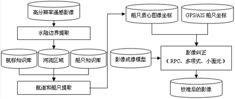
[0019] This embodiment proposes a method for orthorectification of high-resolution remote sensing images based on floating control points, including the following steps:

[0020] In step S101 , water and land boundaries are extracted based on high-resolution remote sensing images, and small targets in the water area are selected as candidate targets for ship recognition.

[0021] Step S102, using texture and reflectance index to describe the candidate target, and constructing a feature vector; exemplary, the feature vector constructed in this embodiment includes gray level co-occurrence matrix statistics, Gabor filter response and spectral reflectance.

[0022] Step S103, selecting ships and pseudo-ships from images of the same type to construct a training and testing sample library, calculating the feature vector described in step S102 for the sample images in the sample library, and adding an output value to the feature vector: the output value of the ship is 1 , the pseudo-...


PUM


Abstract

The invention discloses a high-resolution remote sensing image ortho-rectification method based on a floating control point. The method comprises the steps as follows: step S101, land and water boundary extraction is performed based on a high-resolution remote sensing image, and a small target in water is selected as a candidate target for ship recognition; step S102, a feature vector is established; step S103, a training and testing sample bank is established; step S104, an SVM (support vector machine) or an ANN (artificial neural network) is adopted to finish ship recognition based on a training and testing sample bank training classifier, and image coordinates of the ship are obtained; step S105, morphology subdivision is adopted to obtain a geometric center line of the recognized ship, and matching of AIS (automatic identification system) course of the ship in the tangential direction is finished by the geometric center line, so that accurate GPS (global positioning system) positioning information of the ship is obtained; and step S106, the control point is formed based on image coordinates and geographic coordinates, a rational polynomial correction model of a satellite is optimized, and a high-accuracy ortho-image is obtained.

Description

technical field [0001] The invention relates to the technical field of remote sensing image recognition and correction, in particular to a high-resolution remote sensing image orthorectification method based on floating control points. Background technique [0002] Channel update is an important content in shipping management. The traditional update method based on field measurement requires a lot of manpower and material resources, but the update method based on satellite high-resolution multispectral remote sensing imagery can quickly update the channel boundary and the cost is low. However, there are few ground control points in some areas, and it is impossible to achieve high-precision orthorectification of images. The application of this method in channel update brings difficulties, it is difficult to meet the demand, and further improvement is needed. Contents of the invention [0003] In view of the above-mentioned shortcomings of the prior art, the present invent...

Claims


Application Information

Patent Timeline
Patent Type & Authority Applications(China)
IPC IPC(8): G06K9/32
Inventor 丁美张慧哲周良蒋应红沈日庚
Owner SHANGHAI URBAN CONSTR DESIGN RES INST GRP CO LTD
Why Eureka
Try Eureka