An Annotation Generation Method for Soil Spatial Data Mapping

A technology of spatial data and annotation, applied in the field of agricultural and resource environment spatial information, can solve the problem of massive data without soil map

Inactive Publication Date: 2017-03-22
INST OF AGRI RESOURCES & REGIONAL PLANNING CHINESE ACADEMY OF AGRI SCI
View PDF5 Cites 0 Cited by
  • Summary
  • Abstract
  • Description
  • Claims
  • Application Information

AI Technical Summary

Problems solved by technology

[0004] At present, there are no ready-made tools or algorithms to realize the annotation of massive data in soil maps

Method used


Image

  • An Annotation Generation Method for Soil Spatial Data Mapping

Examples


Embodiment Construction

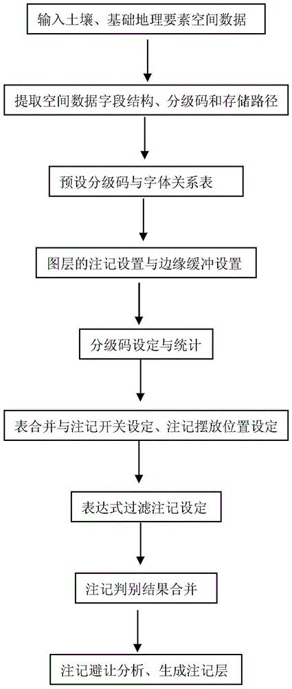
[0029] The present invention will be described in further detail below in conjunction with the accompanying drawings, and the method flow chart of the present invention is shown in the figure.

[0030] A notation method for massive soil spatial data mapping, the steps of which are:

[0031] 1) Prepare soil and basic geospatial data. If the data is in Coverage or Shape format, it is required to convert the data format to File GDB (File Geodatabase) database format, and the required data layers are stored in the File GDB database; if The soil and basic geographic information data are already in the File GDB database format, so there is no need to convert them, and you can go directly to step 2. File Geodatabase is a data model that ArcGIS adopts standard relational database technology to represent geographic information. It supports storage and management of geographic information, multiple DBMS structures, and multi-user access. Soil and basic geospatial data are stored in thr...


PUM


Abstract

The invention discloses a method for generating notes of a soil spatial data graph. The method includes the first step of generating a structural table, a grading code table and a storage path table according to a database; the second step of establishing a grading code and typeface relational table V_GrTxt; the third step of carrying out note setting and edge buffering setting on a map layer according to the structural table, generating a table Vlay and selecting grading code fields needing counting to count grading codes; the fourth step of merging the grading code table with the table Vlay and the table V_GrTxt and generating a grading code table V2_Gr, wherein the grading code table V2_Gr is provided with a GrOff field determining whether notes are generated or not and a Curve field setting the arrangement direction in which the notes are generated; the fifth step of screening the grading codes in the table V2_Gr according to a statistic result and determining whether the grading codes generate the notes or not; the sixth step of merging distinguish results, generating a grading code table V4_Leg of the notes and generating a note layer according to the Curve field and the table V_GrTxt. The method achieves automatic receding and generation of the notes.

Description

technical field [0001] The invention relates to a method for noting in the process of drawing a soil map, and belongs to the technical field of agriculture, resources and environment space information. Background technique [0002] Since the founding of the People's Republic of my country, the first and second national soil surveys have been completed, and a large number of soil maps have been accumulated. These maps visually express and display soil physical and chemical properties such as soil type, texture, pH, nutrient and fertility status in the form of maps. The spatial distribution of traits is the concentrated expression of soil survey results, and large-scale soil maps are an important basis for modern agricultural and environmental science research. In the process of large-scale soil map drawing, soil annotation is an important content of soil map cartographic expression, including soil type names, place names, and names of geographical elements such as water system...

Claims


Application Information

Patent Timeline
Patent Type & Authority Patents(China)
IPC IPC(8): G06F17/30
CPCG06F16/29
Inventor 雷秋良张维理张认连徐爱国武淑霞冀宏杰张怀志岳现录龙怀玉张继宗曹祥会杨卓张亦涛徐明月
Owner INST OF AGRI RESOURCES & REGIONAL PLANNING CHINESE ACADEMY OF AGRI SCI
Why Eureka
Try Eureka