Rural collective land property right information investigation system and rural collective land property right information investigation method

An information survey and land technology, applied in instruments, data processing applications, computing, etc., can solve problems such as low efficiency, lagging rural collective land property rights management technology, and less research on rural collective land distribution, use and changes. The effect of improving efficiency

Inactive Publication Date: 2015-05-20
CHINA UNIV OF GEOSCIENCES (BEIJING)
View PDF3 Cites 16 Cited by
  • Summary
  • Abstract
  • Description
  • Claims
  • Application Information

AI Technical Summary

Problems solved by technology

[0002] So far, although my country has carried out the second detailed land survey and accurately grasped the area and use of various types of land in our country, there are few studies on the distribution, use and changes of rural collective land, and the rural collective land Property rights management technology is lagging behind
For example, after rapid urbanization, the use of rural collective land often changes. However, the management department generally uses manual measurement and manual entry to record the changes in the property rights of each land, which has the problem of low efficiency.

Method used


Image

  • Rural collective land property right information investigation system and rural collective land property right information investigation method
  • Rural collective land property right information investigation system and rural collective land property right information investigation method
  • Rural collective land property right information investigation system and rural collective land property right information investigation method

Examples


Embodiment Construction

[0035] The present invention is described in detail below in conjunction with accompanying drawing:

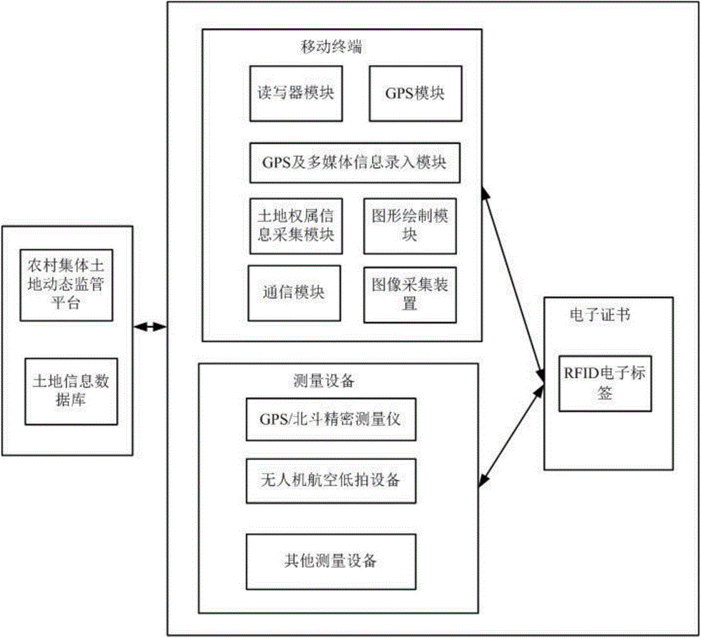
[0036] Such as figure 1 As shown, the present invention provides a rural collective land property right information investigation system, including: mobile terminal, measuring equipment, electronic certificate, rural collective land dynamic supervision platform and land information database. The following are detailed introductions:

[0037] (1) Electronic certificate

[0038] The electronic certificate is an electronic certificate of land ownership, with a built-in RFID electronic tag for storing basic land information; basic land information includes but not limited to land ownership information, land changes, cadastral maps, and cadastral spatial information.

[0039] The built-in RFID electronic tag of the electronic certificate can effectively improve the anti-counterfeiting function of the electronic certificate. Specifically, the application of RFID in the field of an...


PUM


Abstract

The invention provides a rural collective land property right information investigation system and a rural collective land property right information investigation method. The rural collective land property right information investigation system comprises a mobile terminal, measuring equipment, an electronic certificate, a dynamic rural collective land supervisory platform and a land information database, wherein the electronic certificate is a land property electronic certificate; an electronic tag is placed in the electronic certificate; the measuring equipment is used for measuring land registration space information of an investigated land; the mobile terminal comprises a reader-writer module, a GPS (global positioning system) and multimedia information entry module, a land property information acquiring module, a graphic drawing module, a communication module, a GPS module and an image acquiring device; and the dynamic rural collective land supervisory platform is used for comprehensively managing and maintaining states of lands. The high-precision measuring equipment is used for measuring rural collective lands; parcel maps can be drawn and attribute information can be displayed on the spot, and land information is recorded through the electronic tag; and the dynamic land supervisory platform is used for performing routine maintenance on the land database, and the land investigation efficiency is improved comprehensively.

Description

technical field [0001] The invention belongs to the technical field of information collection, processing and analysis, and in particular relates to a rural collective land property right information investigation system and method. Background technique [0002] So far, although my country has carried out the second detailed land survey and accurately grasped the area and use of various types of land in our country, there are few studies on the distribution, use and changes of rural collective land, and the rural collective land Property rights management technology is also lagging behind. For example, after rapid urbanization, the use of rural collective land often changes. However, management departments still generally use manual measurement and manual entry methods to record the changes in land property rights, which has low efficiency. Contents of the invention [0003] Aiming at the defects existing in the prior art, the present invention provides a rural collective ...

Claims


Application Information

Patent Timeline
Patent Type & Authority Applications(China)
IPC IPC(8): G06Q50/26
CPCG06Q50/26
Inventor 郑新奇王庆贾宗仁孙义博艾刚
Owner CHINA UNIV OF GEOSCIENCES (BEIJING)
Why Eureka
Try Eureka