A method of intercepting Google Earth image and directly applying it to engineering design

A technology of Google Earth and engineering design, applied in special data processing applications, calculations, instruments, etc., to achieve the effect of facilitating design work

Active Publication Date: 2019-03-15
CEEC JIANGSU ELECTRIC POWER DESIGN INST
View PDF3 Cites 0 Cited by
  • Summary
  • Abstract
  • Description
  • Claims
  • Application Information

AI Technical Summary

Problems solved by technology

[0003] At present, there is no method to directly convert the spherical image of Google Earth into a plane image in the local engineering coordinate system and successfully apply it to engineering design

Method used


Image

  • A method of intercepting Google Earth image and directly applying it to engineering design
  • A method of intercepting Google Earth image and directly applying it to engineering design
  • A method of intercepting Google Earth image and directly applying it to engineering design

Examples


Embodiment Construction

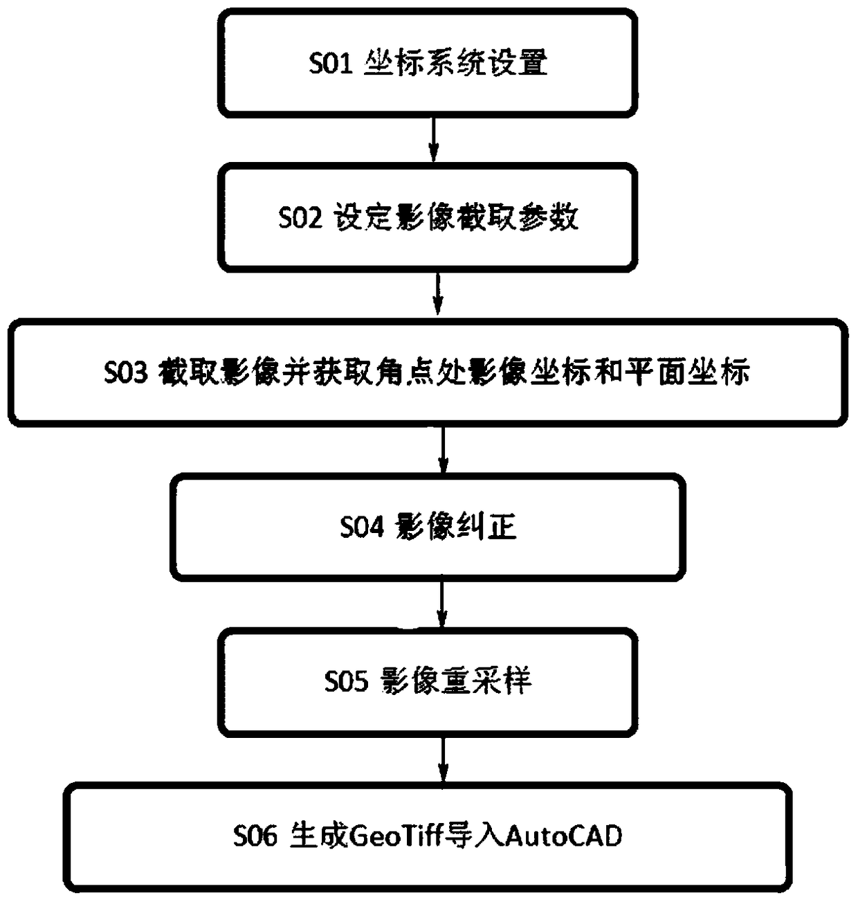
[0025] The present invention will be further described below in conjunction with the accompanying drawings. The following examples are only used to illustrate the technical solution of the present invention more clearly, but not to limit the protection scope of the present invention.

[0026] Such as figure 1 As shown, a method of intercepting Google Earth images and directly applying them to engineering design includes the following steps:

[0027] Step 1), set the project coordinate system: input the ellipsoid corresponding to the project, input the projection parameters including the central meridian, the assumed east coordinate, and the assumed north coordinate, and input the WGS84 corresponding to Google Earth and the Bursa model parameters of the corresponding coordinate system of the project including the translation amount DX, DY, DZ and rotation amount RX, RY, RZ and scale ratio K.

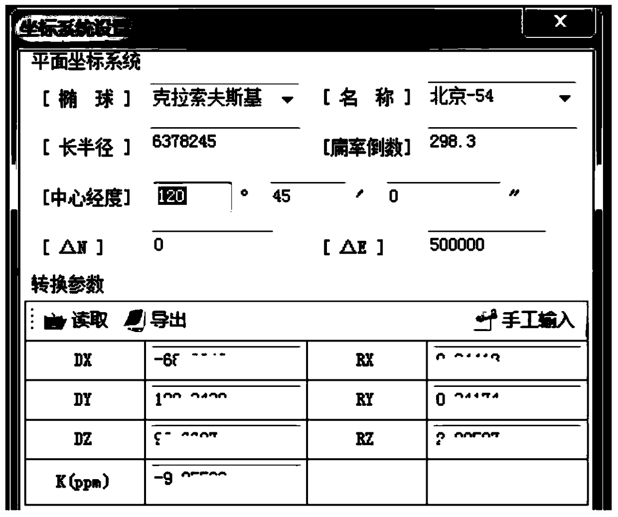
[0028] Such as figure 2 The coordinate system parameters corresponding to the pro...


PUM


Abstract

The invention discloses a method for intercepting a google earth image and directly applying in engineering design. The method is characterized by comprising the following steps of 1), setting a coordinate system; 2), setting an image intercepting parameter; 3) intercepting the image and acquiring an image coordinate and a plane coordinate at a corner point; 4) performing biquadratic polynomial geometric correction and least square precision determination on homonymy points of the image according to a coordinate file; 5) performing re-sampling on an original image which satisfies a precision requirement according to a correction result according to a nearest neighbor interpolation method; and 6), automatically introducing a generated image into AutoCAD according to a geographic information tfw file for engineering design by designing personnel. The method provided by the invention has beneficial effects of conveniently and quickly intercepting the google earth image on condition that no topographical map exists or the verisimilitude of the topographical map is relatively low, realizing no requirement for fieldwork measurement in manufacturing a high-precision orthoimage, and facilitating early-period smooth design operation of engineering design personnel.

Description

technical field [0001] The invention relates to a method for directly applying an intercepted Google Earth image to engineering design, belonging to the technical field of engineering design. Background technique [0002] In the preliminary stage of engineering design feasibility study of electric power, railways and highways, engineering designers usually rely on topographic maps with a scale of 1:10000 for engineering design. In recent years, Google Earth has been widely used in the engineering design industry due to its high image resolution and strong current situation. Engineering designers need to intercept images through software, select a certain number of image control points with distinct characteristics in the intercepted images, and use field GPS After geometric correction, the orthophoto with geographic grid lines is generated and then inserted into AutoCAD for auxiliary design work. Although the accuracy of this working method can meet the requirements, it is ...

Claims


Application Information

Patent Timeline
Patent Type & Authority Patents(China)
IPC IPC(8): G06F17/50
Inventor 陈正宇徐君民李欣王骢伍根杨晓慧
Owner CEEC JIANGSU ELECTRIC POWER DESIGN INST
Why Eureka
Try Eureka