
Related methods and devices for progressive transmission of spatial data

A technology of spatial data and transmission methods, applied in image data processing, instruments, electrical components, etc., can solve problems such as inability to achieve adaptive progressive transmission, low compression ratio, and reduced data volume, and achieve lossless display and large compression. the effect of

Active Publication Date: 2016-08-24
SUZHOU SUPERENGINE FOR GRAPHICS & IMASOFTWARE TECH DEV
View PDF5 Cites 0 Cited by
  • Summary
  • Abstract
  • Description
  • Claims
  • Application Information

AI Technical Summary

Problems solved by technology

If the resolution of spatial data display is between the two divided layers, the display will be distorted, and progressive transmission of lossless display cannot be realized, that is, adaptive progressive transmission cannot be achieved
In addition, the current progressive transmission of spatial data adopts the progressive transmission method of coordinate points, and the progressive transmission of coordinate point data according to data bits is not realized. The compression of incremental data only adopts the usual compression method, such as ZIP compression, and the compression ratio is low. , does not consider the spatial relationship between the previously cached spatial data and the progressively transmitted incremental data, further reducing the amount of data
[0010] It can be seen from the above that it cannot ensure that the vector data itself and the spatial relationship between the vector data are always correctly displayed during the process of compression and progressive transmission of arbitrarily complex vector data, which restricts the practical application of vector data compression and progressive transmission technology

Method used


Image

  • Related methods and devices for progressive transmission of spatial data
  • Related methods and devices for progressive transmission of spatial data
  • Related methods and devices for progressive transmission of spatial data

Examples


Embodiment 1

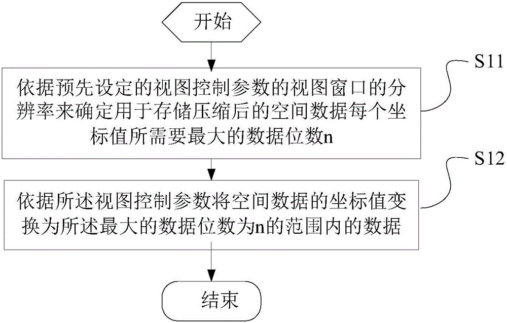
[0074] The flow of a method embodiment of spatial data compression disclosed by the present invention is as follows: figure 1 As shown, this embodiment includes:

[0075] Step S11. Determine the maximum number of data bits n required for storing each coordinate value of the compressed spatial data according to the preset view control parameters;

[0076] The view control parameter in the present embodiment comprises: the outer rectangle parameter of view window, the outer rectangle parameter of view window is the view window range (0,0, ViewWidth, ViewHeight) of display space entity, as the scope of computer screen map display window, Including: the width ViewWidth of the outer rectangle of the view window and the height ViewHeight of the outer rectangle of the view window. Through these two parameters, the size range of the window used to display graphics and images in the actual view window can be determined.

[0077] Calculate the maximum value in the width and height of t...

Embodiment 2

[0083] The display of spatial data is to perform a series of coordinate transformations on the coordinate values ​​of the coordinate points of the spatial data, transform them into pixel coordinates under the view window, and then draw them into a raster image through a drawing algorithm and display it on the screen.

[0084] The process of transforming the original coordinates of the spatial data into the view coordinates on the view window is as follows, assuming that the enclosing rectangle of the view window is ViewRect(0, 0, W, H), where W is the width of the enclosing rectangle, and H is The height of the outer rectangle, the magnification ratio of the spatial data in the view is R, and the rectangular range of the spatial data displayed in the view window is (the minimum value of the X axis gxmin, the minimum value of the Y axis gymin, the maximum value of the X axis gxmax, the Y axis maximum value gymax), then the central point CP (cx, cy) of the rectangular range of th...

Embodiment 3

[0112]In the above embodiment, after compressing the spatial data, it is necessary to determine the maximum number of data digits for storing the compressed spatial data. Therefore, the present invention discloses a method for determining the maximum number of data digits for storing the compressed spatial data, that is, according to The maximum value of the width and height of the view window in the preset view control parameters is used to determine the maximum number of data bits n required for each coordinate value of the compressed spatial data. That is to say, the maximum number of data bits to be stored after the compressed spatial data displayed in the view window is determined by the width and height of the view window. Specifically, the present invention preferably determines n in the following manner: first obtain the largest value among the width and height of the view window of the view control parameter, and then multiply the largest value by the number of data bi...


PUM


Abstract

The invention discloses methods and devices for compression, decompression and progressive transmission of spatial data. The compression method for spatial data comprises: obtaining a compression parameter Z according to a preset view control parameter; determining a reference point P according to the view control parameter; transforming the coordinate value of a coordinate point of spatial data and the coordinate value of the reference point P into integers according to the compression parameter Z; and making difference between the value after the coordinate value of the coordinate point of the spatial data is transformed into an integer and the value after the coordinate value of the reference point P is transformed into an integer as compressed data. The invention further discloses a method for determining a maximum data bit for storing spatial data, an interpolation method for incremental data, compression and decomposition methods for incremental data and devices thereof. The methods and the devices can solve the problems that the existing methods for compression and progressive transmission of spatial data are large in calculation quantity and low in efficiency, the spatial relation among all the compressed spatial data cannot be guaranteed to display accurately and the like.

Description

[0001] This application is a divisional application with the filing date of April 18, 2013, the application number: 201310136682.4, and the title of the invention: methods and devices related to spatial data compression, decompression, and progressive transmission. This application claims the priority of the Chinese patent application submitted to the China Patent Office on April 18, 2012, the application number is: 201210114177.5, and the title of the invention is: method and device for spatial data compression, decompression and progressive transmission, and the entire content is passed References are incorporated in this application. technical field [0002] The present invention relates to the fields of spatial information technology, computer graphics and computer operating systems, and in particular to methods and devices for compressing, decompressing and progressively transmitting spatial data, and a method for determining the maximum data bit for storing compressed spa...

Claims


Application Information

Patent Timeline
Patent Type & Authority Applications(China)
IPC IPC(8): G06T9/00H03M7/30
CPCG06T9/005H03M7/30G06T9/00
Inventor 董福田
Owner SUZHOU SUPERENGINE FOR GRAPHICS & IMASOFTWARE TECH DEV
Learn More