Working method of real scene navigation system

A technology of a navigation system and a working method, which is applied in the field of navigation, can solve the problems of lag of the navigator's instruction navigation indication image, the driver's wrong driving route, and the low precision of the navigation signal, and achieves good guidance, improved work reliability, and real-time performance. Good results

Active Publication Date: 2016-10-19
保定烧云信息技术有限公司
View PDF7 Cites 11 Cited by
  • Summary
  • Abstract
  • Description
  • Claims
  • Application Information

AI Technical Summary

Problems solved by technology

[0002] In the actual navigation process of the navigator, due to the untimely update of the map and the low accuracy of the navigation signal, the vehicle travels to a complex intersection (referring to a roundabout with multiple intersections, a cross-shaped fork, a rice-shaped intersection, and an urban elevated road). When going up the crossing, etc.), the instructions of the navigator or the navigation instruction image often lag behind, or even make mistakes, or the navigation image is difficult to accurately match the actual road conditions, which easily causes the driver to enter the wrong driving route

Method used


Image

  • Working method of real scene navigation system
  • Working method of real scene navigation system
  • Working method of real scene navigation system

Examples


Embodiment 1

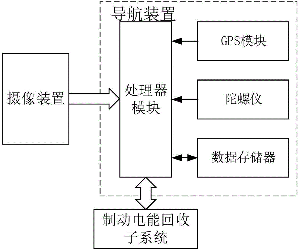
[0031] figure 1 A functional block diagram of the real scene navigation system of the present invention is shown.

[0032] Such as figure 1 As shown, the present invention provides a working method of a navigation system. The navigation system includes: a navigation device and an imaging device; the navigation device includes: a gyroscope for obtaining the driving direction of the vehicle, and a A GPS module, a data memory for storing map data and street view data, and a processor module and a display module.

[0033] The working method includes: when the vehicle is traveling on a preset navigation route, the camera device follows the vehicle to capture the real-time scene around the current vehicle in real time; if there is a complex intersection ahead, the processor module compares the real-time scene with the matching the street view of the corresponding position prestored in the data memory, and judging the position, road, and correct driving direction of the current veh...

Embodiment 2

[0045] On the basis of Embodiment 1, the present invention also provides a vehicle using the above-mentioned navigation system.

[0046] The vehicle is an electric vehicle; the vehicle is equipped with a braking electric energy recovery subsystem, and the braking electric energy recovery subsystem is connected to a navigation device, and the navigation device is also suitable for calculating The passing speed of the replanned route is obtained to obtain the remaining mileage of the battery in the braking electric energy recovery subsystem. A specific processor module can realize the function of calculating the remaining mileage.

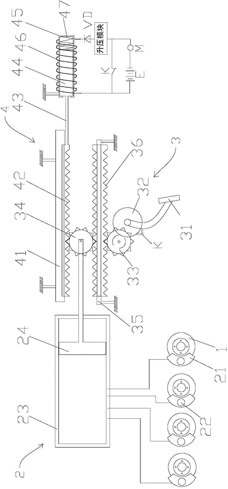
[0047] figure 2 A schematic structural diagram of the braking electric energy recovery subsystem of the present invention is shown.

[0048] Such as figure 2 As shown, the brake electric energy recovery subsystem includes a hydraulic brake mechanism 2 and a brake coordinating assembly 4 that cooperates with the hydraulic brake mechanism 2; when ...

Embodiment approach

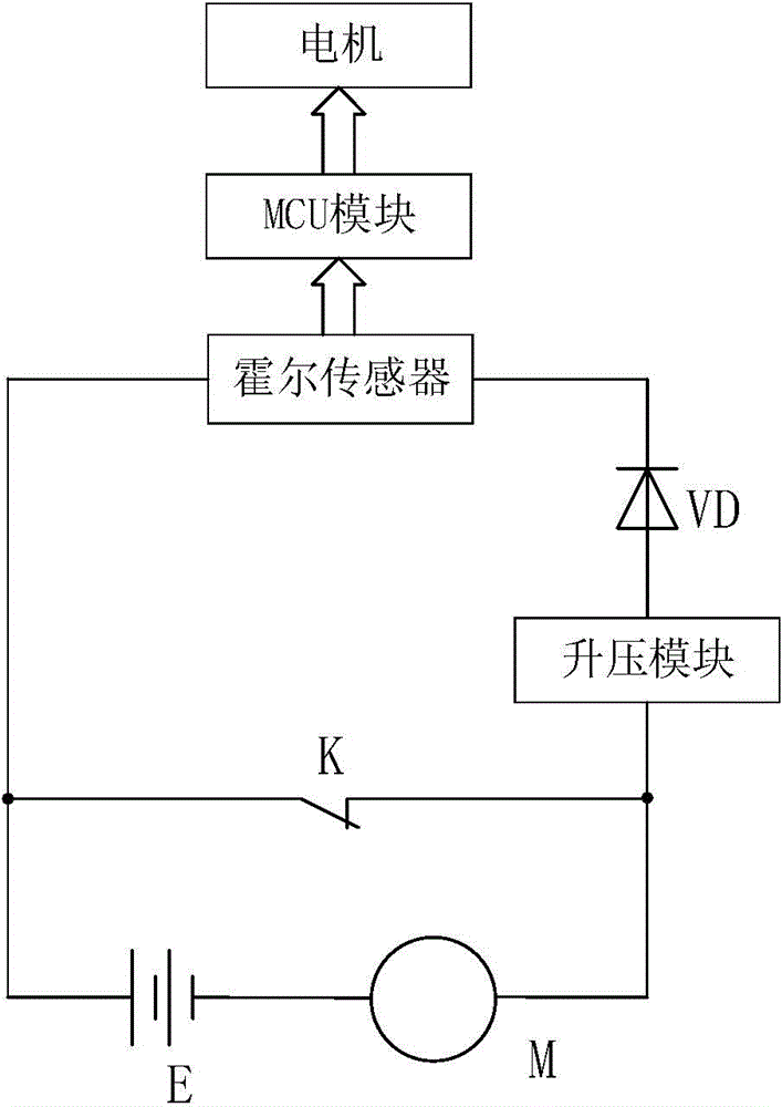
[0061] Specific implementation manner: the charging circuit includes a diode VD; the positive pole of the battery E is connected to one end of the electromagnetic coil 46, the other end of the battery coil is connected to the cathode of the diode VD, and the anode of the diode VD is connected to the boost voltage The output end of the module is connected, the input end of the boost module is connected to one end of the wheel drive motor M, the negative pole of the battery E is connected to the other end of the wheel drive motor M; the auxiliary switch is a normally closed switch, and the normally closed Both ends of the switch are respectively connected to the input end of the boost module and the positive pole of the storage battery E.

[0062] The unidirectional characteristic of the diode VD can effectively prevent the battery E from continuing to discharge the wheel drive motor M through the electromagnetic coil 46 after the normally closed switch is turned on; and the char...


PUM


Abstract

The invention relates to a working method of a real scene navigation system. A navigation system comprises the following components: a navigation apparatus and multiple camera devices which are arranged at periphery of a vehicle. A navigation apparatus comprises the following components: a gyroscope for obtaining a driving direction of the vehicle; a GPS module for obtaining a driving position of the vehicle; a data storage device for storing map data and street scenery data; and a processor module and a display module. Light shields are arranged on lenses of the camera devices. When the vehicle drives according to a preset navigation path, the camera devices shoot real-time scene surrounding the vehicle at present along with the vehicle; if complex crossings exist in front, the processor module matches the real-time scene with a street scene of the corresponding position which is prestored in the data storage device, and at the same time the preset navigation path is combined, and the current position, the path, and the correct driving direction of the vehicle are judged; the display module is controlled in order to display corresponding navigation images.

Description

technical field [0001] The invention relates to the field of navigation, in particular to a working method of a real-scene navigation system. Background technique [0002] In the actual navigation process of the navigator, due to the untimely update of the map and the low accuracy of the navigation signal, the vehicle travels to a complex intersection (referring to a roundabout with multiple intersections, a cross-shaped fork, a rice-shaped intersection, and an urban elevated road). When going up the intersection of crossings, etc.), the instructions of the navigator or the navigation instruction image are often lagging behind, or even wrong, or the navigation image is difficult to accurately match the actual road conditions, which easily causes the driver to drive into the wrong driving route. How to avoid the above-mentioned technical problems is a technical problem in the navigation field. Contents of the invention [0003] The purpose of the present invention is to pr...

Claims


Application Information

Patent Timeline
Patent Type & Authority Applications(China)
IPC IPC(8): G01C21/36G01C21/30B60L7/10
CPCB60L7/10G01C21/30G01C21/3647Y02T10/70Y02T10/7072Y02T90/14Y02T90/16
Inventor 不公告发明人
Owner 保定烧云信息技术有限公司
Why Eureka
Try Eureka