
A method of combining remote sensing and meteorological data to obtain all-weather evapotranspiration

A technology of meteorological data and remote sensing data, applied in the field of remote sensing, can solve problems such as not being able to obtain all-weather evapotranspiration

Active Publication Date: 2019-12-24
INST OF AGRI RESOURCES & REGIONAL PLANNING CHINESE ACADEMY OF AGRI SCI
View PDF5 Cites 0 Cited by
  • Summary
  • Abstract
  • Description
  • Claims
  • Application Information

AI Technical Summary

Problems solved by technology

[0004] In view of this, the present invention aims at the problem of not being able to obtain all-weather evapotranspiration in the prior art, and provides a method of combining remote sensing and meteorological data to obtain all-weather evapotranspiration. The present invention combines existing remote sensing data and grid meteorological data The product directly obtains all-weather evapotranspiration, which can effectively provide real-time and reliable parameters for research and application in the fields of regional scale climate, hydrology and ecological environment, and has very important application value

Method used


Image

  • A method of combining remote sensing and meteorological data to obtain all-weather evapotranspiration
  • A method of combining remote sensing and meteorological data to obtain all-weather evapotranspiration
  • A method of combining remote sensing and meteorological data to obtain all-weather evapotranspiration

Examples


Embodiment 1

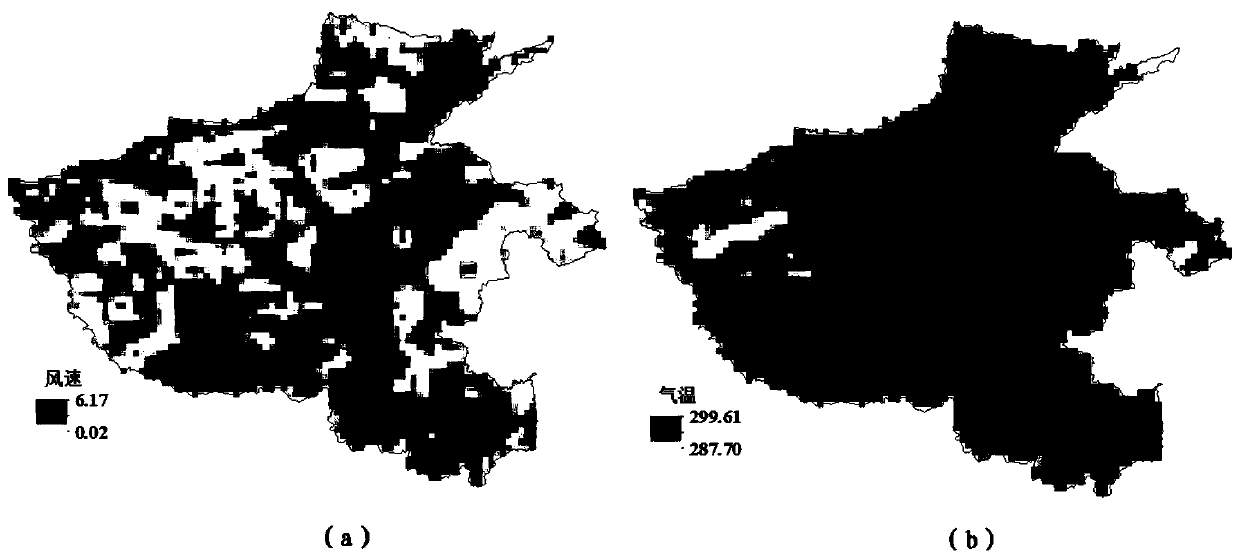
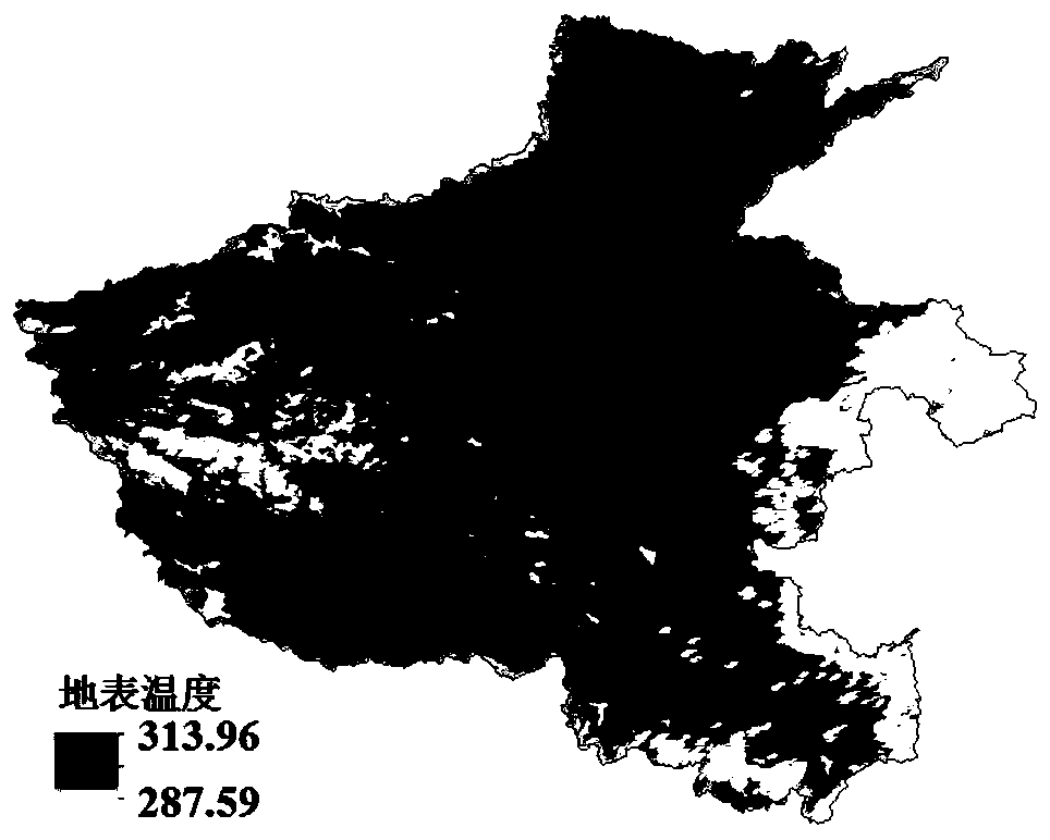
[0106] Taking Henan Province as the research area, figure 2 It is the meteorological data of the study area at 10:00 on April 29, 2015 cut out after downloading the CLDAS grid meteorological data. image 3 is the MODIS Land Surface Temperature (LST) product for the same day, from image 3 It can be seen that on this day, many places, especially the eastern region, showed large white blank areas due to the influence of unfavorable factors such as clouds. There was no normal temperature value, and the temperature was discontinuous. These places could not normally use remote sensing methods to reflect Therefore, traditional remote sensing inversion methods cannot be used to obtain all-weather evapotranspiration. Figure 4 is the result of evapotranspiration inversion. It can be seen from the figure that the traditional method is helpless in the place where there is no pixel value, and cannot obtain evapotranspiration; the method of the present invention can effectively make up...

Embodiment 2

[0108] Taking Henan Province as the research area, Figure 5 It is the meteorological data of the study area at 10:00 on May 12, 2015, which was cut out after downloading the CLDAS grid meteorological data. Image 6 It is the MODIS data of the day. It can be seen from the figure that some areas in the central part of Henan are blank and valueless areas. Figure 7 is the result of evapotranspiration inversion. Figure 7 (a) is the inversion result of the traditional remote sensing method. It can be seen from the figure that the traditional method cannot obtain evapotranspiration where there is no pixel value; Figure 7 (b) is the result of the method of the present invention.

[0109] It can be seen from the results of Example 2 that the method of the present invention can effectively make up for the problem that traditional optical and thermal infrared remote sensing cannot invert evapotranspiration due to unfavorable meteorological factors such as clouds, and can realize al...


PUM


Abstract

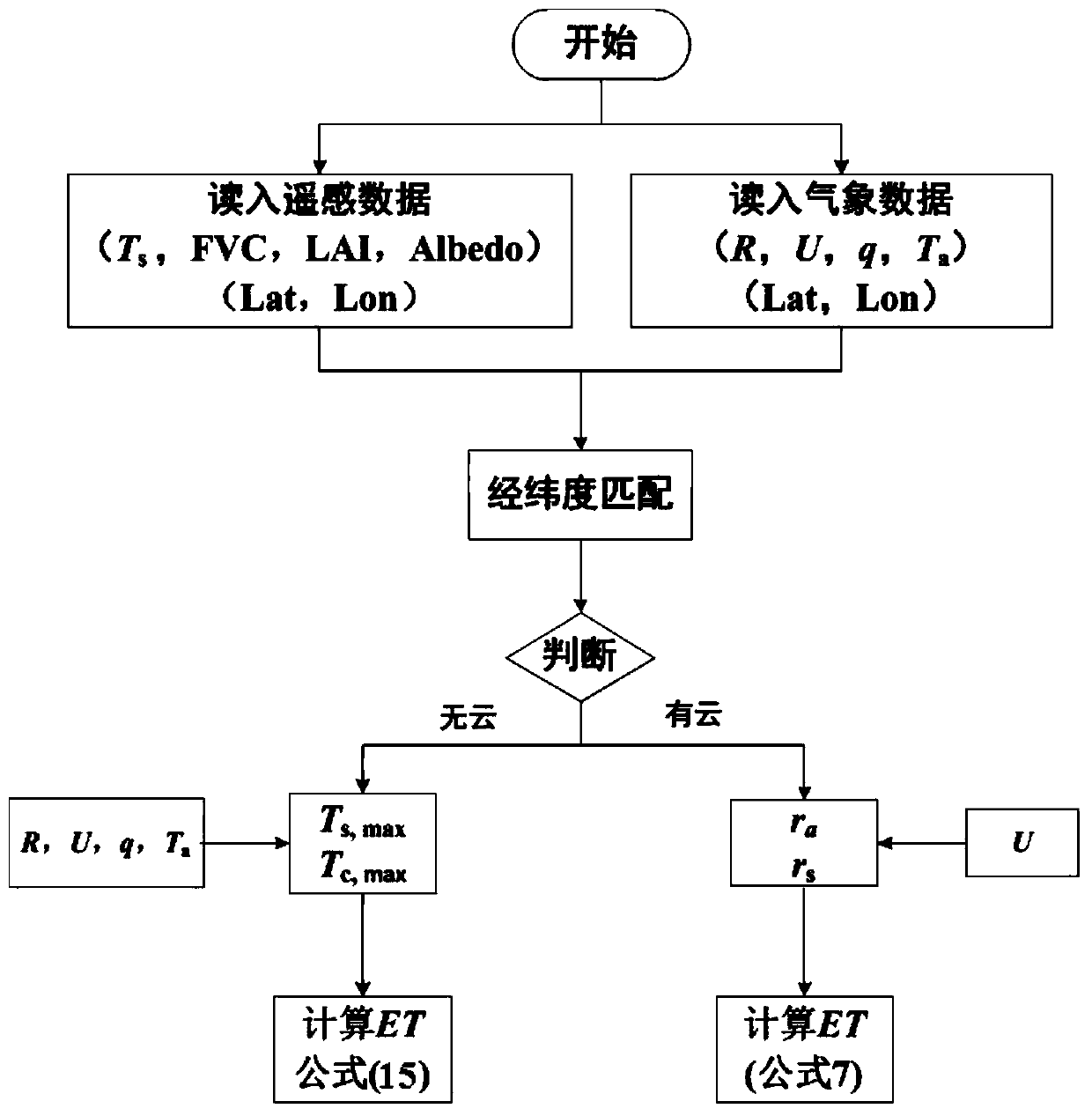
The invention discloses a method of acquiring all-weather evapotranspiration by combining remote sensing and meteorological data, which comprises the following steps: remote sensing data are acquired; meteorological data are acquired; the CLDAS (China Meteorological Administration Land Data Assimilation System) data grid position to which each MODIS (Moderate Resolution Imaging Spectroradiometer) remote sensing pixel belongs is calculated for longitude and latitude matching; MODIS remote sensing pixels are traversed, whether a MODIS land surface temperature pixel contains a cloud is judged, and according to a judgment result, evapotranspiration of an MODIS cloud pixel and evapotranspiration of an MODIS cloudless pixel are estimated. The existing optical and thermal infrared remote sensing data are made full use of, the grid meteorological data are used, the defect that evapotranspiration can not be inversed in a cloud condition by purely using remote sensing data can be remedied, and all-weather evapotranspiration data can be provided.

Description

technical field [0001] The invention belongs to the technical field of remote sensing, and in particular relates to a method for obtaining all-weather evapotranspiration by combining remote sensing and meteorological data. Background technique [0002] Evapotranspiration is an important part of land surface energy balance, and it is of great significance to many fields such as climate change, hydrological cycle and ecological environment. The traditional method of obtaining evapotranspiration is mainly based on point observation, but the spatial representation of point observation data is poor, and it is difficult to reflect the temporal and spatial changes of regional evapotranspiration. At present, in remote sensing evapotranspiration monitoring, optical and thermal infrared remote sensing data are mainly used. However, optical and thermal infrared remote sensing require clear sky and cloudless weather conditions. Once encountering clouds, normal surface parameters cannot...

Claims


Application Information

Patent Timeline
Patent Type & Authority Patents(China)
IPC IPC(8): G01W1/00
CPCG01W1/00
Inventor 冷佩李召良宋小宁段四波高懋芳
Owner INST OF AGRI RESOURCES & REGIONAL PLANNING CHINESE ACADEMY OF AGRI SCI
Learn More