Method and system for sea-sky-line detection and navigation via unmanned surface vehicle (USV) based on vision

A technology of antenna detection and navigation methods, applied in surveying and mapping, navigation, navigation, navigation calculation tools, etc., can solve problems such as difficulty, incomplete sea antenna, and easy interference of sea antenna detection

A technology of antenna detection and navigation methods, applied in surveying and mapping, navigation, navigation, navigation calculation tools, etc., can solve problems such as difficulty, incomplete sea antenna, and easy interference of sea antenna detection

CN107941220AActive Publication Date: 2018-04-20航天时代(青岛)海洋装备科技发展有限公司

Image

  • Method and system for sea-sky-line detection and navigation via unmanned surface vehicle (USV) based on vision
  • Method and system for sea-sky-line detection and navigation via unmanned surface vehicle (USV) based on vision
  • Method and system for sea-sky-line detection and navigation via unmanned surface vehicle (USV) based on vision

Examples


Embodiment Construction

[0071] In order to make the purpose, technical solution and advantages of the present invention clearer, the following will further describe the public implementation manners of the present invention in detail with reference to the accompanying drawings.

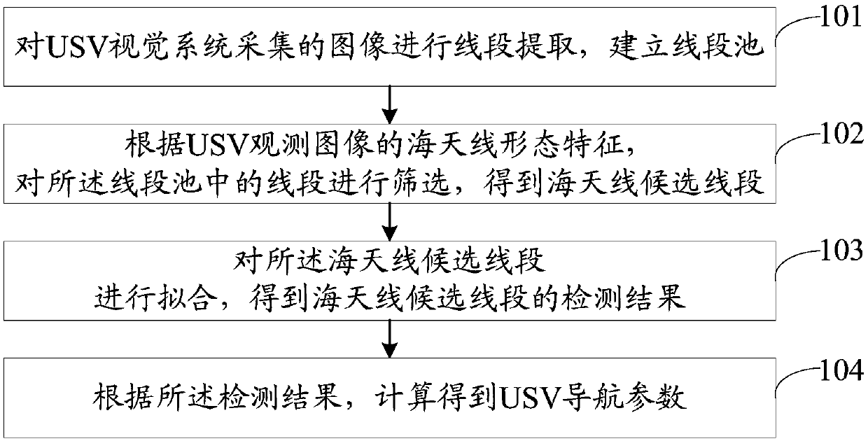
[0072] refer to figure 1 , shows a flow chart of steps of a vision-based unmanned ship sea antenna detection and navigation method in an embodiment of the present invention. In this embodiment, the vision-based unmanned marine antenna detection and navigation method includes:

[0073] Step 101, extracting line segments from images collected by the USV vision system, and establishing a line segment pool.

[0074] In this embodiment, the image collected by the USV vision system may be analyzed, all line segments in the image collected by the USV vision system may be detected, and the line segment pool may be constructed based on all the detected line segments.

[0075] Preferably, a feasible way to establish a line segment p...


PUM


Abstract

The invention discloses a method and system for sea-sky-line detection and navigation via an USV based on vision. The method comprises the following steps: extracting all the line segments in an imageby using a line segment detection algorithm, building a line segment pool, then with the morphological characteristics of a sea-sky-line as constraint conditions, filtering out non-sea-sky-line segments in the line segment pool so as to obtain candidate sea-sky-line segments; estimating optimal sea-sky-line results by using a least square method so as to obtain detection results of the candidatesea-sky-line segments; and based on the detection results of the candidate sea-sky-line segments, resolving the parameters of USV navigation on the basis of a photography model of the sea-sky-line. Thus, the method and system provided by the invention can effectively detect the sea-sky-line via the USV and accurately calculate the attitude navigation parameters of the USV.

Description

technical field [0001] The invention belongs to the technical field of marine navigation, and in particular relates to a vision-based unmanned marine antenna detection and navigation method. Background technique [0002] With the rapid development of unmanned systems and artificial intelligence technology, following drones and unmanned vehicles, unmanned surface vehicles (Unmanned Surface Vehicle, USV) are becoming more and more popular in the military and civilian fields. It plays an important role in various marine applications such as environmental monitoring, 3D mapping and enemy detection. [0003] Accurate and autonomous navigation system is one of the core technologies of USV, which is crucial to ensure that USV can complete various maritime tasks without human intervention. Usually, USV needs to be equipped with different navigation sensors, including Global Navigation Satellite System (Global Navigation Satellite System, GNSS), Inertial Navigation System (Inertial ...

Claims


Application Information

Patent Timeline
20 Apr 2018
Publication
CN107941220A
IPC
G01C21/20
CPC
G01C21/203
Inventors
胡常青; 付立