Gridding-based base station network positioning enhancement information availability monitoring method and system

A technology for enhancing information and reference stations, applied in satellite radio beacon positioning systems, radio wave measurement systems, measurement devices, etc., can solve problems reflecting the overall space availability of the reference station network system, and achieve the effect of overall space availability

Active Publication Date: 2019-10-01
JIANGSU PROVINCE SURVEYING & MAPPING ENG INST +2
View PDF5 Cites 7 Cited by
  • Summary
  • Abstract
  • Description
  • Claims
  • Application Information

AI Technical Summary

Problems solved by technology

Since it is difficult for a small number of monitoring stations to effectively cover the entire reference station network area, it is difficult to reflect the overall space availability of the reference station network system from the perspective of users

Method used


Image

  • Gridding-based base station network positioning enhancement information availability monitoring method and system
  • Gridding-based base station network positioning enhancement information availability monitoring method and system
  • Gridding-based base station network positioning enhancement information availability monitoring method and system

Examples


Embodiment Construction

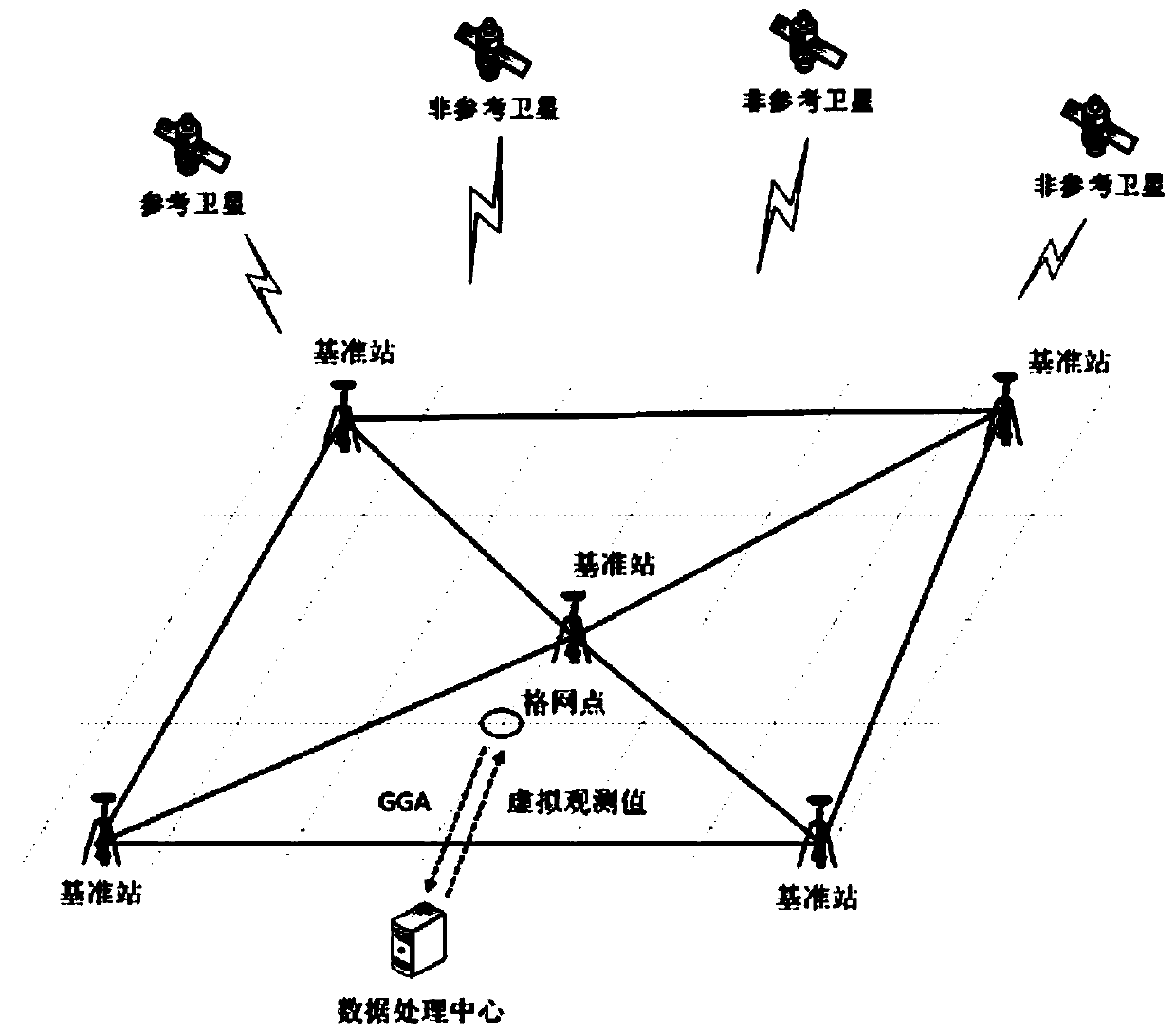
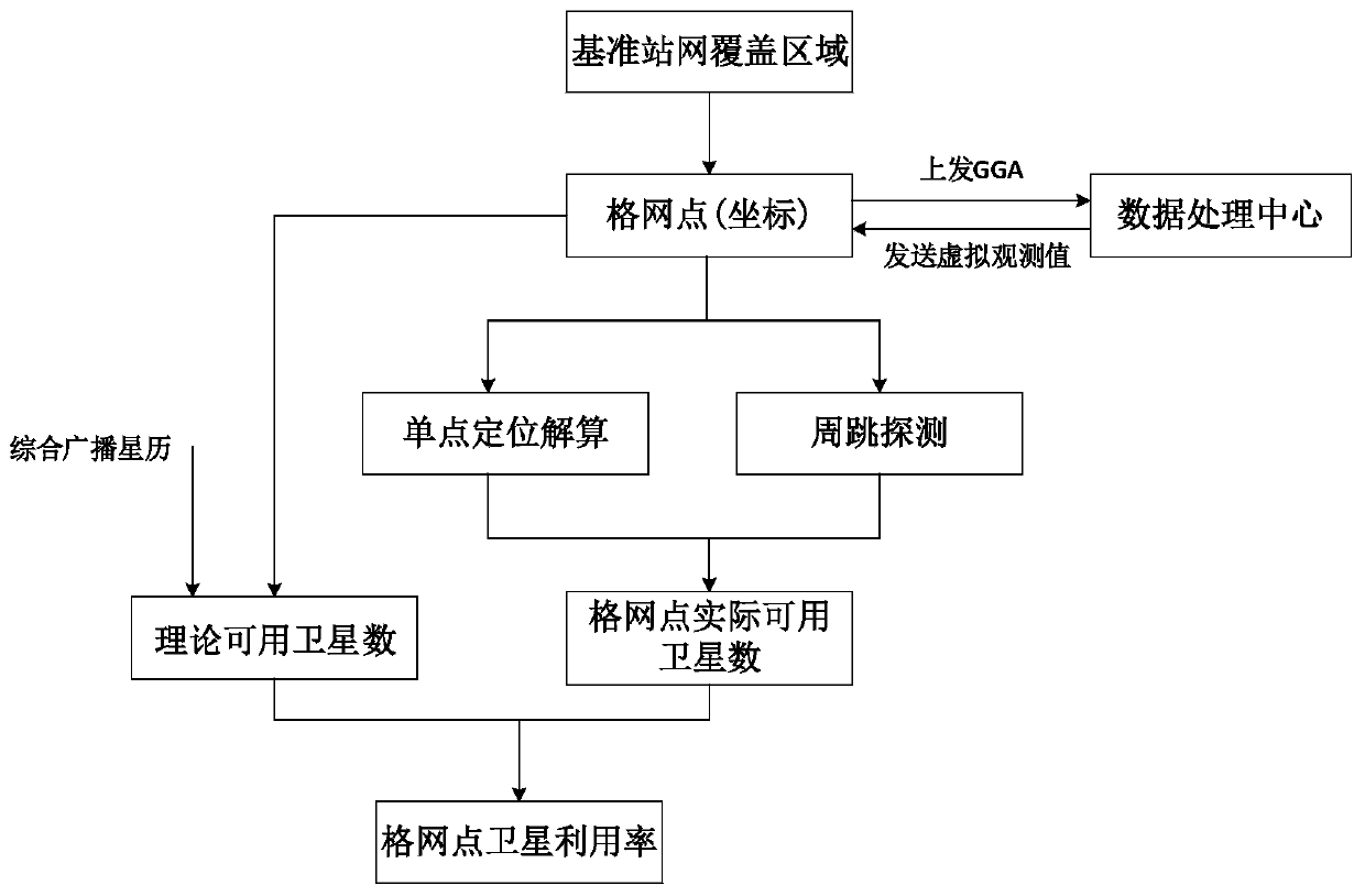
[0052] combine figure 1 with figure 2 As shown, Embodiment 1 discloses a grid-based reference station network positioning enhanced information availability monitoring method, and the specific steps are as follows:

[0053] In step (1), the known coverage area of ​​the reference station network is equally divided into grids according to latitude and longitude.

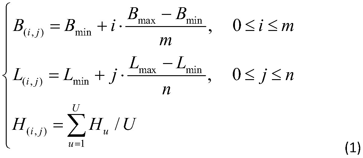
[0054] The coordinates of the divided grid points (which can be regarded as virtual reference stations) can be obtained as follows:

[0055]

[0056] In the formula, B (i,j) , L (i,j) and H (i,j) represent the latitude, longitude and height of the grid point (i, j) respectively; B max and B min Respectively represent the maximum latitude and minimum latitude of the coverage area of ​​the reference station network; L max and L min Respectively represent the maximum longitude and minimum longitude of the coverage area of ​​the reference station network; m and n represent the number of divis...


PUM


Abstract

The invention discloses a gridding-based base station network positioning enhancement information availability monitoring method. The method comprises the steps that a known region covered by a base station network is equidistantly divided into grids according to longitudes and latitudes, and three-dimensional coordinates of each grid point are obtained; according to the three-dimensional coordinates of each grid point, corresponding virtual GGA information is generated and uploaded to a data processing center to request generating a virtual observation value of each grid point; the virtual observation values returned by the data processing center are subject to cycle-slip detection and pseudo-range single-point positioning calculation, observation value anomaly detection is performed, andthe number of actual available satellites at each grid point is judged; in combination with comprehensive broadcast ephemeris of the base station network and the coordinates of the grid points, the number of theoretical available satellites at each grid point is calculated; and then the utilization rate of the satellites at each grid point in the region covered by the base station network is calculated. According to the method, uniform monitoring of positioning enhancement information in the region covered by the base station network is realized from the perspective of a user, and therefore areliable system with a high-precision positioning enhancement function is enriched and perfected.

Description

technical field [0001] The invention relates to an availability monitoring technology for enhanced positioning of a reference station network, in particular to a grid-based method for monitoring the availability of enhanced positioning information of a reference station network, and belongs to the technical field of GNSS (Global Navigation Satellite System) positioning and navigation. Background technique [0002] The GNSS continuous operation reference station network (referred to as "GNSS reference station network") is composed of a number of uniformly distributed reference stations within the region, receiving satellite navigation data in real time around the clock, and calculating inter-station atmospheric errors through inter-reference station baseline calculations Correction, and then model the positioning error for the entire coverage area. Later, using a network composed of computers, data communications and Internet technologies, it provides real-time location-enhan...

Claims


Application Information

Patent Timeline
Patent Type & Authority Applications(China)
IPC IPC(8): G01S19/20
CPCG01S19/20
Inventor 王勇潘树国高旺王开锋闫志跃乔龙雷
Owner JIANGSU PROVINCE SURVEYING & MAPPING ENG INST
Why Eureka
Try Eureka