Supercharge Your Innovation With Domain-Expert AI Agents!

Positioning precision calculation method and device based on position information

A technology of positioning accuracy and position information, used in satellite radio beacon positioning systems, measuring devices, instruments, etc.

Active Publication Date: 2020-06-02
QIANXUN SPATIAL INTELLIGENCE INC
View PDF6 Cites 2 Cited by
  • Summary
  • Abstract
  • Description
  • Claims
  • Application Information

AI Technical Summary

Problems solved by technology

[0004] The present invention provides a positioning accuracy calculation method and device based on position information, which solves the technical problem of positioning accuracy calculation for users in the industry

Method used


Image

  • Positioning precision calculation method and device based on position information
  • Positioning precision calculation method and device based on position information
  • Positioning precision calculation method and device based on position information

Examples


Embodiment 1

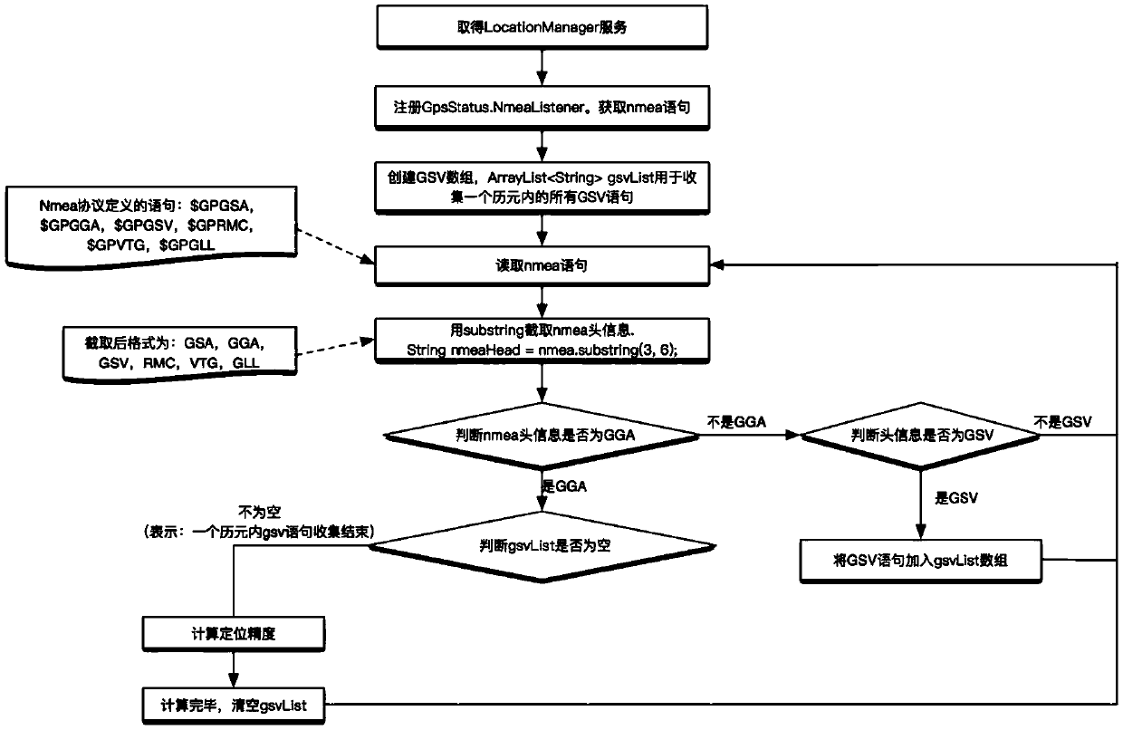
[0037] The present invention provides a positioning accuracy calculation method based on position information, such as Figure 1-2 As shown, the details are as follows:

[0038] Step 1, preset the minimum value of satellite elevation angle. Filter according to the satellite elevation angle, and exclude satellites whose satellite elevation angle is smaller than the preset value.

[0039] Execution steps of preset conditions:

[0040] Step 1.1, collect all GSV statements in an epoch, GSV (Satellites in View) refers to visible satellites, $GPGSV refers to visible satellite status output statements, for example:

[0041] $GPGSV, 2, 1, 08, 06, 33, 240, 45, 10, 36, 074, 47, 16, 21, 078, 44, 17, 36, 313, 42*78

[0042] Standard format: $GPGSV, (1), (2), (3), (4), (5), (6), (7), ... (4), (5), (6), (7) *hh(CR)(LF)

[0043] The meaning of each part is as follows:

[0044] (1) The total number of GSV sentence messages; 2;

[0045] (2) Current GSV statement number: 1;

[0046] (3)...

Embodiment 2

[0093] The present invention also provides a positioning accuracy calculation device based on position information, the device comprising:

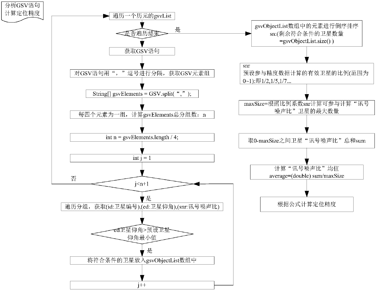
[0094] The effective satellite screening unit is used to collect all GSV sentences in an epoch, analyze all GSV sentences, exclude satellites whose satellite elevation angle is less than a preset value, and obtain the remaining effective satellite quantity;

[0095] The satellite sorting and signal-to-noise ratio calculation unit is used to preset the proportional coefficient of the effective satellites participating in the accuracy calculation, sort the effective satellites, and calculate the average value of the effective satellite signal-to-noise ratio according to the proportional coefficient;

[0096] The accuracy calculation unit is configured to calculate the positioning accuracy according to a preset accuracy calculation model.

Embodiment 3

[0098] The present invention also provides a memory, the memory stores a computer program, and the computer program performs the following steps:

[0099] Collect all GSV sentences in an epoch, analyze all GSV sentences, exclude satellites whose satellite elevation angle is smaller than the preset value, and obtain the remaining effective satellite number;

[0100] Preset the proportional coefficient of the effective satellites participating in the accuracy calculation, sort the effective satellites, and calculate the average value of the signal-to-noise ratio of the effective satellites according to the proportional coefficient;

[0101] Preset the accuracy calculation model, and calculate the positioning accuracy according to the accuracy calculation model.


PUM


Abstract

The invention provides a positioning precision calculation method and device based on position information. The method comprises the following steps of collecting all GSV statements in an epoch, analyzing all GSV statements, excluding the satellites with satellite elevation angles smaller than a preset value, and obtaining the number of the remaining effective satellites; presetting the proportionality coefficients of the effective satellites participating in precision calculation, sorting the effective satellites, and calculating an average value of the signal-to-noise ratios of the effectivesatellites according to the proportionality coefficient; presetting a precision calculation model, calculating the positioning precision according to a precision calculation model, wherein the presetprecision calculation model comprises an X-axis dimension, a Y-axis dimension and a Z-axis dimension, the X-axis is the average value of the signal-to-noise ratios, the Y-axis is the number of the effective satellites, and the Z-axis is the position point precision. According to the invention, the industrial users can conveniently obtain the precision calculation rules suitable for their devicesaccording to their daily drive tests and practice data.

Description

technical field [0001] The invention relates to the technical field of positioning accuracy calculation, in particular to a positioning accuracy calculation method and device based on position information. Background technique [0002] With the development of society, people's demand for accurate location is becoming more and more urgent. At present, satellite navigation systems developed by countries around the world have been put into use, such as GPS, GLINASS, BD, etc. The accuracy evaluation of the system is not only an important part of the overall design of the satellite navigation system, but also needs to evaluate the positioning accuracy of the system used by the user when positioning through the satellite navigation system, so as to ensure that the positioning accuracy of the satellite navigation system used can be Meet your positioning accuracy requirements. [0003] There are many methods to describe the positioning accuracy of the satellite navigation system. ...

Claims


Application Information

Patent Timeline
Patent Type & Authority Applications(China)
IPC IPC(8): G01S19/23
CPCG01S19/23
Inventor 王芳
Owner QIANXUN SPATIAL INTELLIGENCE INC
Features
  • R&D
  • Intellectual Property
  • Life Sciences
  • Materials
  • Tech Scout
  • Unparalleled Data Quality
  • Higher Quality Content
  • 60% Fewer Hallucinations
Learn More