Gnss-based map generation

a technology of automatic generation and map, applied in maps/plans/charts, navigation instruments, instruments, etc., can solve the problems of inability to apply known approaches for map generation of regular roads to construction sites or mining sites, inability to apply approaches, and inability to achieve the effect of robust and reliable map generation

Active Publication Date: 2020-10-15
SAFEMINE
View PDF0 Cites 5 Cited by
  • Summary
  • Abstract
  • Description
  • Claims
  • Application Information

AI Technical Summary

Benefits of technology

[0006]In some embodiments, the invention provides a method for an automatic generation of a road map that overcomes the special challenges of a road network of construction sites or mining sites. A method according to the invention allows for a more robust and reliable map generation.

Problems solved by technology

A special challenge in building a map for construction site roads or mining site roads is the fact that crossroads areas (junctions) are very often not rectangular in contrast to regular automobile roads.
Accordingly, known approaches for map generations of regular roads cannot be applied to construction sites or mining sites as such approaches use a junction detection based on heading change and speed change.
Other approaches take advantage of the existence of pairwise trips diverging or converging, but such approaches are also not feasible in the mine or construction context, since the roads and especially individual lanes are wider and less clearly defined compared to an urban environment.
Furthermore, the frequency of irregular driving behaviour and frequency of road network change on construction and mining sites render such approaches impractical.

Method used


Image

  • Gnss-based map generation
  • Gnss-based map generation
  • Gnss-based map generation

Examples


Embodiment Construction

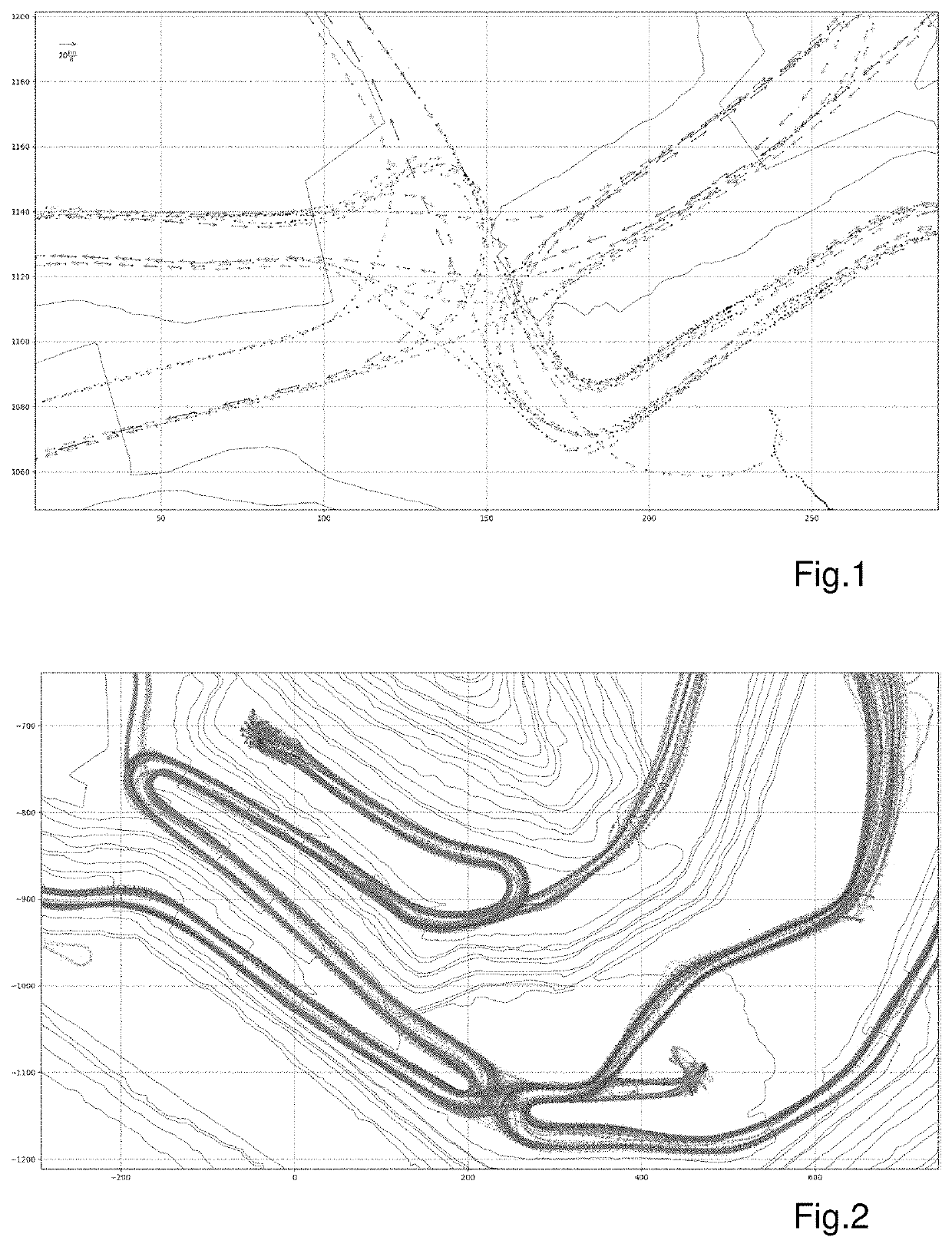
[0041]FIG. 1 shows a visualisation of a plurality of data records which are collected by GNSS-positioning systems which are equipment of vehicles. The collecting takes place while the vehicles are driving on a construction site or a mining site. Each data record comprises at least: a position information (points in FIG. 1), which indicates the position of the vehicle at the time of the data record sampling; an identification reference, by which every data record can be assigned to a specific vehicle which samples the data records; a time tag, indicative for the time at which this specific data record was sampled; a heading information (arrows in FIG. 1), which represent a current heading of the vehicle at the time of the sampling. By their lengths and opaqueness, the arrows in FIG. 1 further represent the speed information of the vehicles.

[0042]The data records can be collected on the GNSS-positioning systems and be afterwards (e.g. at the end of each day) sent to the computer for p...


PUM


Abstract

Automatic generation of a road map of a site can be performed. Data records collected by vehicles with a GNSS-positioning system while driving are provided, each data record having a position information representing a two-dimensional or three-dimensional position of the vehicle, an identification reference specific to a corresponding vehicle, a time tag, and a heading information. The data records are assigned to corresponding trips based on the time tag and the identification reference. The trips are mapped within an area and the area is divided into a plurality of uniform tiles. For each tile, a heading information variance of the data records covered by the respective tile is determined. A tile is defined as junction tile, if the tile has a heading information variance higher than a computed threshold variance. An area of interest (AoI) having a perimeter is determined by which a plurality of junction tiles is surrounded.

Description

CROSS-REFERENCE TO RELATED APPLICATIONS[0001]This application claims priority to European Patent Application No. 19168545.2 filed on Apr. 10, 2019, which is incorporated herein by reference.FIELD OF THE INVENTION[0002]The present invention relates to a method for an automatic generation of a road map of a construction site or mining site.BACKGROUND OF THE INVENTION[0003]Junctions are an essential part of road networks which is why the present method is focussed on the detection of junctions and on establishing the connections among them.[0004]A special challenge in building a map for construction site roads or mining site roads is the fact that crossroads areas (junctions) are very often not rectangular in contrast to regular automobile roads. Accordingly, known approaches for map generations of regular roads cannot be applied to construction sites or mining sites as such approaches use a junction detection based on heading change and speed change. Many junctions in construction and...

Claims


Application Information

Patent Timeline
Patent Type & Authority Applications(United States)
IPC IPC(8): G06T11/20G01S19/51
CPCG06T11/20G01S19/51G01C21/32G09B29/12G09B29/004G01C21/3841G01C21/3881
Inventor FURGER, FABIAN ISMAELHUBER, JOHANNES
Owner SAFEMINE
Why Eureka
Try Eureka