Target localization using TDOA distributed antenna

a distributed antenna and target technology, applied in direction finders, instruments, measurement devices, etc., can solve the problems of difficult to locate targets, large geometric dilution of precision (gdop), and limited response speed of associated analysis equipment, so as to achieve high direction and location finding accuracy.

Active Publication Date: 2007-01-30
SAAB INC
View PDF6 Cites 57 Cited by
  • Summary
  • Abstract
  • Description
  • Claims
  • Application Information

AI Technical Summary

Benefits of technology

[0010]It is an object of the present invention to overcome the problems of the prior art by providing a system and methods for high direction and location finding accuracy utilizing existing air traffic surveillance systems, and without requiring large individual antenna aperture, mechanical antenna rotation, or additional receivers outside the system boundaries.
[0012]The methods of the invention calculate at least an estimate of a target's position using TDOA and RTD data obtained from target transponder signals. The TDOAs are calculated by measuring the TOA of a transponder signal from the target when the signal is received at a plurality of receiver units. The receiver utilized to calculate the RTD can also function as one of the three receivers used to calculate the TDOA. Each TOA is subtracted from the TOA of a designated receiver to produce the TDOAs. Transmitting an interrogation signal from a transmitter to a target and measuring the delay time between the time of transmission of the interrogation signal and the time of arrival of the reply signal from the target at a receiver determines the RTD. The RTD data can then be used to calculate the target's precise range. By using the TDOA data in conjunction with the range provided from the RTD data, the range GDOP issues associated with the prior art multilateration technique are overcome and the range accuracies, and therefore the overall position accuracies, improve dramatically.
[0013]The method of one embodiment of the present invention calculates azimuth of a target based on TDOA data of transponder replies received by at least three antenna elements (receiving units, “RUs”), which effectively create an antenna array. When the distance of the target is much greater than the baseline, it is possible to use a simple linear approximation that computes the azimuth and elevation. If range only, or range and height are available as well, it is possible to considerably improve the measurement accuracy by performing an azimuth search at the given range and height that best matches the measured TDOA.
[0016]The search function is reiterated a specific number of times using a smaller arc each time, thereby improving the accuracy of the position estimate. If range is unavailable, then this method will compute approximate azimuth and elevation only. The azimuth that yields the smallest error from the search function is selected. Finally, the x and y positions are calculated and the height (z) is included if calculated from the altitude data.

Problems solved by technology

Typically these approach radar systems require large rotating antennas making them expensive.
In addition, these radar systems characteristically have an update rate of approximately 4.5 seconds, and consequently the response speed of the associated analysis equipment is limited by the update rate of the radar.
However, if it is required to provide large area coverage around the multilateration system, the ratio of the antenna baseline (distance between the receivers) to the range of the target becomes such that the Geometric Dilution of Precision (GDOP) becomes quite large.
It therefore becomes more difficult to locate the target within the “ellipse of uncertainty” and the effectiveness of the multilateration system is significantly degraded as the distance from the system to the target increases.
This, however, creates difficulties with regard to purchasing additional real estate, providing security outside of the system, maintenance of the external antenna elements, communication between the external antenna elements and the system, and other logistical issues.
While many air traffic surveillance systems are using one, or a combination of the above-detailed methodologies, some airports currently have no local, reliable methodologies for locating approaching aircraft, or vehicles on the ground for runway incursion.

Method used


Image

  • Target localization using TDOA distributed antenna
  • Target localization using TDOA distributed antenna
  • Target localization using TDOA distributed antenna

Examples


Embodiment Construction

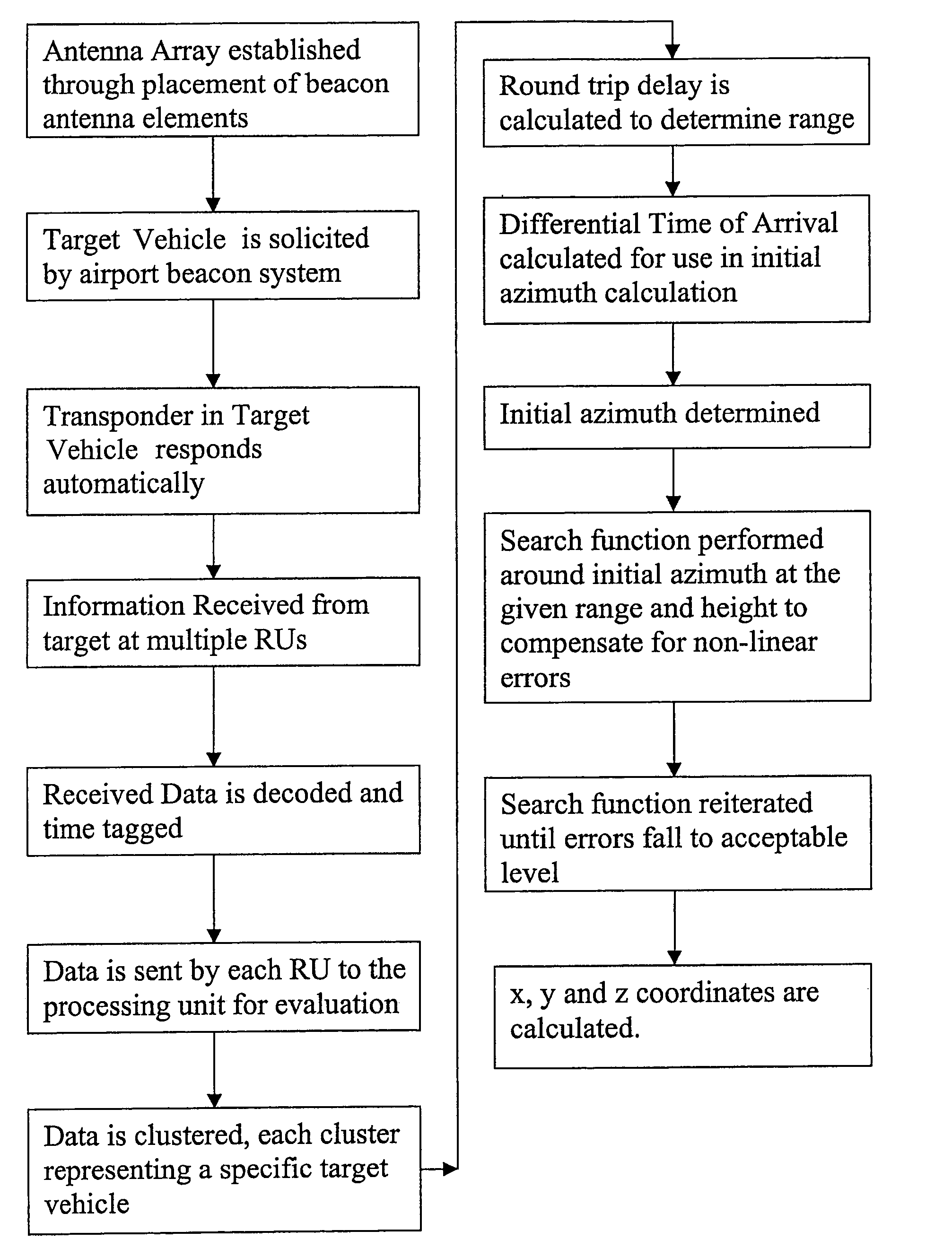
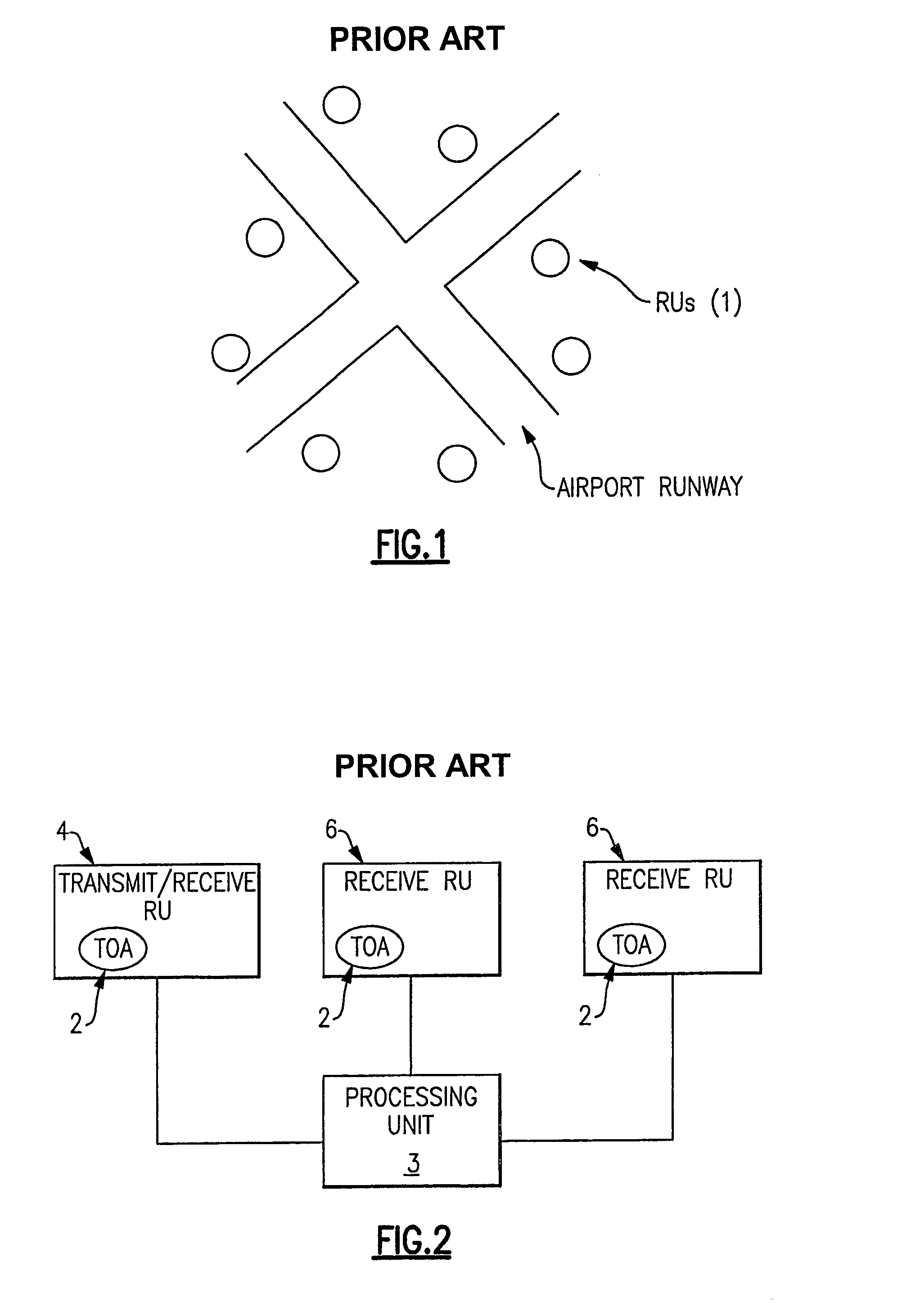
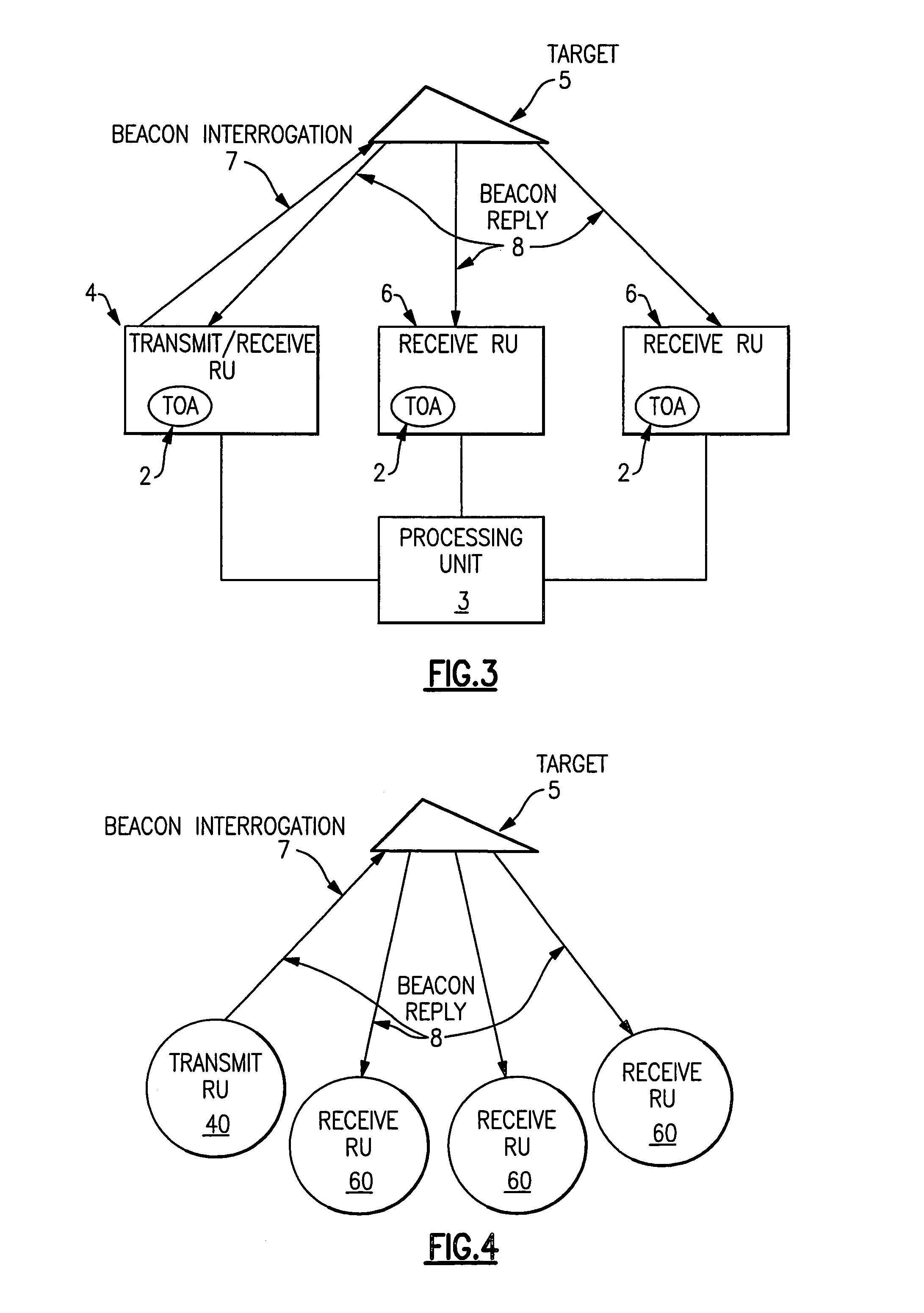
[0034]One embodiment of the present invention will now be described with reference to FIGS. 1–9. A number of antenna elements 1 (hereafter referred to as “receiving units” (RUs)) are placed in known positions within the airport confines to create an antenna array as depicted in FIG. 1. A typical RU is sold by Sensis Corporation (Model No. 100-008121-G001). The distance and placement of the RUs is referred to as the antenna array baseline or baseline. In this embodiment, any combination of at least one transmitter and three receivers is required to provide three-dimensional localization of targets in and around the airport. The RUs can receive only, transmit only, or both transmit and receive. More RUs may be required dependent upon the geography and building layout in and around the airport in order to overcome Line of Sight (LOS) obstructions and multipath issues. In accordance with the present invention, all of the RUs can be positioned within the confines of the airport, thus ins...


PUM


Abstract

This invention is a system and method of locating a target using distributed antenna. The antenna consists of several receiving elements in known locations. At least one of the receiving elements is also a transmitter and transmits an interrogation signal to a target. The return signal from the target is received by a plurality of receiving elements and the target's position is calculated using the time of arrivals of the reply signal and the round trip delay between the transmission of the interrogation signal and the reception of the subsequent reply signal.

Description

CROSS REFERENCE TO RELATED APPLICATIONS[0001]This application claims the benefit under 35 USC § 119(e) of U.S. Provisional Application Ser. No. 60 / 494,963, filed Aug. 14, 2003 and U.S. Provisional Application Ser. No. 60 / 505,997, filed Sep. 25, 2003, the entireties of which are incorporated herein by reference.FIELD OF THE INVENTION[0002]The invention relates to ground-based or airborne air traffic surveillance systems, particularly to direction finding and target localization using a TDOA (Time Differential of Arrival) distributed antenna.BACKGROUND OF THE INVENTION[0003]In the current art a number of systems and methodologies exist for the localization of ground vehicles and aircraft (e.g., targets) in and around air traffic surveillance systems which can include airports, terminal areas and en route systems.[0004]Many large airports utilize approach radar systems to locate and track targets outside the airport. These radar systems obtain good azimuth accuracy by using the narrow ...

Claims


Application Information

Patent Timeline
Patent Type & Authority Patents(United States)
IPC IPC(8): G01S13/93G01S5/02G01S5/12G01S5/14G01S13/87
CPCG01S13/878G01S5/12
Inventor PERL, ELYAHUGERRY, MICHAEL J
Owner SAAB INC
Why Eureka
Try Eureka