Method for establishing panorama electronic map service

An electronic map and panorama technology, applied in the field of building panoramic electronic map services, can solve problems such as heavy workload, lack of operability, and inability to meet user search needs, and achieve the effect of accurate judgment and decision-making

Active Publication Date: 2009-05-20
BEIJING BAIDU NETCOM SCI & TECH CO LTD
View PDF4 Cites 2 Cited by
  • Summary
  • Abstract
  • Description
  • Claims
  • Application Information

AI Technical Summary

Problems solved by technology

In the existing electronic map services, some map service providers have introduced panoramas into map search services, such as the panorama map of mapabc. However, it is difficult to adapt to the above-mentioned panoramas in the existing electronic map services. User needs, such as mapabc's panorama map, users can see the location points and text links with panoramic images on the map by entering the homepage of the panorama map, and can watch the panorama by clicking, but because the number of its collection is quite small, for For the vast majority of search users, they cannot see the panoramic image of the point of interest. This kind of panoramic display is passive rather than active. The panorama of the location (that is, active display), but the user finds a place with a panoramic view on the panoramic map, and then watches it (that is, passive display)
At the same time, the above-mentioned panoramas do not have location information, so it is necessary to associate the panoramas with address names or calibrate on the electronic map to locate the panoramas on the electronic map. When the number of panoramas reaches a certain level, this method has a huge workload and low efficiency. It is not operable, and at the same time, some collection points do not have common names. For example, 25 panoramas were collected along a 500-meter-long green space. There is neither a house number nor a landmark building. If you want to pass the address Name association requires setting a name on the electronic map, and at the same time setting the corresponding name for the panorama, and associating them. However, users do not know these names when searching, and their search experience will be quite poor. This is a common problem. Happening
If the association is made by marking on the electronic map, since the streets with scales on the electronic map have a weak sense of location, it is difficult for users to accurately locate the collected panoramic images on the electronic map through naked eye observation, which will also seriously affect User experience. In addition, in the existing mode, there is no overlapping area between the panoramas, and the user cannot see the information near the panorama when viewing, so the information obtained by the user is not continuous. In terms of retrieval, the user usually Enter a location name, in the existing mode, the electronic map can only display panoramic images with the same or similar name rules, but cannot display panoramic images of any street location
In fact, the existing model cannot bring substantial help to people's daily life reference. Collecting panoramic images of some scenic spots in a city and allowing users to find the information they care about in these panoramic images is far from being achieved. The user's search needs, and a mode where the user can see where they search will bring substantial help to the user's daily life experience

Method used


Image

  • Method for establishing panorama electronic map service
  • Method for establishing panorama electronic map service
  • Method for establishing panorama electronic map service

Examples


Embodiment Construction

[0017] specific implementation plan

[0018] In order to make the technical means, creative features, goals and effects achieved by the present invention easy to understand, the present invention will be further described below in conjunction with specific embodiments.

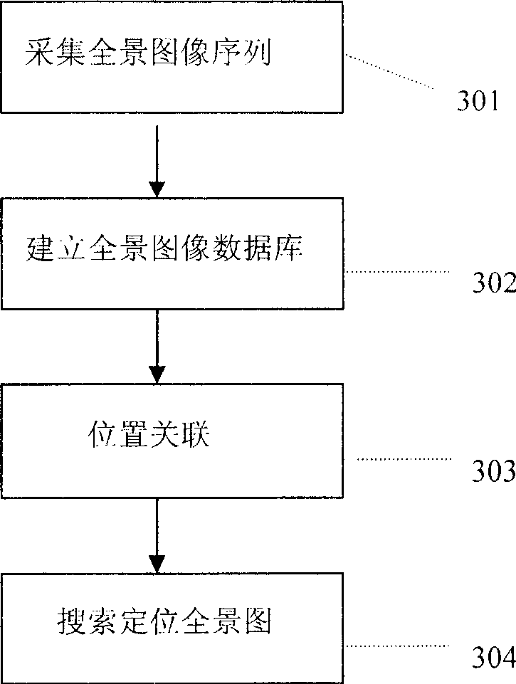
[0019] The invention proposes a method for constructing a panoramic electronic map service, the purpose of which is to provide more detailed, detailed and vivid map services to existing electronic map users.

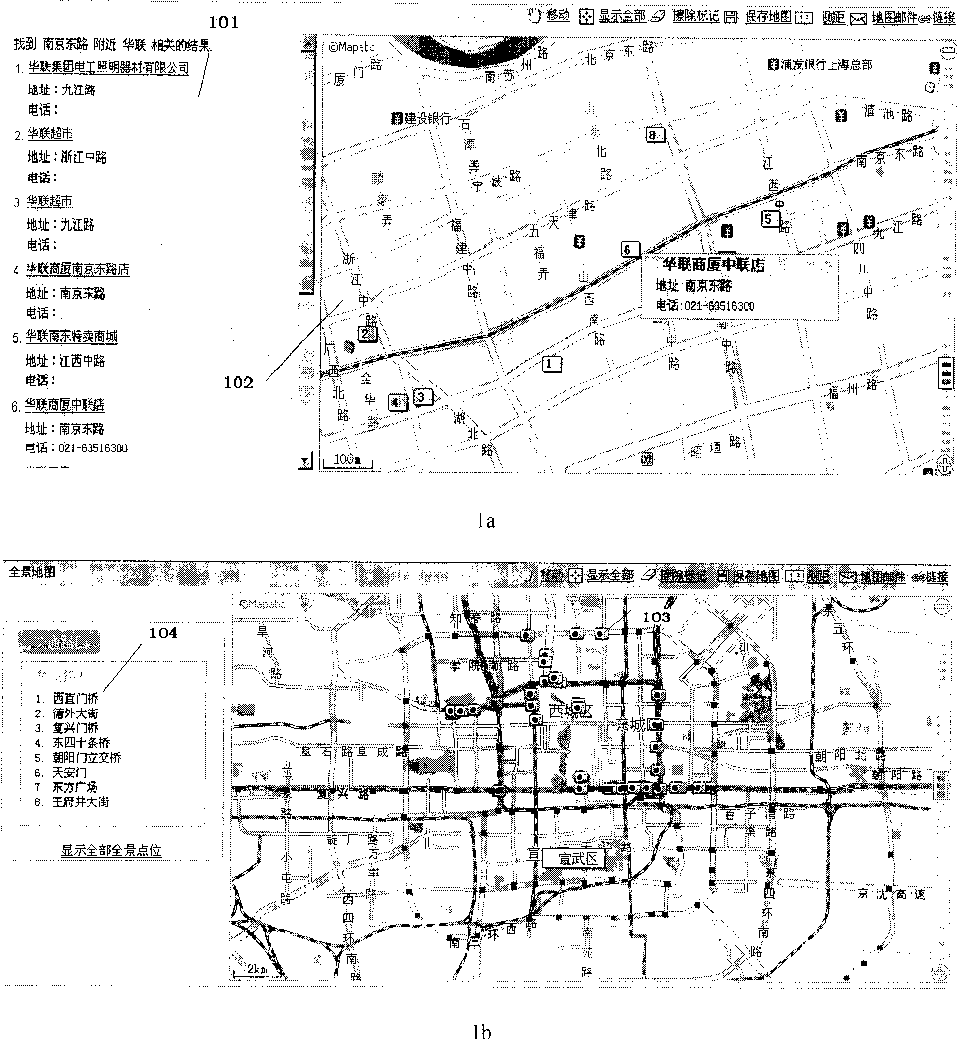
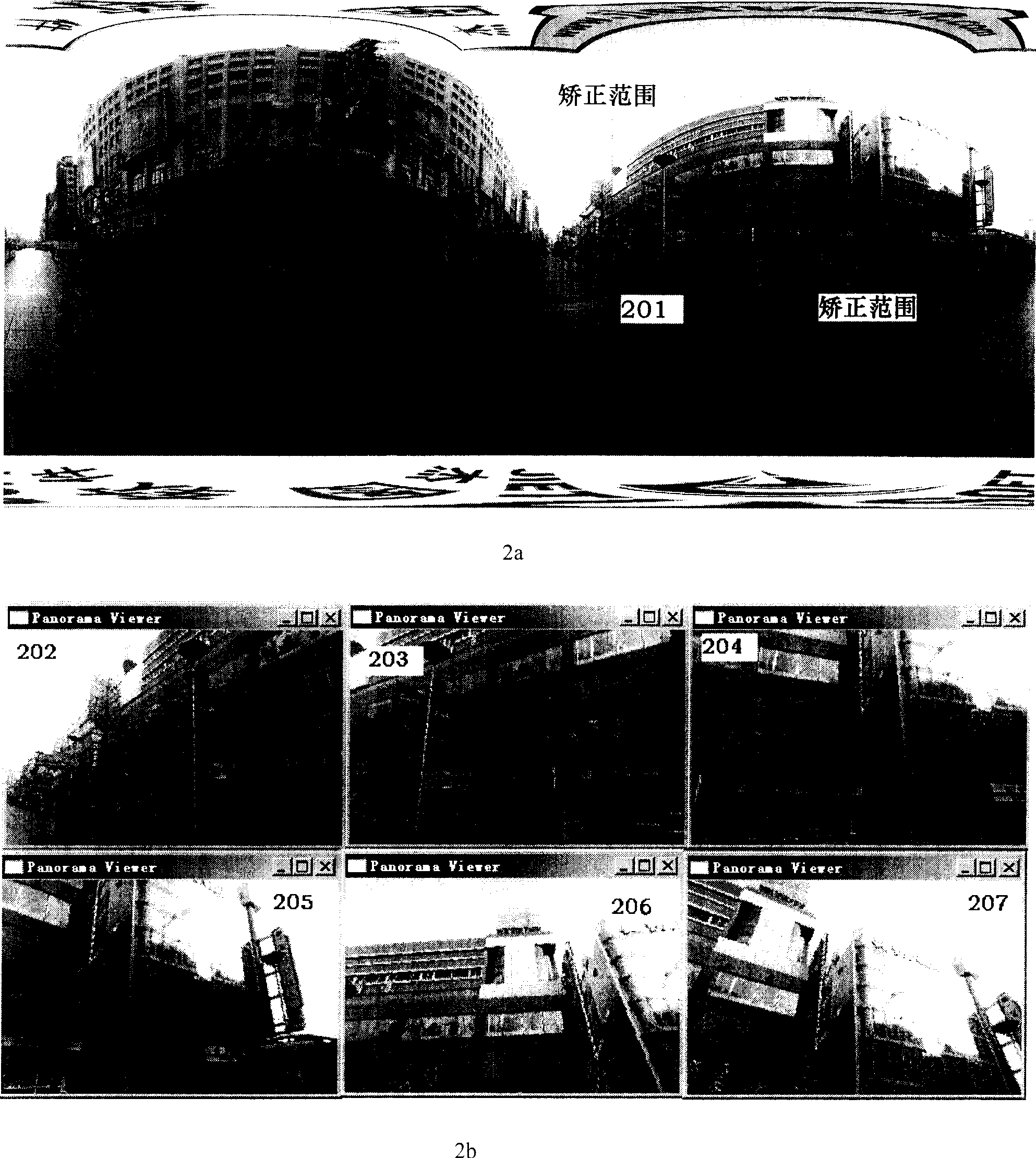
[0020] figure 1 A case of existing electronic map service and mapabc panorama electronic map representation mode are given, in which 1a is a schematic diagram of an electronic map service case. This picture takes mapabc as an example, the search area is Nanjing East Road, Shanghai, and the search term is the screenshot of the search results of Hualian. Among them, area 101 is the textual expression result of the search, and area 102 is the position of these search results in the electronic map. Among t...


PUM


Abstract

The invention relates to a method for building panorama electric map serve, which comprises: (1), collecting panorama graph sequence, as collecting the panorama graph sequence with geography continuous information; (2) building a database containing said panorama graph sequence in the server; (3), building relationship interlinkage of positions, that interlinking the panorama graph sequence of database with the electric map via the position information; (4), searching and positioning the panorama graph that when the user searches, via search word, positioning the user needed point on the electric map, and via the geography position information (gis) of said point to find the position information of panorama graph sequence; transferring the panorama graph. With said invention, present electric map can support detailed map server, and via the panorama display function, user can attain the detail information.

Description

technical field [0001] The invention relates to a method for constructing an electronic map service, in particular to a method for constructing a panoramic electronic map service. Through this method, the inquirer can clearly understand the 360° panorama information of the inquired place. Background technique [0002] In the past one or two years, electronic maps, especially map search services, have become a popular search service recently. Traditional search service giants such as google, msn, yahoo, sina, and baidu have all launched their own electronic map search services. The search service can conveniently solve life problems such as people's travel reference, and provides users with a convenient, flexible and efficient map search service. Through this service, the user can know the position of the concerned location on the map, for example, the user wants to know where the Shanghai Pudong Software Park is located in Shanghai. By searching for facilities near specifi...

Claims


Application Information

Patent Timeline
Patent Type & Authority Patents(China)
IPC IPC(8): G06F17/30G09B29/00
Inventor 刘小华
Owner BEIJING BAIDU NETCOM SCI & TECH CO LTD
Why Eureka
Try Eureka