Track display method and system and map server

A technology of a map server and a display method, which is applied in the field of communication, and can solve the problems of inaccurately displaying carrier trajectories and messy carrier trajectories, etc.

Active Publication Date: 2011-07-20
HUAWEI TECH CO LTD
View PDF6 Cites 53 Cited by
  • Summary
  • Abstract
  • Description
  • Claims
  • Application Information

AI Technical Summary

Problems solved by technology

[0004] In the prior art, when the trajectory is displayed on the map, the trajectory is directly drawn on the map by dotted lines, but this method may cause the displayed trajectory of the carrier to be very messy and cannot accurately display the trajectory of the carrier

Method used


Image

  • Track display method and system and map server
  • Track display method and system and map server
  • Track display method and system and map server

Examples


Embodiment Construction

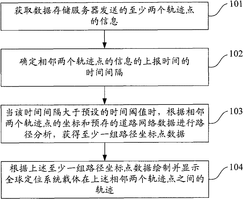
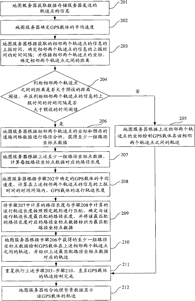
[0025] In order to make the purpose, technical solutions and advantages of the embodiments of the present invention clearer, the technical solutions in the embodiments of the present invention will be clearly and completely described below in conjunction with the drawings in the embodiments of the present invention. Obviously, the described embodiments It is a part of embodiments of the present invention, but not all embodiments. Based on the embodiments of the present invention, all other embodiments obtained by persons of ordinary skill in the art without making creative efforts belong to the protection scope of the present invention.

[0026] The success of GPS positioning has a lot to do with the quality of the signal. In practical applications, GPS often fails to locate due to the influence of objective conditions, so that the coordinates of the track points cannot be reported. Therefore, when combined with the GIS map system, the display When the GPS carrier track is mis...


PUM


Abstract

The embodiment of the invention provides a track display method, a track display system and a map server. The track display method comprises: receiving information of at least two track points from a data storage server, wherein the information of the track points comprises the coordinates of the track points and the reporting times of the information of the track points, and the information of the at least two track points is arranged according to the reporting times of the information of the at least two track points; determining the time interval of the reporting times of the information of two adjacent track points; when the time interval is greater than a preset time threshold, performing path analysis according to the coordinates of the two adjacent track points and prestored path network data, so as to acquire at least one group of path coordinate point data; and drawing and displaying the track of a global positioning system (GPS) carrier between two adjacent track points according to the at least one group of path coordinate point data. In the embodiment of the invention, when the GPS fails to report track points normally, the track of the GPS carrier in the part of which the reported track points are missed can be drawn and displayed to display accurate track condition of the GPS carrier.

Description

technical field [0001] The embodiments of the present invention relate to the field of communication technologies, and in particular, to a track display method, system and map server. Background technique [0002] Global Positioning System (Global Positioning System; hereinafter referred to as: GPS) is a global, all-weather and continuous satellite radio navigation system that can provide real-time three-dimensional coordinates, three-dimensional speed and high-precision time information. Because GPS has the advantages of high positioning accuracy, fast speed and wide range, the application of GPS is very extensive, covering almost all fields of the national economy. [0003] According to the characteristics of GPS, solutions such as positioning supervision based on GPS and Geographic Information System (GIS for short) are widely used. The positioning supervision solution is to install GPS receivers on various carriers that need to be supervised, such as personnel or vehicl...

Claims


Application Information

Patent Timeline
Patent Type & Authority Applications(China)
IPC IPC(8): G01C21/22
Inventor 邓维军
Owner HUAWEI TECH CO LTD
Why Eureka
Try Eureka