Method for determining deep rock structural surface attitude by utilizing television image of single vertical drilling hole

A TV image and structural surface technology, applied in optical exploration and other directions, can solve the problems of high cost of deep drilling, unsuitable fractured structural surface, and high cost of three drilling holes

Inactive Publication Date: 2012-04-18
CHONGQING UNIV
View PDF5 Cites 9 Cited by
  • Summary
  • Abstract
  • Description
  • Claims
  • Application Information

AI Technical Summary

Problems solved by technology

This method has three disadvantages: the identification of the same structural plane revealed by different drill holes is easy to be misjudged; three drill holes may not reveal some small-scale structural planes at the same time; Drilling costs are too high
There are also high-tech methods such as high-density electrical method and EH4 electromagnetic detection and imaging system to measure the occurrence of relatively large-scale ore veins or faults in the deep, but these methods are only suitable for large-scale geological structural planes, and for small-scale fractures Sexual structure is not suitable

Method used


Image

  • Method for determining deep rock structural surface attitude by utilizing television image of single vertical drilling hole
  • Method for determining deep rock structural surface attitude by utilizing television image of single vertical drilling hole
  • Method for determining deep rock structural surface attitude by utilizing television image of single vertical drilling hole

Examples


example 1

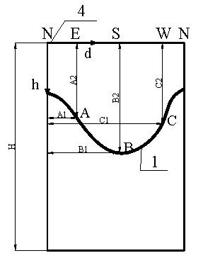
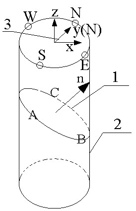
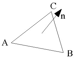
[0042] According to the actual situation of on-site drilling; the drilling depth is 12m, and the hole diameter is 130mm. The drilling TV image is processed (such as Figure 5 shown), read the position coordinates (unit: m) of three points that are not collinear in the structural surface in the image: A 1 (0, -4.25), B 1 (0.21, -4.35), C 1 (0.3266,-4.3); Carry out coordinate transformation and substitute formula (1) to get the space Cartesian coordinates: A 1 (0, 0.065, -4.25), B 1 (-0.0058, -0.0647, -4.35), C 1 (-0.0619, 0.02, -4.3); Substituting the normal vector formula (2) to obtain the normal vector of the structural surface is n (0.001985, 0.00648, -0.0083); substituting the human formula (3) to calculate the inclination angle to be 39.3°; intercept the plane N(n 1 , n 2 ) is: N(-19.85, -64.8), located in the third quadrant; the inclination obtained by substituting formula (4) is 197°; then the occurrence of the structural plane is determined to be 197°∠39.3°.

example 2

[0044] According to the actual situation of drilling on site, extract the vertical drilling depth of 12m, the hole diameter is 130mm drilling TV image for processing (such as Image 6shown), read the position coordinates (unit: m) of three points in the image that are not collinear on the structural surface: A 2 (0, -10.7), B 2 (0.16, -10.55), C 2 (0.3266,-10.65); Carry out coordinate conversion and substitute formula (1) to get the space Cartesian coordinates: A 2 (0, 0.065, -10.7), B 2 (0.0408, -0.0505, -10.55), C 2 (-0.0619, 0.02, -10.65); the formula (2) for the normal vector of the structural surface is: n(0.000975, -0.011325, -0.008985); the inclination angle obtained by the formula (3) is 51.68°; Obtain N(n by intercepting the plane projection 1 , n 2 ) is: N(-9.75, 113.25), located in the fourth quadrant; the inclination obtained by substituting formula (4) is 315°; then the occurrence of the two structural planes is determined to be 315°∠51.68°.

[0045] The st...


PUM


Abstract

The invention relates to a method for determining a deep rock structural surface attitude by utilizing a television image of a single vertical drilling hole. The method comprises the following sequential steps of: 1. marking a geographic orientation point on a drilling hole and carrying out drilling television and image extraction; 2. marking a corresponding geographic orientation point on a television spreading image and establishing a two-dimensional coordinate system; 3. marking the rock structural surface to be determined on attitude, on the image, selecting three non-collinear points from the structural surface and measuring plane coordinate values of the three non-collinear points; 4. coiling the image into a cylinder according to the drilling hole shape, vertically arranging the cylindrical image and establishing a three-dimensional rectangular coordinate system; and 5. calculating a vector of a structural surface normal by applying a space vector geometric theory and calculating the attitude of the structural surface. The method is favorable for overcoming the defects of high cost for determining the deep structural surface by three drilling holes, large same structural surface identification errors and poor precision of other geophysical prospecting methods relative to a small-scale structural surface, and the like, can be used for fully utilizing the structural surface information of the single drilling hole and is adapted to the statistic analysis of various structural surface attitudes.

Description

technical field [0001] The invention relates to a method suitable for measuring and counting the occurrence of structural planes in deep rock mass. Background technique [0002] The "deep part" mentioned in the present invention refers to a certain depth below the surface or within the excavation surface, that is, a deep rock mass that is inconvenient to construct or cannot be reached by conventional exploration measures (such as caves and trenches, etc.), but drilling An underground rock mass that is fully accessible by technology. At present, the measurement of the occurrence of structural planes in deep rock mass is mainly based on the spatial position of the same structural plane exposed by three adjacent boreholes and calculated through spatial geometry theory. This method has three disadvantages: the identification of the same structural plane revealed by different drill holes is easy to be misjudged; three drill holes may not reveal some small-scale structural planes...

Claims


Application Information

Patent Timeline
Patent Type & Authority Applications(China)
IPC IPC(8): G01V8/02
Inventor 黄达张永兴金华辉杨海清
Owner CHONGQING UNIV
Why Eureka
Try Eureka