Map splicing display method based on plurality of display terminals
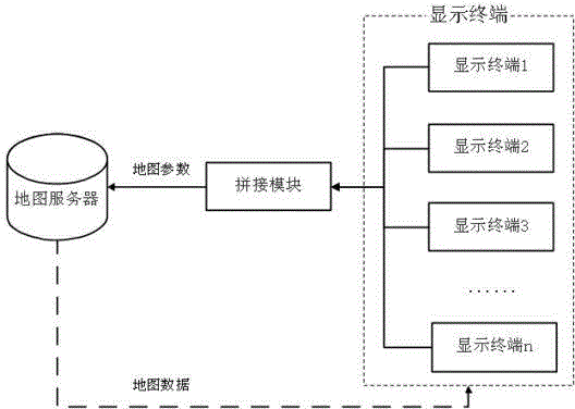
A display terminal and splicing display technology, applied in the field of geographic information, can solve the problems of slow display speed, unable to meet real-time browsing, unable to process map operation instructions synchronously splicing display, etc., to achieve the effect of expanding the display size
- Summary
- Abstract
- Description
- Claims
- Application Information
AI Technical Summary
Problems solved by technology
Method used
Image
Examples
Embodiment
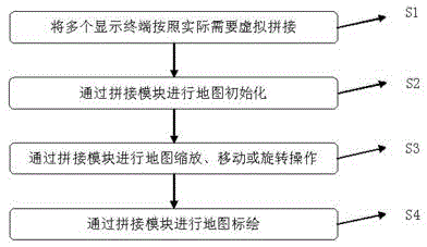
[0037] Such as Figure 5As shown, in the embodiment of the present invention, the tablet computer 1 and the mobile phone 2 are used as display terminals to perform screen virtual splicing display. Tablet PC 1 and mobile phone 2 are 7 inches and 5 inches in size respectively: Tablet PC 1 is 20 cm long and 12 cm wide, and display screen 4 is 16 cm long and 8 cm wide except frame 3; cell phone 2 is 14 cm long and 8 cm wide, except frame 6 Display screen 5 is long 12cm, wide 6cm. The splicing method is as figure 2 shown.
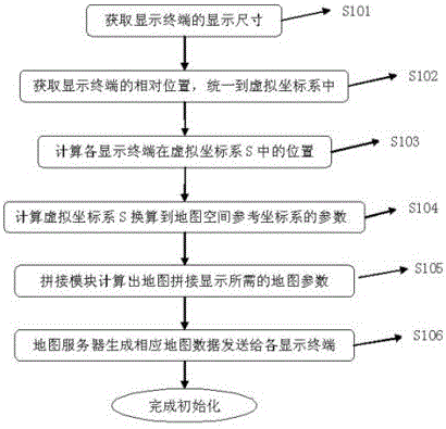
[0038] The steps to implement map mosaic display by these two display terminals are as follows:
[0039] S301: Place the tablet computer 1 and the mobile phone 2 at corresponding physical locations according to actual needs, such as Figure 5 shown;
[0040] S302: Taking the tablet computer 1 as a benchmark reference, establish a virtual coordinate system, set the horizontal direction of the tablet computer 1 as the X axis, set the vertical direction of th...
PUM
 Abstract
Description
Claims
Application Information
 - R&D
- Intellectual Property
- Life Sciences
- Materials
- Tech Scout
- Unparalleled Data Quality
- Higher Quality Content
- 60% Fewer Hallucinations
Browse by: Latest US Patents, China's latest patents, Technical Efficacy Thesaurus, Application Domain, Technology Topic, Popular Technical Reports.
© 2025 PatSnap. All rights reserved.Legal|Privacy policy|Modern Slavery Act Transparency Statement|Sitemap|About US| Contact US: help@patsnap.com


