Underground coal mine unidimensional positioning method and system based on wireless sensor network

A wireless sensor and positioning method technology, applied in transmission systems, location-based services, network topology, etc., can solve the problems of complex structure, high power consumption, and high cost

Active Publication Date: 2012-10-03
CHINA UNIV OF MINING & TECH (BEIJING)
View PDF5 Cites 25 Cited by
  • Summary
  • Abstract
  • Description
  • Claims
  • Application Information

AI Technical Summary

Problems solved by technology

[0008] In order to overcome the above deficiencies, especially to overcome the mine positioning system’s low positioning accuracy, high cost, the positioning effect is easily affected by the environment, the number and deployment density of reference nodes in the roadway are limited, the volume of mine equipment is limited, the structure is complex, and the power consumption Advanced problem, the present invention provides a kind of wireless sensor network-based underground coal mine one-dimensional positioning method and system

Method used


Image

  • Underground coal mine unidimensional positioning method and system based on wireless sensor network
  • Underground coal mine unidimensional positioning method and system based on wireless sensor network
  • Underground coal mine unidimensional positioning method and system based on wireless sensor network

Examples


Embodiment Construction

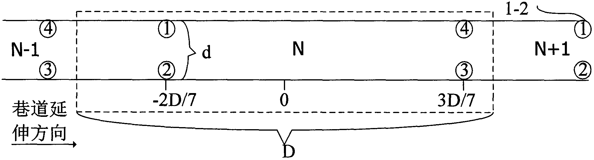
[0064] The present invention will be further described in detail below in conjunction with the accompanying drawings and specific embodiments, but the following description is only illustrative, and the protection scope of the present invention is not limited by the following description. The present invention realizes one-dimensional positioning. The reference node coordinate X of each intrinsically safe reference node in the database refers to its distance from the entrance of the roadway. A small node coordinate indicates that it is close to the entrance of the roadway, and a large node coordinate indicates that it is far away from the roadway. Mouth far.

[0065] 1. figure 1 is an intrinsically safe reference node deployment diagram of the present invention. Such as figure 1 As shown, the roadway is divided into a plurality of continuous non-overlapping rectangular intervals with equal long sides from the entrance of the roadway, and each interval is a rectangular positi...


PUM


Abstract

The invention provides an underground coal mine unidimensional positioning method and system based on a wireless sensor network. According to the undimensional positioning method, a roadway is divided into a plurality of continuous non-overlapping rectangular positioning units with equal long sides, and deployment reference nodes are non-symmetrically arranged so as to record information of each rectangular positioning unit; each reference node utilizes periodic broadcasting signals of other adjacent reference nodes to update a corresponding parameter in a reference node data packet; a mobile node is used for filtering and sequencing the reference node data packet, and recording the IDs (Identifications) of adjacent mobile nodes; and the mobile nodes are positioned through calculation, sequencing and size comparison of the reference node data packet, the recorded IDs of the adjacent mobile nodes and the database information. The underground coal mine unidimensional positioning system comprises a plurality of wireless sensor sub-networks deployed in the roadway, a central switch arranged on the ground, and a safety monitoring and information management network. The underground coal mine unidimensional positioning method and system based on the wireless sensor network, provided by the invention, have the advantages of high positioning accuracy, low cost, simple system structure and low power consumption, and can meet the specific requirements of operating environment and security of the underground mine coal.

Description

technical field [0001] The present invention relates to a positioning method and system, in particular to a one-dimensional positioning method and system based on a wireless sensor network (Wireless sensor network) in a coal mine. Background technique [0002] Coal is the main energy in our country, accounting for about 70% of primary energy, and more than 95% of coal mines in our country are mined manually. Due to complex geological conditions, low level of mining science and technology, poor management and other reasons, my country's coal mine safety accidents occur frequently, causing life, property and social impacts that are incalculable, seriously restricting the healthy development of my country's coal industry, so it is necessary It is of great significance to study the personnel positioning system suitable for underground mines to improve production efficiency, ensure the safety of underground personnel, and timely rescue after disasters. [0003] Underground coal m...

Claims


Application Information

Patent Timeline
Patent Type & Authority Applications(China)
IPC IPC(8): H04W4/02H04W4/06H04W64/00H04W84/18H04B17/00E21F17/18
CPCY02B60/50Y02D30/70
Inventor 孙继平刘志勇陈文超
Owner CHINA UNIV OF MINING & TECH (BEIJING)
Why Eureka
Try Eureka