A method and device for classifying flood risk levels

A technology of risk level and flood disaster, applied in the field of level, can solve the problems that are not considered, the technical applicability is not strong, and the data requirements are high, so as to achieve the effect of increasing the frequency of monitoring

Inactive Publication Date: 2017-10-27
MIN OF CIVIL AFFAIRS NAT DISASTER REDUCTION CENT
View PDF2 Cites 0 Cited by
  • Summary
  • Abstract
  • Description
  • Claims
  • Application Information

AI Technical Summary

Problems solved by technology

The flood risk index calculated by this method has a strong physical meaning, but the disadvantage is that it requires high data
[0026] At present, the defects of the regional flood disaster risk assessment technology mainly include: 1) The differences in the disaster mechanism of flood disasters on different spatial scales are not considered, which leads to the poor applicability of the technology; 2) In the risk assessment model In the design process of the model, the availability of model input data was not considered, resulting in a low degree of commercialization of the technology

Method used


Image

  • A method and device for classifying flood risk levels
  • A method and device for classifying flood risk levels
  • A method and device for classifying flood risk levels

Examples


Embodiment 1

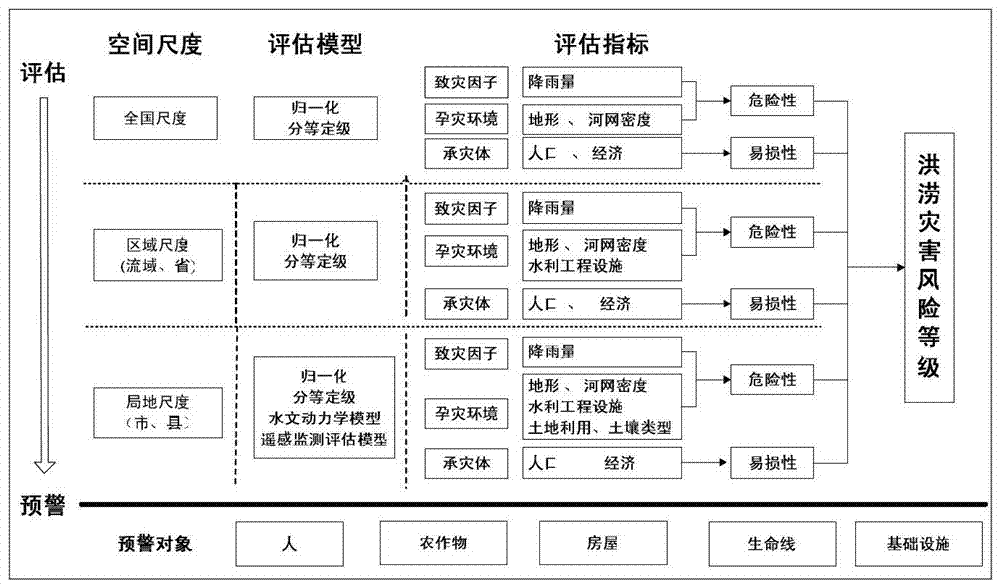
[0094] According to the analysis of the flood risk assessment model, combined with the existing basic geographic data, meteorological data and the results provided by upstream products, considering the availability of data, in the flood risk assessment of each level, the rainfall data, terrain data, river and lake data were selected. Factors such as distribution data, land use type, soil type, vegetation coverage, and water conservancy facilities are used as risk evaluation indicators, and statistical data such as population and economy are used as vulnerability indicators, and are determined by expert scoring method and analytic hierarchy process. The weight of each evaluation index is used to determine the risk level of flood disaster, and on this basis, the risk level of flood disaster is divided.

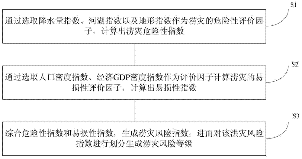
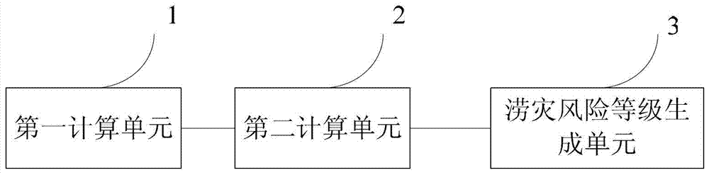
[0095] The invention provides a method for classifying flood risk levels, such as figure 1 As shown, the method includes:

[0096] S1. Calculate the flood risk index by selecti...

Embodiment 2

[0146] This embodiment provides a national flood risk assessment method based on grading and grading, which specifically includes the following aspects:

[0147] 1) Design ideas

[0148] The model selects rainfall index, terrain index and water network density index as evaluation factors to calculate the risk evaluation factors of national flood disasters through the method of grading and grading, and calculates the nationwide flood disaster risk index; through Select the population density index and the economic GDP index as the evaluation factors to calculate the vulnerability evaluation factors of flood disasters, and calculate the nationwide vulnerability index; then integrate the risk index and vulnerability index to generate the nationwide flood disaster Risk index, and then divided to generate flood disaster risk level.

[0149] 2) Index selection

[0150] According to the previous analysis of flood risk and vulnerability, combined with the needs of large-scale nation...

Embodiment 3

[0180]This embodiment has described the regional (river basin / province) flood risk assessment method based on grading and grading, which is specifically divided into the following aspects:

[0181] 1) Design ideas

[0182] The model selects rainfall index, terrain index, water network density index, and hydraulic engineering index as evaluation factors to calculate the risk evaluation factors of floods within the area (watershed, province) through the method of grading and grading, and calculates the flood risk Risk index; By selecting population density index and economic GDP index as evaluation factors to calculate the vulnerability evaluation factor of flood disaster, calculate the vulnerability index within the scope of the region (watershed, province); and then integrate the risk index and vulnerability Index, generate the flood risk index within the region (river basin, province), and then divide and generate the flood risk level.

[0183] 2) Index system

[0184] Acco...


PUM


Abstract

The present invention provides a method for dividing flood risk levels according to multiple spatial scales. At each spatial scale, the method includes: S1. By selecting precipitation index, river and lake index, and terrain index as the risk assessment factors for waterlogging , to calculate the waterlogging risk index; S2. By selecting the population density index and the economic GDP density index as the evaluation factors to calculate the vulnerability evaluation factor of the waterlogging disaster, and calculate the vulnerability index; S3. The comprehensive risk index and the vulnerability index , to generate a waterlogging risk index, and then divide the flood risk index to generate a waterlogging risk level. The above method is carried out in the order from large spatial scale to small spatial scale. The method for classifying flood risk levels provided by the present invention realizes the analysis of areas and risk levels that may cause social and economic damage due to flood disaster phenomena on different time and space scales, and increases the monitoring frequency of high-risk areas.

Description

technical field [0001] The invention relates to the technical field of flood disaster risk control, in particular to a method and device for classifying flood risk levels. Background technique [0002] Flood is a hydrological phenomenon with a large peak height and a sharp rise in river water level. It is the product of changes in the natural environment system, and its occurrence and development are affected and restricted by the natural environment system. Floods bring disasters to human beings and form flood disasters. [0003] Flood Disaster mainly refers to the flood caused by the abnormal and irregular movement of atmospheric precipitation, which brings losses and disasters to the normal life and production of human beings. From the perspective of disaster science, flood and flood disasters are disaster-causing factors—floods, in a certain disaster-forming environment, act on the disaster situation formed by the disaster-bearing body. The generation of flood and flood...

Claims


Application Information

Patent Timeline
Patent Type & Authority Patents(China)
IPC IPC(8): G06F19/00
Inventor 杨思全聂娟范一大胡卓玮崔燕和海霞王平
Owner MIN OF CIVIL AFFAIRS NAT DISASTER REDUCTION CENT
Why Eureka
Try Eureka