Adaptive Classification Method for Multispectral Remote Sensing Images Based on Spectral Labeling

An adaptive classification and remote sensing image technology, applied in the field of image processing, can solve the problems of poor applicability of training data, difficulty in realizing automatic classification, slow execution speed, etc., achieve fast classification speed, enhance versatility, and avoid manual operation.

Active Publication Date: 2017-02-15
XIDIAN UNIV
View PDF4 Cites 0 Cited by
  • Summary
  • Abstract
  • Description
  • Claims
  • Application Information

AI Technical Summary

Problems solved by technology

[0008] In summary, the existing multispectral remote sensing image classification methods have the disadvantages of low classification accuracy, slow execution speed, and poor universal applicability of training data. At the same time, the above classification methods need to manually set the number of classifications, making it difficult to achieve automatic classification.

Method used


Image

  • Adaptive Classification Method for Multispectral Remote Sensing Images Based on Spectral Labeling
  • Adaptive Classification Method for Multispectral Remote Sensing Images Based on Spectral Labeling
  • Adaptive Classification Method for Multispectral Remote Sensing Images Based on Spectral Labeling

Examples


Embodiment Construction

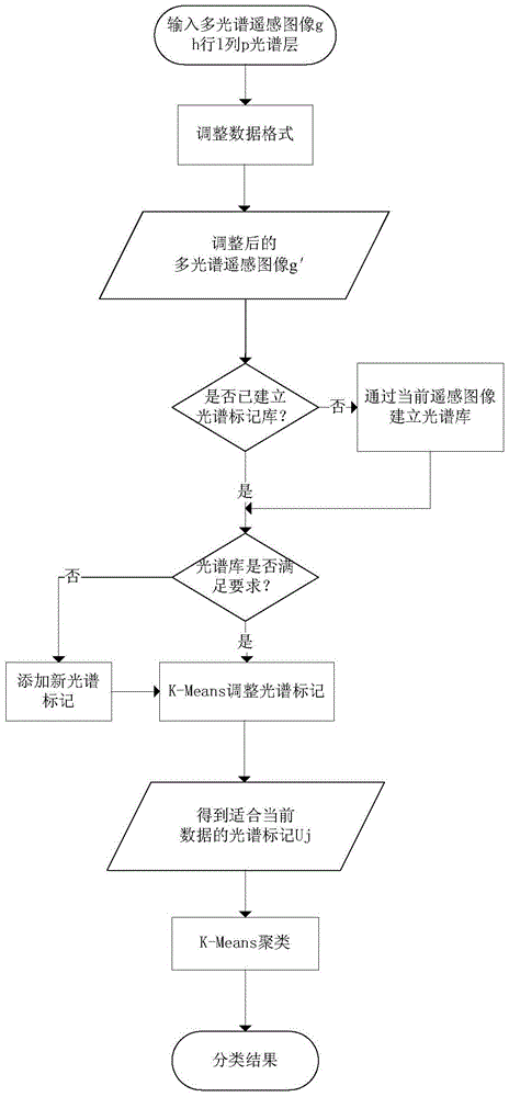
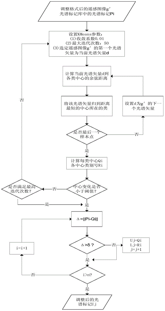
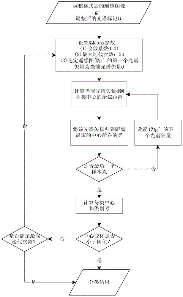
[0029] The steps for implementing the present invention will be further described in detail below in conjunction with the accompanying drawings.

[0030] refer to figure 1 , the implementation steps of the present invention are as follows:

[0031] Step 1, input the multispectral remote sensing image g, the number of rows of the multispectral remote sensing image is h, the number of columns is l, and the number of spectral layers is p, where h>0, l>0, p≥4 , And adjust the data format of these remote sensing images to construct the spectral vector SV:

[0032] (1a) Save the number of rows of the multispectral remote sensing image g as h, the number of columns as l, and the number of spectral layers as p;

[0033] (1b) Make cumulative histogram adjustments on the images of each spectral layer of the multispectral remote sensing image g, and obtain the adjusted multispectral remote sensing image g′:

[0034] (1b1) Save the sub-image of the kth spectral layer in the multispectr...


PUM


Abstract

The invention discloses a spectral tag based adaptive multi-spectral remote sensing image classification method, and mainly solves the problem that automatic classification is difficult to realize due to the fact that manual operation is required during remote sensing image classification in the prior art. The method includes the realization steps: (1) inputting multi-spectral remote sensing images; (2) adjusting data formats of the multi-spectral remote sensing images; (3) completing a spectral tag library through the adjusted multi-spectral remote sensing images; (4) adjusting spectral tags through a K-Means clustering algorithm; (5) adopting the adjusted spectral tags as weak supervisory information to perform weak supervision classification to obtain classification results. By the method, manual operation during classification is avoided, classification precision is improved, classification speed is increased, and the method can be used for land coverage information analysis.

Description

technical field [0001] The invention belongs to the field of image processing, and further relates to a method for classifying multispectral remote sensing images, which can be used for analyzing land cover conditions. Background technique [0002] Multi-spectral remote sensing images are high-resolution images obtained by scanning the ground with satellite multi-spectral scanning systems, and their rich information provides the possibility for computer recognition and classification of ground object images. However, due to its low spectral dimension, the extraction of land use and coverage information has become one of the difficulties in remote sensing information processing. With the rapid development of the national economy, the degree and speed of changes in land use are accelerating, and there is an urgent need for fast and accurate land use information acquisition methods, that is, to classify remote sensing images according to land use. [0003] There are many exist...

Claims


Application Information

Patent Timeline
Patent Type & Authority Patents(China)
IPC IPC(8): G06K9/62
Inventor 高新波王颖张琪王秀美高宪军吴晟杰李圣喜于昕晔王斌牛振兴
Owner XIDIAN UNIV
Why Eureka
Try Eureka