Standard-resolution physical three-dimensional terrain surface model machining system and method thereof

A 3D terrain and surface model technology, applied in general control systems, control/regulation systems, simulators, etc., can solve problems such as high cost, inability to apply physical or semi-physical simulation systems, and unknown real 3D coordinate data of 3D terrain models , to achieve a good practical effect

Inactive Publication Date: 2015-04-22
CIVIL AVIATION UNIV OF CHINA
View PDF7 Cites 4 Cited by
  • Summary
  • Abstract
  • Description
  • Claims
  • Application Information

AI Technical Summary

Problems solved by technology

However, the cost of surveying and remote sensing measurement of actual terrain is high, and it is difficult for most research institutions and individuals to complete scientific research work that requires the participation of actual terrain, nor can it meet the needs of scientific experiments for some customized experiments, such as: Using the solid three-dimensional terrain surface model with known resolution (or accuracy), through the establishment of remote sensing stereo imaging (or measurement) half-in-the-loop simulation test system, quantitatively study the imaging system parameters, orbit parameters and attitude parameters and other factors for remote sensing stereo imaging (or measurement) The mathematical model of the influence of measurement) accuracy
[0003] However, the 3D digital terrain model is only a 3D visualization of the actual terrain, stored in the computer in the form of digital data, and cannot be applied to physical or semi-physical simulation systems that require the participation of the actual terrain model
At the same time, due to the inherent processing error of the processing system, the real 3D coordinate data of the processed solid 3D terrain model is unknown

Method used


Image

  • Standard-resolution physical three-dimensional terrain surface model machining system and method thereof
  • Standard-resolution physical three-dimensional terrain surface model machining system and method thereof

Examples


Embodiment Construction

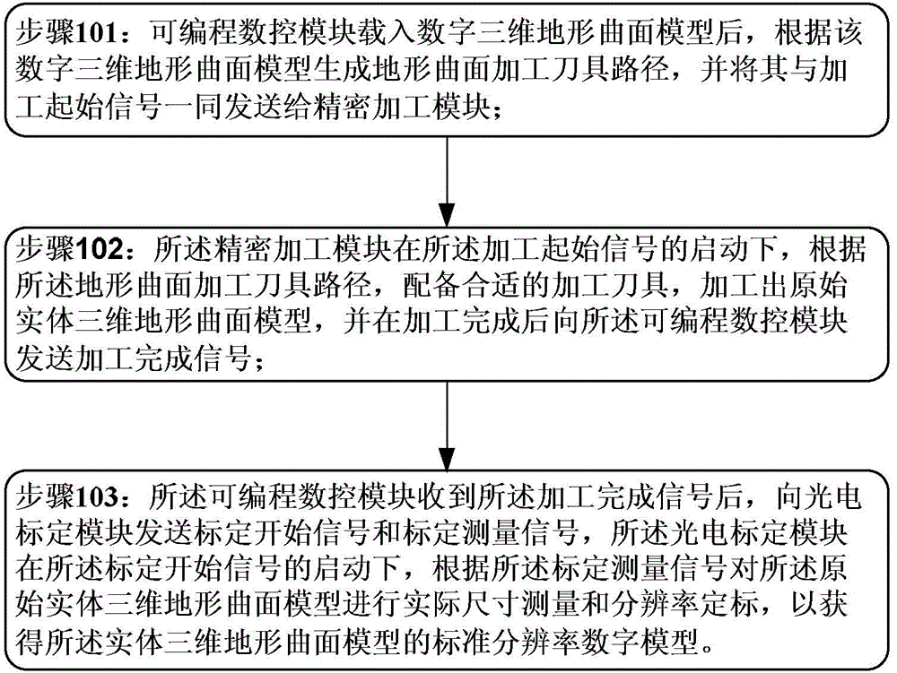
[0020] The technical solutions in the embodiments of the present invention will be clearly and completely described below in conjunction with the accompanying drawings in the embodiments of the present invention. Obviously, the described embodiments are only part of the embodiments of the present invention, not all of them. Based on this The embodiments in the invention, and all other embodiments obtained by persons of ordinary skill in the art without creative effort, all belong to the scope of protection of the present invention.

[0021] In the present invention, the standard resolution solid three-dimensional topographic surface model includes the original solid three-dimensional topographic surface model and a standard resolution digital model, wherein: the original solid three-dimensional topographic surface model is a miniature physical model corresponding to the real topography, which is On the basis of the digital elevation model of the actual terrain and landform, the...


PUM


Abstract

Provided are a standard-resolution physical three-dimensional terrain surface model machining system and a method thereof. The system comprises a programmable numerical control module, a precision machining module, and a photoelectric calibration module, wherein the programmable numerical control module is connected with the precision machining module and the photoelectric calibration module. The invention provides the standard-resolution physical three-dimensional terrain surface model machining system and the standard-resolution physical three-dimensional terrain surface model machining method. A standard-resolution physical three-dimensional terrain surface model machining system with an optical-electro-mechanical integrated structure is constructed. Materialization and resolution calibration of a digital three-dimensional terrain surface are realized, so that a standard-resolution physical three-dimensional terrain surface model which can be applied to a physical or semi-physical simulation system can be obtained. The system and the method of the invention have high practicability. A digital three-dimensional terrain model can be effectively made into a standard-resolution physical three-dimensional terrain surface mode. A physical basis is provided for scientific research.

Description

technical field [0001] The invention belongs to the technical field of three-dimensional terrain modeling, and in particular relates to a standard-resolution solid three-dimensional terrain surface model processing system and a method thereof. Background technique [0002] 3D digital terrain modeling is based on terrain data obtained through different measurement methods, and realizes 3D visualization of actual terrain through computer programming. It has been widely used in geological analysis, road design, remote sensing measurement and other fields. At present, in the scientific research involving 3D digital terrain modeling, it mainly focuses on how to optimize the data structure, adopt different interpolation methods, adopt overall modeling or block modeling, etc., to obtain higher precision, and even resolution can be obtained. A variable 3D digital terrain model. However, the cost of surveying and remote sensing measurement of actual terrain is high, and it is diffic...

Claims


Application Information

Patent Timeline
Patent Type & Authority Applications(China)
IPC IPC(8): G05B19/4099
CPCG05B19/4099
Inventor 贾桂敏王向军马金驹张召才
Owner CIVIL AVIATION UNIV OF CHINA
Why Eureka
Try Eureka