Single-person positioning navigator and positioning navigation method based on multi-sensor fusion

A multi-sensor fusion, positioning and navigation technology, applied in the field of inertial systems, can solve the problems of inability to achieve indoor positioning and fully autonomous navigation, and achieve the effects of light weight, small size and low cost

CN105628024BActive Publication Date: 2018-09-04CHINA ELECTRONICS TECH GRP NO 26 RES INST
6 Cites 0 Cited by

Patent Information

Authority / Receiving Office
CN · China
Patent Type
Patents(China)
Current Assignee / Owner
Publication Date
2018-09-04

Smart Images

  • Figure 1
    Figure 1
Patent Text Reader

Abstract

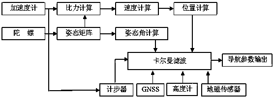
The invention discloses a single person positioning navigator based on multi-sensor fusion and a positioning and navigating method. The single person positioning navigator comprises a global satellite positioning system, a barometer, a three-axis gyroscope, a three-axis accelerometer and three-axis geomagnetic sensors. Attitude angle information obtained through the gyroscope, position information obtained through the accelerometer, human body course information provided by the geomagnetic sensors, height information provided by the barometer, stride frequency information worked out by the accelerometer, and position and speed information provided by the global satellite positioning system are input into a kalman filter together, multi-information fusion is carried out through a kalman filter algorithm, and thus positioning and navigating parameters are output. Even when the global satellite positioning system cannot stably receive information due to shielding, electromagnetic interference and other factors, the single person positioning navigator based on multi-sensor fusion and the positioning and navigating method can achieve effective positioning and navigating and are suitable for various environments such as inside rooms or inside tunnels. By means of the single person positioning navigator based on multi-sensor fusion and the positioning and navigating method, positioning errors accumulated along with time can be reduced, and accurate individual 3D positioning can be achieved.
Need to check novelty before this filing date? Find Prior Art

Description

technical field

[0001] The invention relates to inertial navigation and integrated navigation, in particular to a multi-sensor fusion-based single-person positioning navigator and a positioning and navigation method, belonging to the technical field of inertial systems. Background technique

[0002] At present, micro-mechanical (MEMS) technology is quite mature, and it is widely used in various fields of military and civilian, and it is also true in the field of inertia. Due to their small size, low power consumption, light weight and low cost, MEMS gyroscopes and MEMS accelerometers are widely used in the fields of model aircraft, drones, cameras and mobile phones. In addition, sensors such as satellite navigation systems, geomagnetic sensors and barometers are also widely used in car navigation, flight control and other occasions.

[0003] Personal navigation system, PNS (Personal / Pedestrian Navigation System) is mainly used to track and locate the real-time position of w...

Examples

Embodiment Construction

[0017] The present invention will be described in detail below in conjunction with the accompanying drawings and specific embodiments.

[0018] see figure 1 , as can be seen from the figure, the present invention is based on a single-person positioning navigator based on multi-sensor fusion, including a global satellite positioning system, a barometer for measuring altitude, a three-axis gyroscope, a three-axis accelerometer and a three-axis geomagnetic sensor, A three-axis gyroscope and a three-axis accelerometer form a micromechanical inertial navigation unit. The attitude angle information obtained by the gyroscope, the position information obtained by the accelerometer, the heading information of the human body provided by the geomagnetic sensor, the altitude information provided by the barometer, and the accelerometer calculate The step frequency information and the position and speed information provided by the global satellite positioning system are input into the Kalma...