GPS data-based traffic congestion propagation path calculating method

A technology of GPS data and transmission path, applied in the field of intelligent transportation system, can solve problems such as road network congestion and downstream road congestion

Inactive Publication Date: 2016-08-24
HANGZHOU YUANTIAO TECH CO LTD
View PDF6 Cites 15 Cited by
  • Summary
  • Abstract
  • Description
  • Claims
  • Application Information

AI Technical Summary

Problems solved by technology

If this impact accumulates to a certain extent, it will cause congestion on downstream roads
Then, this congestion will continue to spread in the road network, causing congestion of the entire road network

Method used


Image

  • GPS data-based traffic congestion propagation path calculating method
  • GPS data-based traffic congestion propagation path calculating method

Examples


Embodiment Construction

[0024] In order to make the object, technical solution and advantages of the present invention clearer, the present invention will be described in detail below with reference to the accompanying drawings and examples.

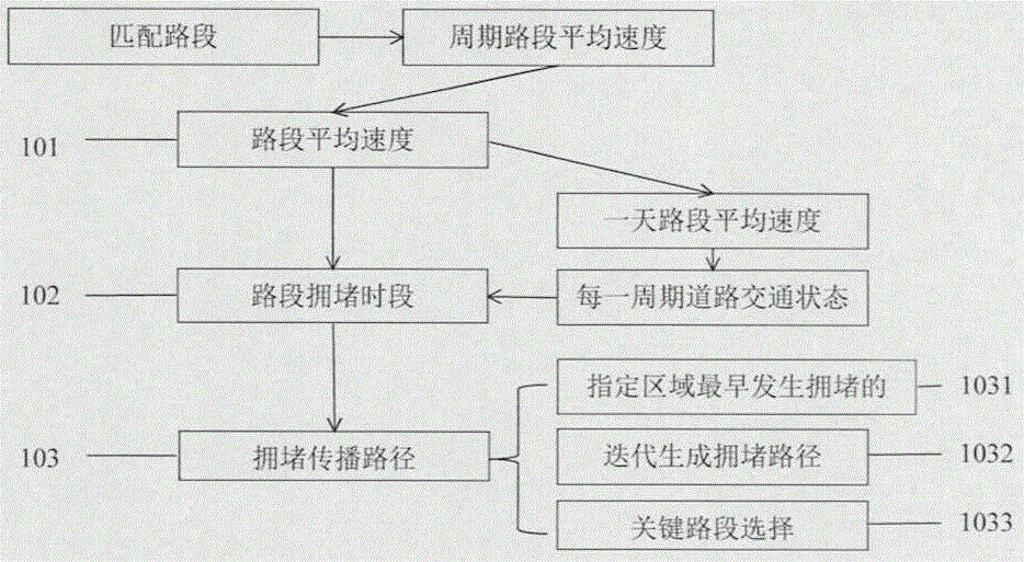
[0025] refer to figure 1 , the calculation process of the present invention includes:

[0026] Step 101: Calculate the average speed of the road section

[0027] Using the data collected by the GPS floating car, calculate the average speed of the road with the road segment ID 0000000001401 in the Hangzhou road network within a time period. The GPS data collected in this time period is a collection of a series of points, denoted as . First, according to the latitude and longitude information of the road section provided by the digital map, and the latitude and longitude information of the collected points, use the orthogonal projection method to match the points to the corresponding road section; then, calculate the average speed of all points projected to the...


PUM


Abstract

The invention relates to a GPS data-based traffic congestion propagation path calculating method. By processing and analyzing a large quantity of data collected by a GPS floating vehicle, an urban road network traffic congestion propagation path can be calculated. First, according to the large quantity of GPS data collected by the floating vehicle, average speed of each road segment in a road network is calculated; according to the average speed of each road segment, a congestion time period of each road segment is calculated; according to the congestion time period of each road segment in the road network, a congestion propagation path and key road segments are calculated. According to the GPS data-based traffic congestion propagation path calculating method, based on a sequence of the congestion time period of each road segment in a regional road network, road congestion propagation condition in the road network can be estimated. The calculated key road segments in the propagation path can be applied to police strength deployment, congestion prediction and road planning.

Description

technical field [0001] The invention relates to a GPS data-based traffic congestion propagation path calculation method, which belongs to the category of intelligent traffic systems. Background technique [0002] Traffic congestion has seriously affected people's daily life and has become a hot spot for the whole society. Administrative measures can alleviate traffic congestion to a certain extent. Among them, the guidance of traffic police on specific road sections is an important way. However, due to many congested road sections and limited police force, it is difficult to deploy police force to every congested road section. Therefore, it is necessary to find the most reasonable way to deploy police force. The traffic congestion propagation path reflects the situation that the congestion spreads between adjacent road segments. The key road sections that cause regional congestion can be automatically found through the calculation method of congestion propagation path. ...

Claims


Application Information

Patent Timeline
Patent Type & Authority Applications(China)
IPC IPC(8): G08G1/00
Inventor 夏莹杰单振宇谷虹娴
Owner HANGZHOU YUANTIAO TECH CO LTD
Why Eureka
Try Eureka