Satellite remote sensing image processing method based on visual fidelity

A satellite remote sensing and image processing technology, applied in the field of aerospace remote sensing image processing, can solve problems such as difficulty in obtaining the real situation of ground objects, weakening of interpretation and interpretation capabilities, etc., to improve interpretation and interpretation capabilities, achieve visual fidelity, improve The effect of processing speed

Active Publication Date: 2016-10-12
CHINA CENT FOR RESOURCES SATELLITE DATA & APPL
View PDF4 Cites 5 Cited by
  • Summary
  • Abstract
  • Description
  • Claims
  • Application Information

AI Technical Summary

Problems solved by technology

same picture Like using different software to display, the effect may be completely different, it is difficult to obtain the real situation of ground objects, picture Impaired ability to read and interpret

Method used


Image

  • Satellite remote sensing image processing method based on visual fidelity
  • Satellite remote sensing image processing method based on visual fidelity
  • Satellite remote sensing image processing method based on visual fidelity

Examples


Embodiment

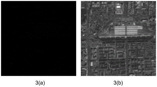
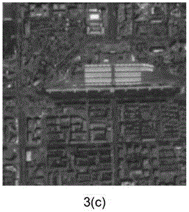
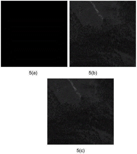
[0068] Adopt the method of the present invention to remote sensing of mainstream satellites at home and abroad picture Imagery (including Ziyuan-3, Gaofen-2 and IKONOS satellite remote sensing picture Image) for preprocessing, the targets of Ziyuan-3, Gaofen-2 and IKONOS satellite imaging are railway stations, stadiums and mountains respectively. The effective quantization bits of Ziyuan No. 3 and Gaofen No. 2 are 10, and the effective quantization bits of IKONOS satellite are 11.

[0069] From image 3 (a), Figure 4 (a) and Figure 5 From (a), it can be seen that due to the satellite picture For example, 10 or 11-bit quantization is used, and the high-order bit of the high byte is zero. Resource No. 3, Gaofen No. 2 and IKONOS satellite remote sensing picture The brightness of the image is very low, and it is displayed as a black screen in the computer, and ground objects and targets cannot be found.

[0070] image 3 (b), Figure 4 (b) is the processed remote sensing...


PUM


Abstract

Provided is a satellite remote sensing image processing method based on visual fidelity. The method comprises steps of: reading the DN data of each pixel of a high-radiation-resolution satellite remote sensing image (over 8 quantified bits), acquiring the valid quantified bits n of the satellite remote sensing image, right shifting each of the bits from 0 to 2n-1 of the data by (n-8) bits, and forcibly keeping low byte information, or left shifting each of the bits from 0 to 2n-1 of the data by (16-n) bits to obtain a comparison table including original data and stretched data for achieving color level reconstruction; according to the comparison table, performing tone mapping to obtain the stretched data DN data of each pixel of the satellite remote sensing image, thereby obtain the satellite remote sensing image with visual fidelity. The method guarantees that the brightness of the image complies with an imaging case, considers a requirement for visual fidelity, may acquire ground actual case, and increases image interpretation capability.

Description

technical field [0001] The invention relates to a satellite remote sensing system mainly aimed at high radiation resolution picture A preprocessing method based on visual fidelity such as (quantization bits exceeding 8 bits), which belongs to aerospace remote sensing picture Like dealing with technical fields. Background technique [0002] Radiation resolution, also known as radiation sensitivity, refers to the minimum radiation difference that a satellite camera can distinguish when receiving target reflection or radiation signals. The changes of ground features in space, spectrum and time are reflected by the distribution and changes of its radiation, so the radiation resolution is an important index for satellites to obtain ground information. In order to ensure that the specified radiation resolution is achieved, when the analog signal output by the satellite is converted into a digital signal (A / D conversion), the quantization layer must be reasonably selected, that i...

Claims


Application Information

Patent Timeline
Patent Type & Authority Applications(China)
IPC IPC(8): G06T5/00
CPCG06T5/003G06T2207/10032
Inventor 曾湧陈卫荣龙小祥易维黄树松
Owner CHINA CENT FOR RESOURCES SATELLITE DATA & APPL
Why Eureka
Try Eureka