Satellite visibility analysis and ephemeris prediction methods considering satellite occlusion conditions

An analysis method and satellite technology, applied to satellite radio beacon positioning systems, measuring devices, instruments, etc., can solve problems such as inaccurate ephemeris forecasts and deviations in analysis results

Active Publication Date: 2017-07-21
POWERCHINA XIBEI ENG
View PDF6 Cites 14 Cited by
  • Summary
  • Abstract
  • Description
  • Claims
  • Application Information

AI Technical Summary

Problems solved by technology

[0005] An object of the present invention is to provide a satellite visibility analysis method that takes into account GNSS satellite occlusion conditions, which solves the problem that the existing GNSS satellite visibility analysis does not take into account that there is no measurement when there is an obstacle occlusion at the observation site in the canyon area or urban building environment. The problem that the station occlusion condition leads to a large deviation in the analysis results
[0006] Another object of the present invention is to provide a method of ephemeris prediction that takes into account the satellite occlusion condition, which solves the problem that the existing DOP value calculation does not take into account the station occlusion condition and causes the inaccurate ephemeris forecast when there is an obstacle occlusion at the station.

Method used


Image

  • Satellite visibility analysis and ephemeris prediction methods considering satellite occlusion conditions
  • Satellite visibility analysis and ephemeris prediction methods considering satellite occlusion conditions
  • Satellite visibility analysis and ephemeris prediction methods considering satellite occlusion conditions

Examples


Embodiment Construction

[0042] The present invention will be further described in detail below in conjunction with the accompanying drawings and specific embodiments, but the present invention is not limited to these embodiments.

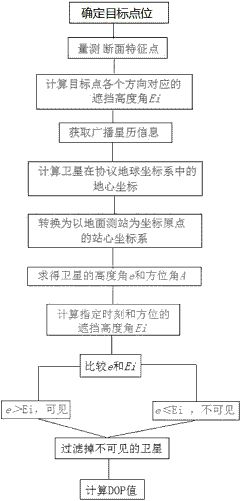
[0043] The satellite visibility analysis method considering the satellite occlusion condition of the present invention, refer to figure 1 , including the following steps:

[0044] Step 1, measuring the satellite occlusion altitude angle of the target point;

[0045] Based on topographic maps, digital elevation models (DEM) or other digital geographic information products with elevation attributes, the elevation angle of a single station satellite is measured.

[0046] First determine the coordinates of the target point, and then measure a section at a certain angle (for example, 5°) clockwise from the north direction with the target point as the center (the distance of the cross section is determined according to the actual situation), according to the measured feature po...


PUM


Abstract

The invention discloses a satellite visibility analysis method considering satellite occlusion conditions, comprising the following steps: S1, measuring the occlusion elevation angle Ei of a satellite at a target point; S2, calculating the spatial position of the satellite and carrying out coordinate transformation; and S3, in a station center coordinate system with a ground survey station R as the origin, calculating out the instantaneous elevation angle e and azimuth angle A of the satellite; calculating the occlusion elevation angle Ei at corresponding time and at corresponding azimuth A; comparing the elevation angle e of the satellite with the occlusion elevation angle Ei at the corresponding time and at the corresponding azimuth; if e<=Ei, judging that the satellite is not visible, and removing the satellite; if e>Ei, judging that the satellite is visible, and keeping the satellite; and filtering satellites according to the method, and obtaining an accurate satellite visibility result. The precision factor of a single survey station is evaluated according to the satellite visibility analysis result, and thus, ephemeris prediction is realized. The method of the invention is suitable for carrying out ephemeris prediction of GNSS observation in alpine and gorge regions and in regions difficult to observe under the effect of city buildings. The problem that the traditional ephemeris prediction result is inconsistent with the actual observation conditions is solved.

Description

technical field [0001] The invention belongs to the technical field of GNSS control network measurement, and in particular relates to a satellite visibility analysis method taking into account the satellite occlusion condition, and also relates to an ephemeris forecasting method taking the satellite occlusion condition into consideration. Background technique [0002] The accuracy of GNSS control network measurement affects the accuracy of the collected data, which is affected by factors such as the number of satellites that can be received per unit time, the distribution of satellites, and the duration of received satellite signals. Therefore, when planning a survey plan, it is usually necessary to forecast the ephemeris of the survey area. Through the forecast ephemeris, the distribution of satellites and the forecast precision factor (DOP value) in a certain period of time in the future can be known in advance, and the whole network of the engineering network can be estima...

Claims


Application Information

Patent Timeline
Patent Type & Authority Applications(China)
IPC IPC(8): G01S19/20G01S19/27
CPCG01S19/20G01S19/27
Inventor 李祖锋
Owner POWERCHINA XIBEI ENG
Why Eureka
Try Eureka