A mobile terminal-based remote sensing image data processing system and data processing method

A data processing system, remote sensing image technology, applied in the direction of image data processing, image data processing, special data processing applications, etc., can solve the problem of inefficient use of mobile terminal computing resources, increase of server-side workload, and network conditions. Advanced problems, to achieve fast processing and display, perfect user experience, and low hardware configuration requirements

Active Publication Date: 2020-08-25
SECOND INST OF OCEANOGRAPHY MNR
View PDF7 Cites 0 Cited by
  • Summary
  • Abstract
  • Description
  • Claims
  • Application Information

AI Technical Summary

Problems solved by technology

[0004] However, in the existing WebGIS solutions and application cases, a large amount of data analysis work is done on the server side, and the main task of the mobile terminal is to obtain and display the massive remote sensing image data released by the server side through the network in the user interface. , which has higher requirements on the network conditions of the user's environment
The transmission of massive high-resolution remote sensing data will be affected by network bandwidth, delay, etc., which reduces user experience; Efficient use of computing resources on the mobile side

Method used


Image

  • A mobile terminal-based remote sensing image data processing system and data processing method
  • A mobile terminal-based remote sensing image data processing system and data processing method
  • A mobile terminal-based remote sensing image data processing system and data processing method

Examples


Embodiment Construction

[0029] The present invention is not limited to the above embodiments, and various changes can be made within the scope of the invention described in the claims, and it goes without saying that these changes are also included in the scope of the present invention.

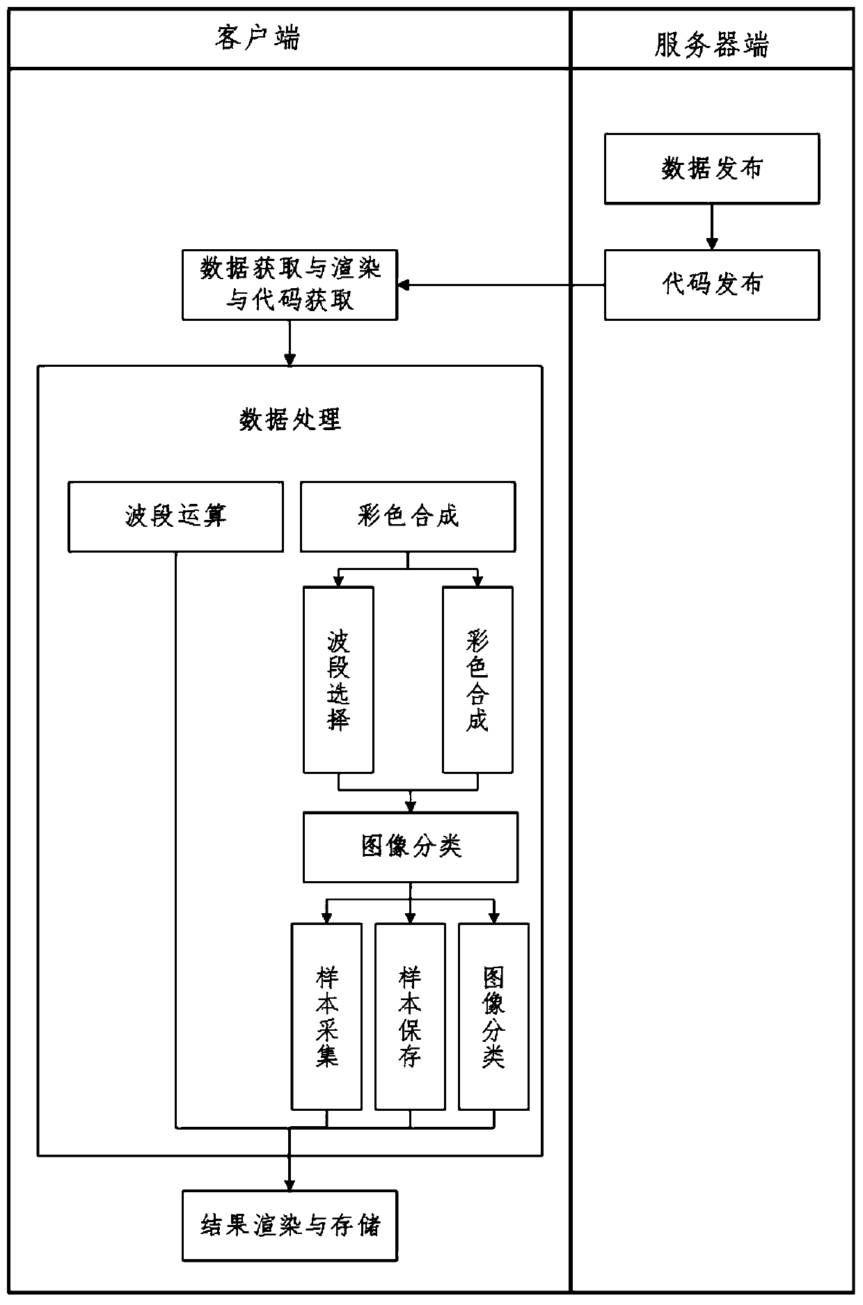
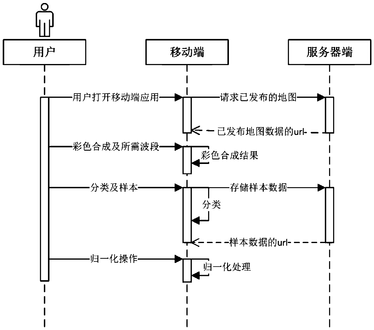
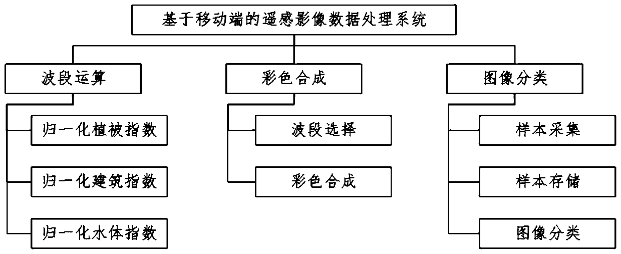
[0030] Such as image 3 and 4 As shown, a remote sensing image data processing system based on a mobile terminal, the mobile terminal includes a band calculation module, a color synthesis module and an image classification module;

[0031] The band operation module is used to perform mathematical operations on the single-band remote sensing image data released by the server, specifically including normalized vegetation index, normalized building index and normalized water body index;

[0032] The color synthesis module performs color synthesis of remote sensing images according to user requirements, specifically including a band selection module and a color synthesis module;

[0033] The image classification modul...


PUM


Abstract

The invention discloses a remote sensing image data processing system and data processing method based on a mobile terminal. The mobile terminal includes a band calculation module, a color synthesis module and an image classification module. Band image and vector data, the mobile terminal receives and performs band calculation, image classification and color synthesis on it. The data processing system and method of the present invention eliminates the frequent interaction between the client and the server, saves computing resources of the server; and in an environment with poor network conditions (such as in the wild), real-time display and processing of image data can be realized, The user experience has been improved, and the system has low requirements on hardware configuration and good portability. Moreover, due to the use of open source technology, the technical cost is low, so it can be widely used in geological surveys, field rescue and other high-immediacy tasks.

Description

technical field [0001] The invention relates to the field of remote sensing image processing, in particular to a remote sensing image data processing system and data processing method based on a mobile terminal. Background technique [0002] With a series of satellites launched by NASA's Global Observing System and other international and commercial projects, remote sensing imagery data has gradually become an important data source in earth science research. In order to better apply remote sensing image data, many scholars regard Web Geographic Information System (WebGIS) as an effective tool to realize the display, spatial analysis, data mining and data sharing of remote sensing image data. WebGIS is a new technology that uses Internet technology to expand and improve traditional GIS, and is an ideal solution to realize GIS interoperability. WebGIS makes up for the shortcomings of traditional GIS in data sharing. Its core is to embed the application system of HTTP standard...

Claims


Application Information

Patent Timeline
Patent Type & Authority Patents(China)
IPC IPC(8): G06T5/50G06F16/29G06F16/56G06K9/62G06T1/00
CPCG06F16/29G06F16/56G06T1/00G06T5/50G06T2207/10024G06F18/241
Inventor 陈建裕赵艳慧张贝娜陈宁华
Owner SECOND INST OF OCEANOGRAPHY MNR
Why Eureka
Try Eureka