Evaluation method and system for mutual assistance navigation positioning data confidence level

A navigation positioning and navigation data technology, applied in the direction of electrical digital data processing, special data processing applications, instruments, etc., can solve problems such as damage to the aided party, application failure of the aided party, misleading the aided party, etc.

Active Publication Date: 2018-06-01
ACAD OF OPTO ELECTRONICS CHINESE ACAD OF SCI
View PDF2 Cites 5 Cited by
  • Summary
  • Abstract
  • Description
  • Claims
  • Application Information

AI Technical Summary

Problems solved by technology

If the navigation and positioning data provided by the donor is not credible, or if the navigation and positioning data is tampered with during transmission, it will mislead the recipient, cause the recipient to fail subsequent applications, and even cause physical damage to the recipient

Method used


Image

  • Evaluation method and system for mutual assistance navigation positioning data confidence level
  • Evaluation method and system for mutual assistance navigation positioning data confidence level
  • Evaluation method and system for mutual assistance navigation positioning data confidence level

Examples


Embodiment Construction

[0036] The specific implementation manners of the present invention will be further described in detail below in conjunction with the accompanying drawings and embodiments. The following examples are used to illustrate the present invention, but are not intended to limit the scope of the present invention.

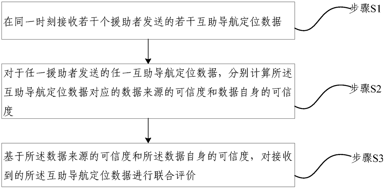
[0037] figure 1 It is a flow chart of a method for evaluating the credibility of mutual aided navigation and positioning data provided by an embodiment of the present invention, as shown in figure 1 As shown, the method includes:

[0038] Step S1, receiving several mutual assistance navigation positioning data sent by several assistance terminals at the same time;

[0039] Step S2. For any mutual assistance navigation and positioning data sent by any assistance terminal, respectively calculate the credibility of the data source corresponding to the mutual assistance navigation and positioning data and the credibility of the data itself;

[0040] Step S3, based on the cr...


PUM


Abstract

The invention provides an evaluation method for a mutual assistance navigation positioning data confidence level. The method comprises the following steps that: at the same moment, receiving multiplepieces of mutual assistance navigation positioning data sent from a plurality of assistance terminals; for any one piece of mutual assistance navigation positioning data sent from any one piece of navigation positioning data, independently calculating the confidence level of a data source corresponding to the mutual assistance navigation positioning data and the own confidence level of the data; and on the basis of the confidence level of the data source and the own confidence level of the data, carrying out joint evaluation on the received mutual assistance navigation positioning data. By useof the evaluation method for the mutual assistance navigation positioning data confidence level, assistance terminal data credibility, intermediate transmission node credibility, a data supporting relationship and a data conflict relationship are used for evaluation, no priori knowledge is depended, the confidence levels of preorder data and subsequent data are not depended, and the method can adapt to the continuous change of a mutual assistance navigation application scene.

Description

technical field [0001] The field of navigation and positioning data processing of the present invention, more specifically, relates to a method and system for evaluating the credibility of mutual assistance navigation and positioning data. Background technique [0002] There is a huge demand for spatio-temporal information. At present, with the rapid development of satellite navigation, wireless communication and other technologies, the promotion and popularization of various positioning terminals and communication terminals, and the continuous improvement of network infrastructure, mutual aid navigation and positioning has been applied. Mutual assistance in navigation and positioning refers to a party with navigation and positioning information, such as individuals, terminal devices, network servers, etc. sharing or sending navigation and positioning information to others or systems. Other people or systems are called recipients, enabling recipients to carry out subsequent...

Claims


Application Information

Patent Timeline
Patent Type & Authority Applications(China)
IPC IPC(8): G06F17/30G06K9/62
CPCG06F16/9535G06F16/9537G06F18/24155
Inventor 曲艺吴海涛
Owner ACAD OF OPTO ELECTRONICS CHINESE ACAD OF SCI
Why Eureka
Try Eureka